- Geography India - Introduction
- Geography India - Physical Aspect
- Geography India - Drainage System
- Geography India - Climate
- Geography India - Natural Vegetation
- Geography India - National Forest
- Geography India - Wildlife
- Geography India - Soil
- Geography India - Land Resources
- Geography India - Agriculture
- Geography India - Mineral Resources
- Geography India - Energy Resources
- Geography India - Industry
- Geography India - Transport
- Geography India - Communication
- Geography India - Foreign Trade
- Geography India - The People
- Geography India - Settlement
- Geography India - Migration
- Regional Development
- Geography India - Disasters
- Geography of the World
- Geography World - Introduction
- Evolution of the Earth
- Geography World - Climate
- Geography World - Transport
- Geography World - Communications
- Geography World - Population
- Human Settlement
- Human Development
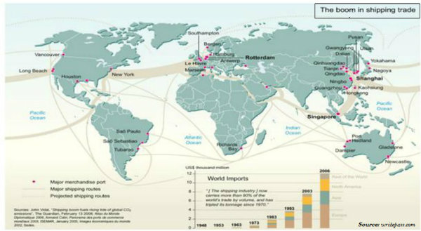
- International Trade
- Geography Useful Resources
- Geography - Online Quiz
- Geography - Online Test
- Geography - Quick Guide
- Geography - Useful Resources
- Geography - Discussion
Geography - Quick Guide
Geography India - Introduction
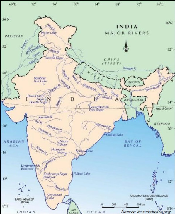
India - Location
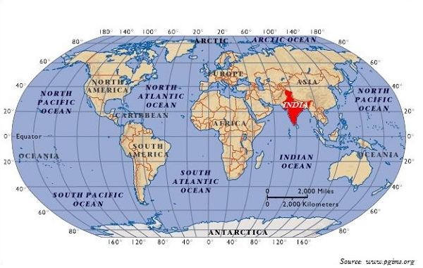
India is located entirely in the northern hemisphere; specifically in the south-central part of the continent of Asia.
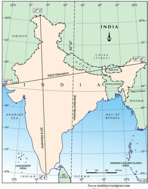
The mainland of India extends between latitudes 8°'N and 37°6'N and longitudes 68°7'E and 97°25'E (as shown in the map given below). The southern boundary extends up to 6°45'N latitude in the Bay of Bengal.
India - Size
With an area of 3.28 million square km, India is the 7th largest country of the world.
The six largest countries of the world in decreasing order are Russia, Canada, USA, China, Brazil, and Australia.
India accounts for about 2.4 percent of the total geographical area of the world.
India has a total land boundary of about 15,200 km.
The coastline of India stretches along the Bay of Bengal in the east and the Arabian Sea in the west (as shown in the map given above).
From Gujarat (westernmost) to Arunachal Pradesh (easternmost), there is about 30°difference; hence, because of this difference, there is a time difference of two hours between Gujarat and Arunachal Pradesh.
The sun rises in Arunachal Pradesh about two hours earlier as compared to Jaisalmer in Rajasthan.
The maximum length of the mainland from north to south is about 3214 km.
The maximum length of the mainland from east to west is about 2933 km.
Indias total length of coastline is 6,100 km of its mainland and after including Andaman and Nicobar, and Lakshadweep islands, it is about 7,516 km.
Indias territorial limit further extends towards the sea up to 12 nautical miles (i.e. about 21.9 km) from the coast.
Indian Standard Meridian
82°30'E Meridian crossing through the Mirzapur city of Uttar Pradesh is taken as Indias Standard Meridian.
Indian Standard Time is ahead of Greenwich (0° or Prime Meridian) Mean Time by 5 hours and 30 minutes.
Tropic of cancer (23°30'N) passes through Gujarat, Madhya Pradesh, Chhattisgarh, Jharkhand, West Bengal, Tripura, and Mizoram.
The difference in latitudinal extent influences the duration of day and night.
India and Neighbors
India has total 29 States, 6 Union Territories, and 1 National Capital Territory.
India is bounded by young fold mountains (the Great Himalaya) in the North and North-East.
Throughout the history, Indias connections with other parts of the world has been heavily influenced by waterways and also the mountain passes.
India shares its international boundaries with Afghanistan and Pakistan in the North-West; China, Tibet (China), Nepal, and Bhutan in the North and NorthEast; and Myanmar and Bangladesh in the East.
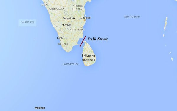
Island countries Sri Lanka and Maldives are Indias neighbors across the sea.
Sri Lanka is an island nation located off the southern coast of India in South Asia and it is bordered by the Indian Ocean. India and Sri Lanka are separated by a thin water body called the Palk Strait.
Maldives is a chain of islands located south-west of Sri Lanka and India in the Indian Ocean.
Geography India - Physical Aspect
India - Evolution
As per the estimation, the earth is approximately 460 million years old.
The endogenic and exogenic forces played a significant role in giving shape to various surface and subsurface features of the earth.
The theory of Plate Tectonics defines the formation of physical aspects of the earth.
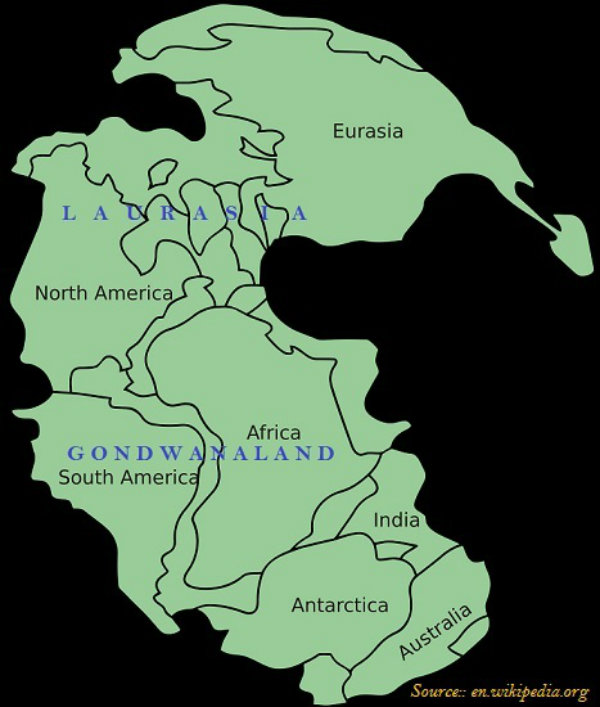
Initially, all continents were united (there was one landmass), and known as Pangea or Super Continent (as shown in the image given below).
The northern part of the ancient super continent Pangea was named as Angara Land or Laurasia and the southern part was named as Gondwana Land.
The Gondwana Land includes India, Australia, South Africa, South America, and Antarctica.
India - Structure
Based on geological history, India is divided into three regions. The regions are −
The Peninsular Block;
The Himalayas & other Peninsular Mountains; and
Indo-Ganga-Brahmaputra Plain.
The Peninsular Block is formed essentially by a great complex of very ancient gneisses and granites.
The Peninsular Block mostly consists of relicts and residual mountains like the Aravali hills, the Nallamala hills, the Javadi hills, the Veliconda hills, the Palkonda range, the Mahendragiri hills, etc.
Unlike the rigid and stable Peninsular Block, the Himalayan Mountains are young, weak, and flexible in their geological structure.
Indo-Ganga-Brahmaputra Plain comprises the plains formed by the river Indus, the Ganga, and the Brahmaputra.
In fact, Indo-Ganga-Brahmaputra Plain is a geo-synclinal depression, which attained its maximum development during the third phase of the Himalayan mountain formation, approximately about 64 million years ago.
Physiography
Indias physiography is divided into six following regions −
The Northern and Northeastern Mountains
The Northern Plain
The Peninsular Plateau
The Indian Desert
The Coastal Plains
The Islands
Northern and Northeastern Mountains
The Northern and the Northeastern Mountains consist of the Himalayas and the Northeastern hills.
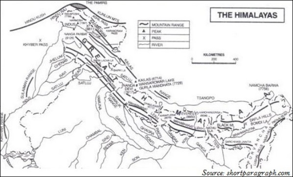
The Himalayan Ranges include the Greater Himalaya, Lesser/Middle Himalaya, and the Siwalik Range.
Based on relief, alignment of ranges and other geomorphological features, the Himalayas can be divided into the following sub-divisions −
Kashmir or Northwestern Himalayas
Himachal and Uttaranchal Himalayas
Darjeeling and Sikkim Himalayas
Arunachal Himalayas
Eastern Hills and Mountains.
Kashmir or Northwestern Himalayas
Kashmir or Northwestern Himalayas consist of a series of ranges such as the Karakoram, Ladakh, Zanskar, and Pir Panjal.
Important glaciers of South Asia, i.e., the Baltoro and Siachen are found in the Northwestern Himalayan region.
The Kashmir Himalayas are also popular for the Karewa formations, which are useful for the cultivation of Zafran, a local variety of saffron.
Karewas are the thick deposits of glacial clay and other materials embedded with moraines.
Important passes of the Northwestern Himalayas are Zoji La on the Great Himalayas, Banihal on the Pir Panjal, and Khardung La on the Ladakh range.
Important fresh lakes are Dal and Wular and salt water lakes are Pangong Tso and Tso Moriri.
The southernmost part of the Northwestern Himalayas consists of longitudinal valleys locally known as duns.
Himachal and Uttaranchal Himalayas
The Himachal and Uttarakhand Himalayas are located approximately between the rivers Ravi in the west and the Kali (a tributary of Ghaghara) in the east.
Darjeeling and Sikkim Himalayas
The Darjeeling and Sikkim Himalayas are flanked by the Nepal Himalayas in the west and the Bhutan Himalayas in the east.
Arunachal Himalayas
The Arunachal Himalayas extend from the east of the Bhutan Himalayas up to the Diphu pass in the east.
Some of the prominent tribes of Arunachal Himalayas from west to east are the Monpa, Abor, Mishmi, Nyishi, and the Nagas.
Eastern Hills and Mountains
Located in the northeast India, the Eastern Hills i.e. parts of the Himalayan mountains are known by different local names. They are known as Patkai Bum, Naga hills, the Manipur hills in the North, and Mizo or Lushai hills in the South.
Northern Plains
The northern plains are formed by the alluvial deposits brought by the rivers − the Indus, the Ganga, and the Brahmaputra.
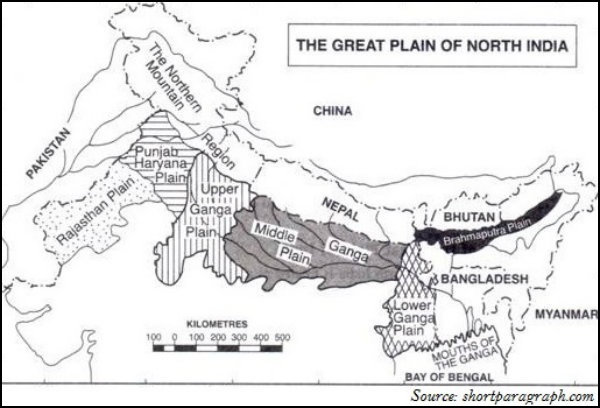
The northern plains are divided into three major zones − the Bhabar, the Tarai, and the alluvial plains.
Bhabar is a narrow belt spread between 8-10 km parallel to the Shiwalik foothills at the break-up of the slope where all the rivers coming through this way deposit heavy materials of rocks and boulders and get disappeared.
These streams again re-emerge in Tarai region.
The south of Tarai is a belt consisting of old and new alluvial deposits known as the Bhangar and Khadar accordingly.
The alluvial plains are further divided as the Khadar and the Bhangar.
Peninsular Plateau
The Peninsular Block is made up of a series of patland plateaus such as the Hazaribagh plateau, the Palamu plateau, the Ranchi plateau, the Malwa plateau, the Coimbatore plateau, and the Karnataka plateau.
Delhi ridge in the northwest, (extension of Aravallis), the Rajmahal hills in the east, Gir range in the west and the Cardamom hills in the south are the peripheral parts of the Peninsular Block.
The Peninsular plateau can be further divided into three broad groups i.e. the Deccan Plateau, the Central Highlands, and the Northeastern Plateau.
Western Ghats is known by different local names. They are known as Sahyadri in Maharashtra; Nilgiri hills in Karnataka and Tamil Nadu; and Anaimalai hills, and Cardamom hills in Kerala.
Located on the Anaimalai hills of the Western Ghats Anaimudi (2,695 m) is the highest peak of Peninsular plateau, followed by Dodabetta (2,637 m) on the Nilgiri hills.
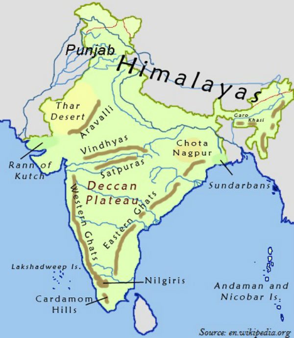
Thal, Bhor, and the Pal Ghats are the important passes of the Western Ghats.
The Eastern Ghats stretch from the Mahanadi Valley in the north to the Nilgiris in the south.
The Eastern Ghats are discontinuous and irregular and dissected by many rivers draining into the Bay of Bengal.
Mahendragiri (1,501 meters) is the highest peak of the Eastern Ghats.
The most distinct feature of the peninsular plateau is the black soil area known as Deccan Trap.
Formed by a series of scarped plateaus on the south, the Satpura range is part of the Central Highlands.
The general elevation of the Central Highlands ranges between 700 and 1,000 m above the mean sea level.
Rajmahal hills and the Meghalaya plateau are the part of the Northeastern Plateau.
The Meghalaya plateau is further sub-divided as the Garo Hills; the Khasi Hills; and the Jaintia Hills.
Meghalaya plateau is rich in mineral resources. The most significant of these resources are coal, iron ore, sillimanite, limestone, and uranium.
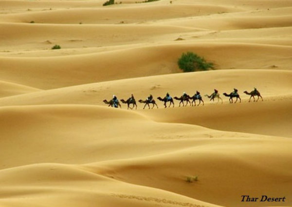
Indian Desert
The Great Indian Desert, also known as the Thar Desert, lies in the northwest of the Aravalli hills.
The Aravali Hills lie on the western and north western margins of the peninsular plateau. These are highly eroded hills and are found as broken hills between Gujarat and Delhi.
Coastal Plains
The Indian coastal plains are divided as the western coastal plains and the eastern coastal plains.
The western coastal plains are an example of submerged coastal plain.
The western coast may be divided into the following divisions − the Kachchh and Kathiawar coast in Gujarat; Konkan coast in Maharashtra; Goan coast in Karnataka, and the Malabar coast in Kerala respectively.
The Malabar Coast has certain distinctive features such as Kayals (backwaters), which are used for fishing, inland navigation, and these backwaters hold a special attraction for the tourists.
In comparison to the western coastal plains, the eastern coastal plain is broader and is an example of an Emergent coast.
The Eastern Coast is named as the Northern Circar (in the north part i.e. part of West Bengal, Odisha, etc.) and the southern part is known as the Coromandel Coast (part of Southern Andhra Pradesh and Tamil Nadu). The eastern coastal plain is known as the Northern Circars in the region between Krishna and Mahanadi rivers (West Bengal, Odisha, etc.) and as the Coromandel Coast in southern part between Krishna and Kaveri rivers (Andhra Pradesh and Tamil Nadu).
Islands
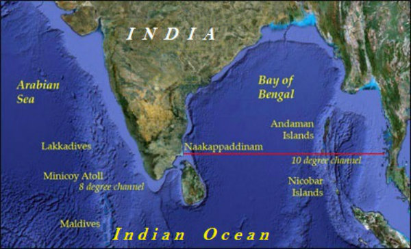
There are two major island groups in India, i.e., one in the Bay of Bengal (Andaman and Nicobar) and the other in the Arabian Sea (Lakshadweep).
The Bay of Bengal island group consists of about 572 islands/islets.
The two principal groups of islets include the Ritchies archipelago and the Labyrinth Islands.
However, the entire group of islands is divided into two broad categories − the Andaman in the north and the Nicobar in the south and they are separated by Ten Degree Channel.
Situated in the Nicobar Islands, Barren Island is the only active volcano in India.
Located on the North Andaman, Saddle peak (738 m) is the highest peak of the region.
Lakshadweep and Minicoy are the islands of the Arabian Sea.
The entire island group of Lakshadweep is built of coral deposits.
There are approximately 36 islands, among which, 11 are inhabited.
The entire group of islands is broadly divided by the Eleventh-degree channel. The Amini Island lies to the north and the Cannanore Island lies to the south of the channel.
Geography India - Drainage System
Introduction
The flow of water through well-defined channels is known as drainage and the network of such channels is known as drainage system.
The drainage pattern of an area is the result of the geological time period, nature, and structure of rocks, topography, slope, etc.
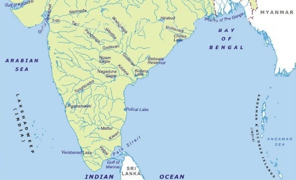
About 77% of the drainage area consisting of the Ganga, the Brahmaputra, the Mahanadi, the Krishna, etc. is oriented towards the Bay of Bengal.
On the other hand, 23% comprising the Indus, the Narmada, the Tapi, the Mahi, and the Periyar systems discharge their waters in the Arabian Sea.
A river drain is a specific area, which is known as the catchment area of that river.
An area drained by a river and its tributaries is known as a drainage basin.
The boundary line separating one drainage basin from the other is called as the watershed area.
Drainage Pattern
Following are the major drainage patterns −
Dendritic
Radial
Centripetal
Trellis
A drainage pattern which looks like tree branches with lots of twigs is known as Dendritic drainage pattern. For example, the rivers of northern plain.
Radial drainage patterns form when rivers originate from a hill and flow in all directions. For example, the rivers originating from the Amarkantak.
Centripetal drainage pattern is formed when rivers discharge their waters from all directions into a lake or a depression. For example, Loktak lake in Manipur.
Trellis drainage pattern is formed when the primary tributaries of main rivers flow parallel to each other and secondary tributaries join them at right angles. For example, rivers in the upper part of the Himalayan region.
Classification of Drainage
On the basis of the mode of origin, nature, and characteristics, the Indian drainage is classified as −
The Himalayan drainage and
The Peninsular drainage.
Himalayan Drainage
Major Himalayan drainage systems are the Indus, the Ganga, and the Brahmaputra rivers.
The Indus
The total length of the Indus River system is 2,880 km (in India 1,114 km).
The Indus, which is also known as the Sindhu, is the westernmost of the Himalayan Rivers in India.
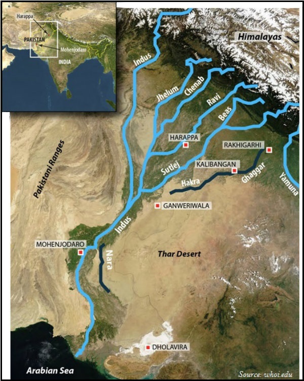
The Indus originates from a glacier near Bokhar Chu in the Tibetan region at an altitude of 4,164 m in the Kailash Mountain range.
In Tibet, the Indus is known as Singi Khamban or the Lions mouth.
The Indus enters into Pakistan near Chillar in the Dardistan region.
Major tributaries of Indus are the Shyok, the Gilgit, the Zaskar, the Hunza, the Nubra, the Shigar, the Gasting, and the Dras in the upper part.
In the lower part, the Satluj, the Beas, the Ravi, the Chenab, and the Jhelum are the major tributaries of the Indus.
Finally, the Indus discharges into the Arabian Sea near Karachi in Pakistan.
The Jhelum, an important tributary of the Indus, rises from a spring at Verinag situated at the foot of the Pir Panjal.
The Jhelum flows through Srinagar and the Wular Lake before entering into Pakistan.
Jhelum joins the Chenab near Jhang in Pakistan.
Formed by two streams i.e. the Chandra and the Bhaga, the Chenab is the largest tributary of the Indus.
Chenab is also known as Chandrabhaga.
The Chenab flows about 1,180 km before entering into Pakistan.
Originating from the Rohtang pass in the Kullu hills of Himachal Pradesh and flowing through the Chamba valley of the state, Ravi is one of the important tributaries of the Indus.
Originating from the Beas Kund near the Rohtang Pass at an elevation of 4,000 m above the mean sea level, Beas is also an important tributaries of the Indus.
Beas enters into the Punjab plains and meets with the Satluj near Harike.
Also popular as Langchen Khambab (in Tibet), the Satluj originates from the Rakas lake near Mansarovar at an altitude of 4,555 m in Tibet.
The Satluj passes through the Shipki La on the Himalayan ranges and enters into the Punjab plains.
The Satluj is the river that feeds the canal system of the Bhakra Nangal project.
The Ganga
The Ganga originates from the Gangotri glacier near Gaumukh (3,900 m) in the Uttarkashi district of Uttarakhand.
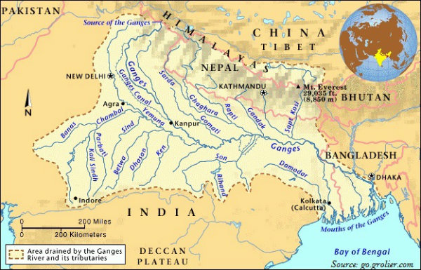
However, the river, when it originates from the Gangotri glacier is known as the Bhagirathi.
At Devprayag, the Bhagirathi merges with another river, i.e., the Alaknanda; and from here, it is known as the Ganga.
The Alaknanda originates from the Satopanth glacier above Badrinath.
The major tributaries of the Alaknanda are the Dhauli and the Vishnu Ganga; these two rivers meet at Joshimath/Vishnu Prayag.
Some other tributaries of the Alaknanda are the Pindar (joins at Karna Prayag), the Mandakini or Kali Ganga (joins at Rudra Prayag).
The total length of the Ganga in India is 2,525 km, which is shared by Uttarakhand (110 km); Uttar Pradesh (1,450 km); Bihar (445 km); and West Bengal (520 km).
The Ganga river system is the largest river system in India.
The Son is a major right bank tributary of the Ganga; however, major left bank tributaries are the Ramganga, the Gomati, the Ghaghara, the Gandak, the Kosi, and the Mahananda.
Originating from the Yamunotri glacier on the western slopes of Banderpunch range (6,316 km), the Yamuna is the longest tributary of the Ganga.
The Yamuna joins the Ganga at Allahabad (Prayag), Uttar Pradesh.
The Chambal, the Sind, the Betwa, and the Kenon are the right bank tributaries of the Yamuna and the Hindan, the Rind, the Sengar, the Varuna, etc. are the left bank tributaries.
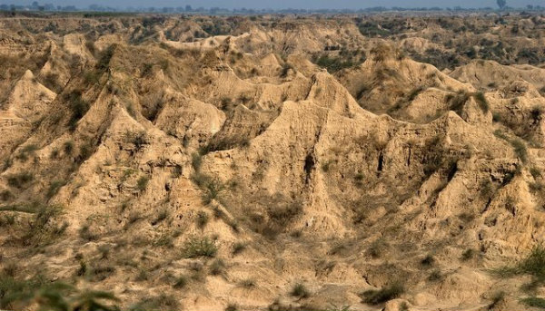
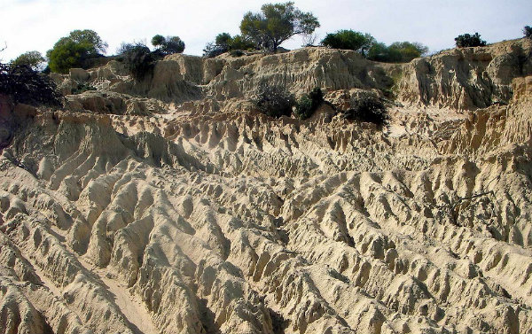
The Chambal rises near Mhow in the Malwa plateau of Madhya Pradesh.
The Chambal is famous for its badland topography, known as the Chambal ravines (as shown in the image given below).
Originating from the Nepal Himalayas between the Dhaulagiri and Mount Everest, the Gandak consists of two streams, namely Kaligandak and Trishulganga.
The Gandak joins the Ganga at Sonpur near Patna, Bihar.
The Ghaghara originates from the Mapchachungo glaciers and joins the Ganga at Chhapra, Bihar.
The Kosi originates from the north of Mount Everest in Tibet where it is known as the Arun.
Originating from the Garhwal hills near Gairsain, the Ramganga joins the Ganga near Kannauj.
The Damodar drains the eastern margins of the Chottanagpur plateau, where it flows through a rift valley and finally joins the Hugli.
The Barakar is the main tributary of the Damodar.
The Sarda or Saryu River rises from the Milam glacier in the Nepal Himalayas where it is known as the Goriganga. However, along the Indo-Nepal border, it is called as Kali or Chauk, where it joins the Ghaghara.
Originating from the Darjeeling hills, the Mahananda joins the Ganga as its last left bank tributary in West Bengal.
Originating from the Amarkantak plateau, the Son is a large south bank tributary of the Ganga; it joins the Ganga at Arrah, Bihar.
The Brahmaputra
The Brahmaputra originates from the Chemayungdung glacier of the Kailash range near the Mansarovar Lake.
In Tibet, the Brahmaputra is known as the Tsangpo (means the purifier).
The Rango Tsangpo is the major right bank tributary of the Brahmaputra in Tibet.
The Brahmaputra enters into India near the west of Sadiya town in Arunachal Pradesh.
Major left bank tributaries of the Brahmaputra are Lohit, Dibang or Sikang, Burhi Dihing, and Dhansari.
Major right bank tributaries of the Brahmaputra are the Subansiri, Kameng, Manas, and Sankosh.
The Tista joins the Brahmaputra on its right bank in Bangladesh and from here, the river is known as the Yamuna.
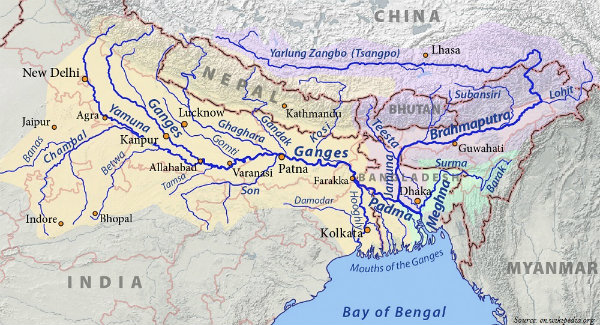
Finally, the Brahmaputra merges with the river Padma and falls in the Bay of Bengal.
Peninsular River System
The Peninsular drainage system is older than the Himalayan Rivers.
The Mahanadi originates from Sihawa in Raipur district of Chhattisgarh and runs through Madhya Pradesh and Odisha and finally discharges its water into the Bay of Bengal.
The total length of Mahanadi is 851 km.
Popularly known as the Dakshin Ganga, the Godavari is the largest peninsular river system.
The Godavari originates from Nasik district of Maharashtra and discharges its water into the Bay of Bengal.
With total 1,465 km length, Godavari covers the areas of Maharashtra, Madhya Pradesh, Chhattisgarh, Odisha, and Andhra Pradesh.
The Penganga, the Indravati, the Pranhita, and the Manjra are the major tributaries of Godavari.
Originating from Mahabaleshwar in Sahyadri, the Krishna is the second largest east flowing Peninsular River.
The Koyna, the Tungabhadra, and the Bhima are the major tributaries of the Krishna.
Of the total catchment area of the Krishna, 27% lies in Maharashtra, 44% in Karnataka, and 29% in Andhra Pradesh.
The Kaveri originates from the Brahmagiri hills (1,341m) located in Kogadu district of Karnataka.
The river Kaveris total course of 770 km commands a basin area of 8.8 million hectare mha, of which, 3% lies in Kerala, 41% lies in Karnataka, and 56% lies in Tamil Nadu.
Major tributaries of the Kaveri are the Kabini, the Bhavani, and the Amravati.
The Narmada originates from the western flank of the Amarkantak plateau (1,057 m).
Flowing through a rift valley located between the Satpura in the south and the Vindhya range in the north, the Narmada forms Dhuandhar waterfall and a picturesque gorge of marble rocks nearby Jabalpur.
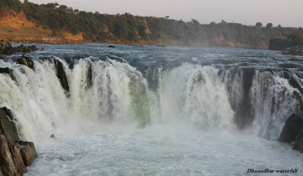
The total length of Narmada is 1,312 km.
Flowing in the westward direction, Narmada finally empties into the Arabian Sea in the Bharuch district of Gujarat.
Originating from Multai in the Betul district of Madhya Pradesh, Tapi is the other important westward flowing river emptying into the Arabian Sea.
About 79% of the Tapi basin lies in Maharashtra, 15% in Madhya Pradesh, and the remaining 6% in Gujarat.
Luni is the longest river system of Rajasthan.
Primarily, Luni originates in the Pushkar valley of the Aravalli range, Rajasthan in two branches, i.e. the Saraswati and the Sabarmati; which join each other at Govindgarh. From here, the river is known as Luni.
Luni finally debouches into the Arabian Sea nearby the Rann of Kachchh.
Some small rivers flowing towards the West are the Shetruniji, the Bhadra, Dhadhar, Sabarmati, Mahi, Vaitarna, Kalinadi, Dedti, Sharavati, Mandovi, Juari, Bharathapuzha, Periyar, etc.
Some small rivers flowing towards the East are Subarnarekha, Baitarni, Brahmani, Penner, and Palar.
The following table illustrates the major differences between Himalayan and the Peninsular River system −
| Characteristics | Himalayan River | Peninsular River |
|---|---|---|
| Place of origin | Himalayan mountains (covered with glaciers). | Peninsular plateau and central highland. |
| Nature of flow | Perennial; receive water from glacier and rainfall. | Seasonal; dependent on monsoon rainfall. |
| Type of drainage | Antecedent and consequent leading to dendritic pattern in plains. | Super imposed, rejuvenated resulting in trellis, radial, and rectangular patterns. |
| Nature of river | Long course, flowing through the rugged mountains experiencing head ward erosion and river capturing; In plains, meandering and shifting off course. | Smaller, fixed course with welladjusted valleys. |
| Catchment area | Very large basin. | Relatively smaller basin. |
| Age of the river | Young and youthful, active and deepening in the valleys | Old rivers with graded profile, and have almost reached their base levels. |
Geography India - Climate
Introduction
Weather is the temporary state of the atmosphere, while climate refers to the average of the weather conditions over a longer period of time.
Weather changes quickly, may be within a day or week, but climate changes in imperceptivity and may be noted after 50, 100 years, or even more.
The climate of India has distinct regional variations discernible by the pattern of winds, temperature, and rainfall; further, also in the form of rhythm of seasons and the degree of wetness or dryness.
Factors Influencing Climate
- Major factors that determine the climate of India are −
- Latitude
- The Himalayan Mountains
- Distribution of land and water
- Distance from the sea
- Altitude
- Relief
Winter
During the winter, north of the Himalayas develops a high pressure center.
This high pressure center gives rise to the flow of air at the low level from the north towards the Indian subcontinent (i.e. south of the mountain range).
All of Western and Central Asia remains under the influence of westerly winds (known as Jet Stream) along the altitude of 9-13 km from west to east.
These winds blow across the Asian continent at the latitudes, north of the Himalayas, roughly parallel to the Tibetan highlands.
However, Tibetan highlands act as a barrier in the path of these jet streams, as a result of this, the jet streams get bifurcated into two branches.
One branch is located to the south of the Himalayas, while the second branch is positioned to the north of Tibetan Plateau.
The western cyclonic disturbances, which enter the Indian subcontinent from the west and the northwest during the winter months, originate over the Mediterranean Sea and are brought into India by the westerly jet stream.
Summer
During the Summer, the wind circulation over the subcontinent undergoes a complete reversal at both, the lower as well as at the upper levels.
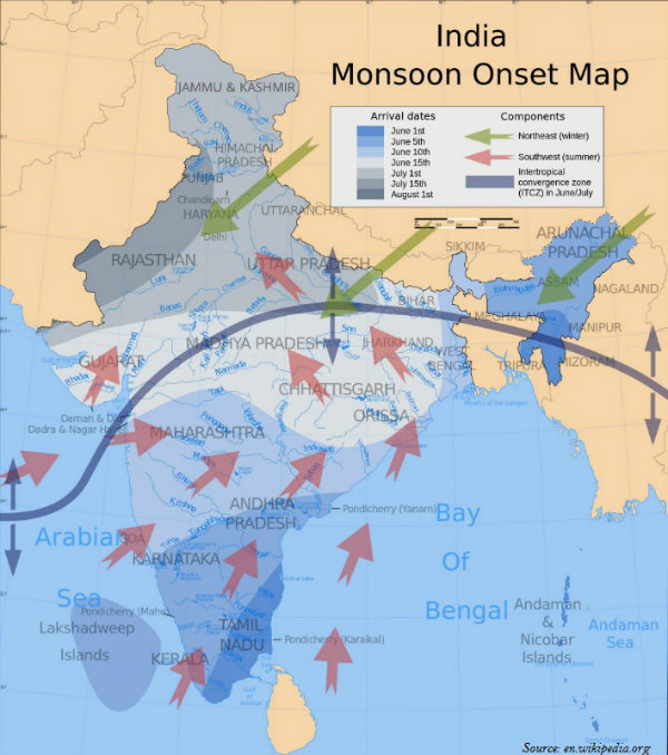
By the middle of July, the low pressure belt nearer the surface [termed as Inter Tropical Convergence Zone (ITCZ)] moves northwards, roughly parallel to the Himalayas between $20^{\circ}N$ and $25^{\circ}N$ (as shown in the image given below).
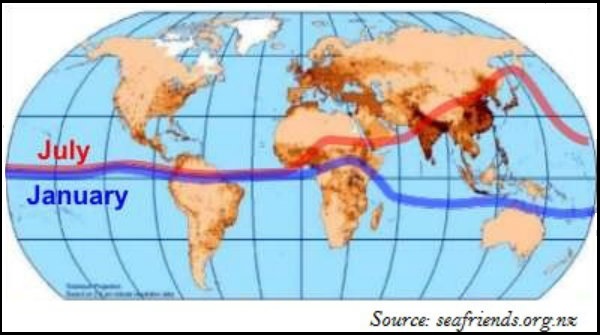
The ITCZ is a zone of low pressure, attracts inflow of winds from different directions.
With the apparent northward movement of the Sun towards the Tropic of Cancer in March, temperatures start rising in north India, which is the sign of advent of Summer season.
April, May, and June are the months of summer in north India.
In the heart of the ITCZ in the northwest, the dry and hot winds known as Loo, blow in the afternoon, and very often, they continue to well into midnight.
Towards the end of the summer, there are pre-monsoon showers, which are a common phenomenon in Kerala and coastal areas of Karnataka. This phenomenon is locally known as mango showers, as it helps in the early ripening of mangoes.
Monsoon
The maritime tropical air mass (mT) from the southern hemisphere crosses the equator and rushes towards the low pressure area; in general, the southwesterly direction.
This moist air current causing rainfall in India is popularly known as the southwest monsoon.
Simultaneously, an easterly jet stream flows over the southern part of the Peninsula in June with a maximum speed of 90 km per hour.
The easterly jet stream steers the tropical depressions into India and these depressions play a significant role in determining the distribution of monsoon rainfall over the Indian subcontinent.
The tracks of these depressions are the areas of the highest rainfall in India.
The southwest monsoon, which is a continuation of the southeast trades, get deflected towards the Indian subcontinent after crossing the Equator.
The easterly jet stream is held responsible for the burst of the monsoon in India.
The southwest monsoon sets first over the Kerala coast by $1^{st}$ of June and then moves swiftly to reach Mumbai and Kolkata between $10^{th}$ and $13^{th}$ June. Further, by mid-July, southwest monsoon engulfs the entire subcontinent.
Southwest monsoon gets divided into two branches − the Arabian Sea, causing rain in western coast of India and the Bay of Bengal branch, causing rain in eastern coast to India.
Generally, the cold weather season sets in by mid-November in northern India.
However, the Peninsular region of India does not have any well-defined cold weather season.
There is hardly any seasonal change in the distribution pattern of the temperature in coastal areas because of the moderating influence of the sea and the proximity to the equator.
Winter monsoons do not cause rainfall, as they move from land to the sea. Hence, primarily, they have little humidity; and secondly, due to anticyclonic circulation on land, the possibility of rainfall from them reduces.
However, in northwestern India, some weak temperate cyclones coming from the Mediterranean Sea (with little moisture) cause rainfall in Punjab, Haryana, Delhi, and western Uttar Pradesh.
On the other hand, during October and November, northeast monsoon while crossing over the Bay of Bengal, picks up moisture and causes torrential rainfall over the Tamil Nadu coast, southern Andhra Pradesh, southeast Karnataka, and southeast Kerala.
Interesting Facts
The shower causing coffee flowers blossom in Kerala and nearby areas is known as blossom shower.
Nor Westers are the dreaded evening thunderstorms in Bengal and Assam.
During the south-west monsoon, the period after having rains for a few days, if rain fails to occur for one or more weeks, it is known as break in the monsoon.
The notorious nature of Nor Westers can be understood from the local nomenclature of Kalbaisakhi, meaning a calamity of the month of Baisakh.
In Assam, Nor Westers are known as Bardoli Chheerha.
Hot, dry, and oppressing winds blowing in the Northern plains from Punjab to Bihar are known as Loo.
The rain in the southwest monsoon season begins rather abruptly.
Sudden onset of the moisture-laden winds associated with violent thunder and lightning, is often termed as the break or burst of the monsoon.
Tamil Nadu coast remains dry during the monsoon season because it is situated parallel to the Bay of Bengal branch of southwest monsoon.
The monsoon rainfall has a declining trend with increasing distance from the sea. For example, Kolkata receives 119 cm, Patna 105 cm, Allahabad 76 cm, and Delhi 56 cm.
The months of October and November are known as retreating monsoons season.
The advent of south-west monsoon is known as advancing monsoon.
As the south-west monsoon passes over the ocean surface (Indian Ocean, Arabian Sea, and Bay of Bengal) it picks up moisture and causes rainfall in India.
Windward side of Western Ghats receives heavy rainfall (more than 250 cm); however, as the distance increases from the sea, the amount and intensity of rainfall start decreasing.
The Bay of Bengal branch of monsoon advances towards the eastern part of India and causes heavy rainfall. North-east India receives heavy rainfall during the monsoon season.
Cherapunji and Mawsynram (two places of Meghalaya) are worlds wettest place.
Though there are great spatial variations in India; the average annual rainfall of India is 125 cm.
The whole of India has a monsoon type of climate, but because of the regional variations, there are various types of climate in India.
Koeppens Climate Classification
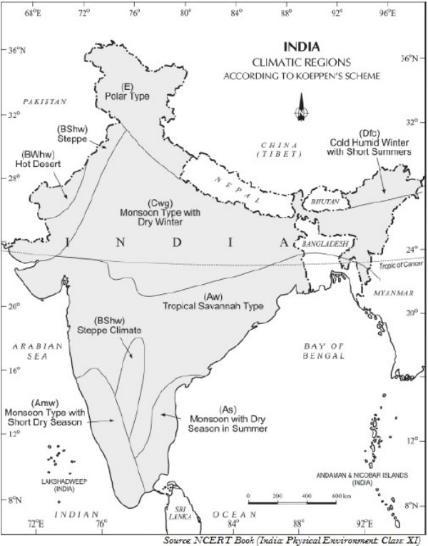
Koeppen, based on his scheme of Climatic classification on monthly values of temperature and precipitation, identified five major climatic types. They are −
Tropical climates
Dry climates
Warm temperate climates
Cool temperate climates
Ice climates
However, the following map (shown below) illustrates the major climatic types of India as classified by Koeppen.
Geography India - Natural Vegetation
Natural vegetation refers to a plant community that has been left undisturbed over a long period of time.
Classification of Vegetation
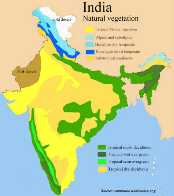
- Based on climatic conditions, forests are divided into categories. They are −
- Tropical Evergreen and Semi Evergreen forests
- Tropical Deciduous forests
- Tropical Thorn forests
- Montane forests
- Littoral and Swamp forests
Tropical Evergreen Forests
Tropical evergreen forests are found in the regions that receive annual precipitation of over 200 cm and mean annual temperature above $22^{\circ}C$.
Tropical evergreen forests are found in the western slope of the Western Ghats, hills of the northeastern region, and the Andaman and Nicobar Islands.
In tropical evergreen forests, trees reach great heights, i.e., up to 60 m or even above. And, largely these trees do not have fixed time to shed their leaves.
Major examples of evergreen forests are rosewood, mahogany, aini, ebony, etc.
Semi-evergreen Forests
Semi-evergreen forests are a mixture of evergreen and moist deciduous trees, found in the regions that receive less precipitation than the evergreen forests.
Main species of semi-evergreen forests are white cedar, hillock, and kail.
Tropical Deciduous Forests
Tropical Deciduous Forests are the most widespread forests of India and are popularly as Monsoon Forests.
Tropical deciduous forests are found in the regions, which receive rainfall between 70 and 200 cm.
Tropical deciduous forests are further categorized as the Moist deciduous forests and Dry deciduous forest.
The moist deciduous forests are found in the regions, which record rainfall between 100 and 200 cm.
The moist deciduous forests are found along the foothills of the Himalayas, eastern slopes of the Western Ghats, and Odisha.
Teak, sal, shisham, hurra, mahua, amla, semul, kusum, and sandalwood etc. are the main species of the moist deciduous forests.
Dry deciduous forests are found in the regions that receive precipitation between 70 and 100 cm.
As the dry season begins, the trees of deciduous forests shed their leaves completely.
Tendu, palas, amaltas, bel, khair, axlewood, etc. are the major trees of dry deciduous forests.
Tropical Thorn Forests
Tropical thorn forests are found in the areas, which receive rainfall less than 50 cm.
Tropical thorn forests are found in the areas of south west Punjab, Haryana, Rajasthan, Gujarat, Madhya Pradesh, and Uttar Pradesh.
Babool, ber, and wild date palm, khair, neem, khejri, palas, etc. are the important species of tropical thorn forests.
Mountain Forests
Mountain forests in India are normally classified into two types, i.e. the northern mountain forests and the southern mountain forests.
Deciduous forests are found in the foothills of the Himalayas.
Temperate forests found between an altitude of 1,000 and 2,000 m.
In the higher hill ranges of northeastern India; for example, hilly areas of West Bengal and Uttaranchal, evergreen broad leaf trees such as oak and chestnut are predominant.
Chir, deodar, pine, etc. are the important species of temperate forests.
Between 3,000 and 4,000 m, Silver firs, junipers, pines, birch, and rhododendrons, etc. are found.
However, at higher altitude, the tundra vegetation is found and major species are mosses and lichens.
At a higher altitude, the southern mountain forests largely belong to the temperate type, which are locally known as Sholas in the Nilgiris, Anaimalai, and Palani hills. Some of the trees of economic significance include magnolia, laurel, cinchona, and wattle.
Littoral and Swamp Forests
India is rich in Littoral and Swamp Forests.
Chilika Lake (in Odisha) and Keoladeo National Park (in Bharatpur, Rajasthan) are protected as water-fowl habitats under the Convention of Wetlands of International Importance (i.e. Ramsar Convention).
Mangrove grows along the coasts in the salt marshes, tidal creeks, mud flats, and estuaries; and, it has a number of salt-tolerant species of plants.
In India, the mangrove forests spread over 6,740 sq. km, which is 7% of the worlds mangrove forests
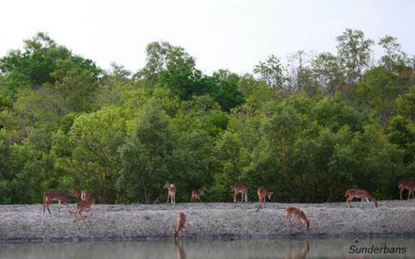
Mangroves are largely found in the Andaman and Nicobar Islands and the Sunderbans of West Bengal.
Geography India - National Forest
Introduction
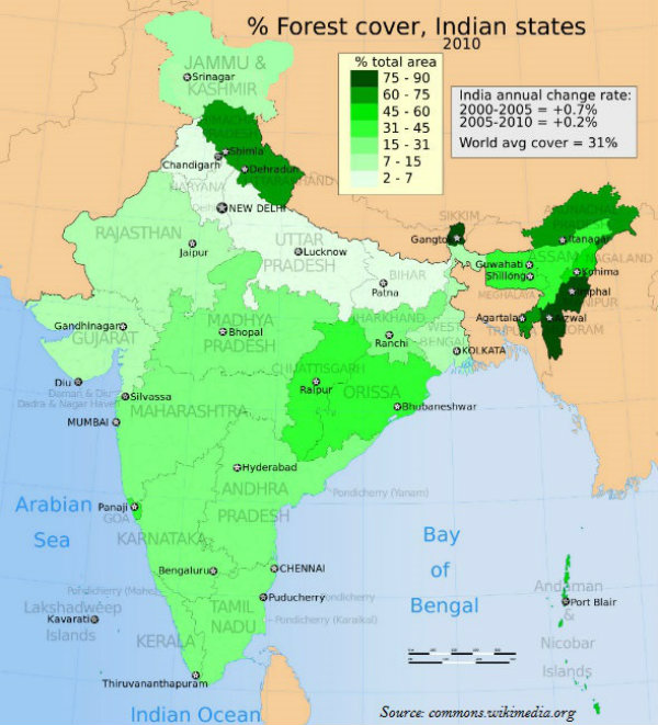
According to the India State of Forest Report 2011, the actual forest cover in India is 21.05%, of which, 12.29% are dense forests and 8.75% are open forests.
Andaman and Nicobar Islands have 86.93% forest area; on the other hand, Lakshadweep has zero per cent forest area [details of forest cover (state-wise) shown in the image given below].
With (about) 90 percent of forest cover, Mizoram has the highest percentage of forest area in India.
Haryana, Punjab, Rajasthan, Uttar Pradesh, Bihar, and Gujarat have less than 10 percent area under forest cover.
Category of National Forest
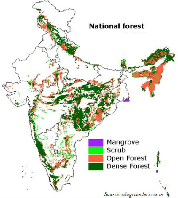
As shown in the map given below, national forest is broadly categorized as Dense Forest, Open Forest, Scrub, and Mangrove.
Currently, there are 102 National parks and 515 wildlife sanctuaries. These collectively cover an area of 15.67 million hectares of India.
The Government of India proposed to have a nation-wide forest conservation policy, and adopted a forest policy in 1952, and further amended in 1988.
Out of a total of 593 districts, 188 districts have been identified as tribal districts.
The tribal districts account for about 59.61% of the total forest cover of India, whereas the geographical area of 188 tribal districts constitutes only 33.63% of the total geographical area of India.
Social Forestry
For the forest conservation and increase the forest area, the concept of Social forestry has been introduced.
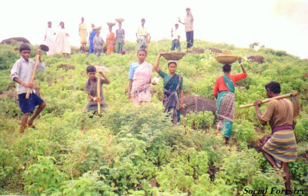
Social Forestry means the management and protection of forests and afforestation on barren lands with the purpose of helping in the environmental, social, and rural development.
Further, in 1976, The National Commission on Agriculture has classified social forestry into three categories i.e. Urban forestry, Rural forestry, and Farm forestry.
Farm forestry is a term applied to the process under which the farmers grow trees for commercial and non-commercial purposes on their farm lands.
Geography India - Wildlife
Introduction
India is one of the $12^{th}$ mega bio-diversity countries of the world.
With approximately 47,000 plant species, India ranks $4^{th}$ in Asia and $10^{th}$ in the world (in terms of plant diversity).
India has about 15,000 species of flowering plants and contributes 6 percent to worlds total flowering plants.
India has about 90,000 species of animals.
Wildlife Act
In 1972, a comprehensive Wildlife Act was enacted, which instructed the main legal framework for conservation and protection of the wildlife in India.
Further, in 1991, the Act of 1972 has been comprehensively amended.
In the amendment, punishments have been made more stringent and provisions have also been made for the protection of specified plant species and conservation of endangered species of wild animals.
Besides, some other special schemes such as Project Tiger (1973) and Project Elephant (1992) have been launched to conserve these species and their habitats.
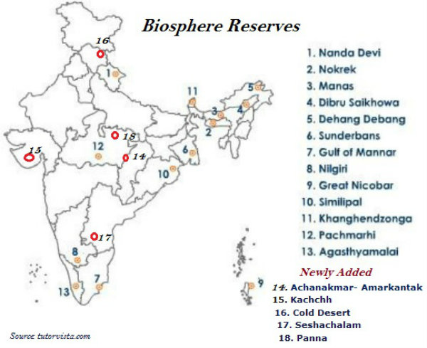
Biosphere Reserve
A Biosphere Reserve is a unique and representative ecosystem of terrestrial and coastal areas, which are internationally recognized within the framework of UNESCOs Man and Biosphere (MAB) Program.
There are 18 Biosphere Reserves in India, out of which 9 Biosphere Reserves have been recognized by the UNESCO on World Network of Biosphere Reserves.
Established in September 1986, the Nilgiri Biosphere Reserve is the first biosphere reserves of India.
There are about 2,000 species of birds in India that account to 13 percent of the worlds total.
There are about 2,546 species of fish in India that account to 12 percent of the worlds total.
India has about 5 to 8 percent of the worlds amphibians, reptiles, and mammals.
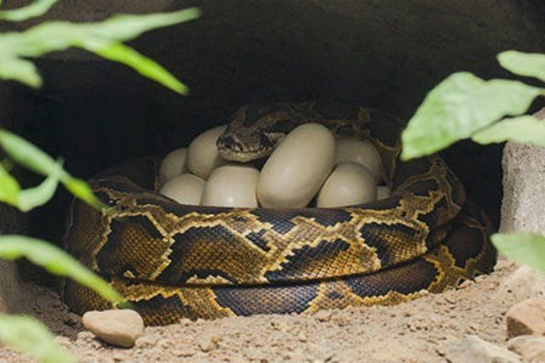
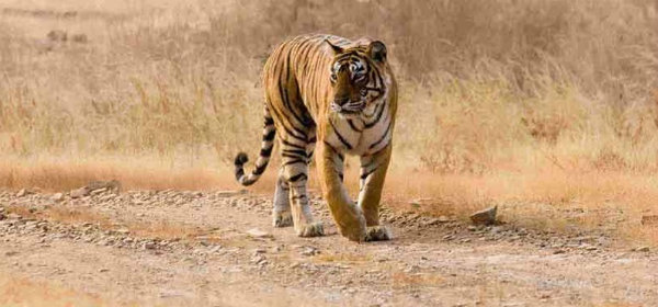
India is the only country in the whole world where both tigers and lions are found.
Gir forest in Gujarat is the natural habitat of lion in India.
Tigers are found in the Sundarbans of West Bengal, and the forests of Madhya Pradesh and Himalayan region.
About 1,300 plant species have been listed as endangered species in India; however, 20 species are already extinct.
The threat on wildlife has increased because of excessive commercial activities, pollution, expansion of human settlement, and of course illegal trade of both animals and plants.
To protect wildlife, the Government of India has established 18 biosphere reserves; (list with details is given below − the data is prepared by the Ministry of Environment, Forest and Climate Change, Government of India) −
| S.No. | Name of the Biosphere Reserve & total geographical area ($Km^{2}$) | Date of Designation | Location |
|---|---|---|---|
| 1 | Nilgiri (5520) | 01.08.1986 | Part of Wynad, Nagarhole, Bandipur and Madumalai, Nilambur, Silent Valley and Siruvani hills in Tamil Nadu, Kerala and Karnataka. |
| 2 | Nanda Devi (5860.69) | 18.01.1988 | Part of Chamoli, Pithoragarh and Almora districts in Uttarakhand. |
| 3 | Nokrek (820) | 01.09.1988 | Part of East, West and South Garo Hill districts in Meghalaya. |
| 4 | Manas (2837) | 14.03.1989 | Part of Kokrajhar, Bongaigaon, Barpeta, Nalbari, Kamprup and Darang districts in Assam |
| 5 | Sunderban (9630) | 29.03.1989 | Part of delta of Ganges & Brahamaputra river system in West Bengal. |
| 6 | Gulf of Mannar (10500) | 18.02.1989 | Indian part of Gulf of Mannar extending from Rameswaram island in the North to Kanyakumari in the South of Tamil Nadu. |
| 7 | Great Nicobar (885) | 06.01.1989 | Southernmost island of Andaman and Nicobar Islands. |
| 8 | Similipal (4374) | 21.06.1994 | Part of Mayurbhanj district in Odisha. |
| 9 | Dibru-Saikhova (765) | 28.07.1997 | Part of Dibrugarh and Tinsukia districts in Assam. |
| 10 | Dehang-Dibang (5111.5) | 02.09.1998 | Part of Upper Siang, West Siang and Dibang Valley districts in Arunachal Pradesh. |
| 11 | Pachmarhi (4981.72) | 03.03.1999 | Part of Betul, Hoshangabad and Chhindwara districts in Madhya Pradesh. |
| 12 | Khangchendzonga (2931.12) | 07.02.2000 | Part of North and West districts in Sikkim. |
| 13 | Agasthyamalai (3500.36) | 12.11.2001 | Part of Thirunelveli and Kanyakumari districts in Tamil Nadu and Thiruvanthapuram, Kollam and Pathanmthitta districts in Kerala. |
| 14 | Achanakmar - Amarkantak (3,835. 51) | 30.03.2005 | Part of Anuppur and Dindori districts of Madhya Pradesh and Bilaspur district of Chattisgarh. |
| 15 | Kachchh (12,454) | 29.01.2008 | Part of Kachchh, Rajkot, Surendranagar and Patan districts in Gujarat. |
| 16 | Cold Desert (7,770) | 28.08.2009 | Pin Valley National Park and surroundings; Chandratal & Sarchu; and Kibber Wildlife sanctuary in Himachal Pradesh. |
| 17 | Seshachalam (4755.997) | 20.09.2010 | Seshachalam hill ranges in Eastern Ghats encompassing part of Chittoor and Kadapa districts in Andhra Pradesh. |
| 18 | Panna (2998.98) | 25.08.2011 | Part of Panna and Chhattarpur districts in Madhya Pradesh. |
The above highlighted reserves have been included in the World Network of Biosphere Reserves of UNESCO.
Nanda Devi in Uttarakhand, Sunderbans in the West Bengal, the Gulf of Mannar in Tamil Nadu, the Nilgiris between the states of Tamil Nadu, Kerala, and Karnataka, etc. have been included in the world network of Biosphere reserves.
The plant species grown naturally without any human aid and remains undisturbed is known as virgin vegetation.
The virgin vegetation, which are purely originated and grown in India is known as endemic or indigenous species but those which have come from outside India are termed as exotic plants.
Flora simply refers to plant species and Fauna refers to animal species.
Geography India - Soil
Introduction
Soil is very important and a valuable resource for every human being.
Soil is the mixture of rock debris and organic materials, which develop on the earths surface.
The major factors that determine soils characteristics are parent material, climate, relief, vegetation, time, and some other life-forms.
Major constituents of the soil are mineral particles, humus, water, and air.
A soil horizon is a layer generally parallel to the soil crust, whose physical characteristics differ from the layers above and beneath.
Soil Profile
Soil Horizon is classified into three categories − Horizon A, Horizon B, and Horizon C; collectively known as Soil Profile (i.e. the arrangement of soil layers).
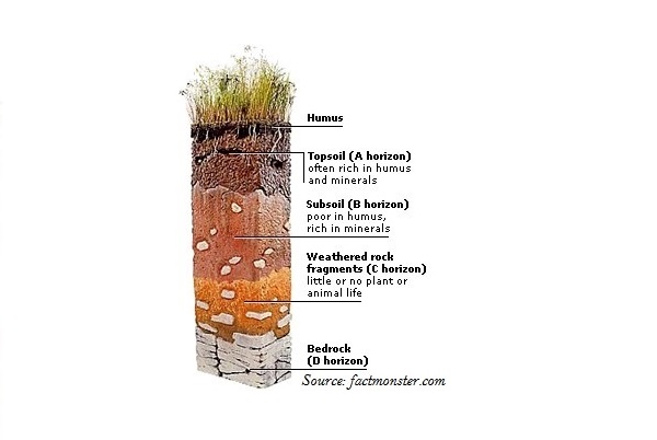
Horizon A is the topmost zone, where organic materials stored with the minerals, nutrients, and water, necessary for the growth of the plants.
Horizon B is the transition zone between the horizon A and horizon C, and hence, it contains matter derived from horizon A as well as from horizon C.
Horizon C is composed of loose parent material and hence, it is the layer of first stage of the soil formation process and eventually forms the above discussed two layers.
Classification of Soil
Soils were classified on the basis of their inherent characteristics and external features including texture, color, slope of land, and moisture content in the soil.
Soil Survey of India, established in 1956, made comprehensive study of soils.
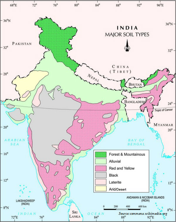
On the basis of genesis, color, composition, and location, the soils of India have been classified as −
Alluvial soils
Black soils
Red and Yellow soils
Laterite soils
Arid soils
Forest soils
Saline soils
Peaty soils.
Alluvial Soils
Alluvial soils are widespread in the northern plains and the river valleys and cover about 40% of total area of India.
Alluvial soils are depositional soils, as transported and deposited by the rivers streams.
Alluvial soils are normally rich in potash, but poor in phosphorous.
In the Upper and Middle Ganga plain, two different types of alluvial soils are found i.e. Khadar (it is the new alluvium and is deposited by floods annually) and Bhangar (it is a system of older alluvium, deposited away from the flood plains).
The alluvial soils normally vary in nature from sandy, loamy, to clayey and its color varies from light grey to ash grey.
Black Soils
Also popular as Regur Soil or the Black Cotton Soil, Black soil covers most of the Deccan Plateau; for example, black soil is found in parts of Maharashtra, Madhya Pradesh, Gujarat, Andhra Pradesh, and Tamil Nadu.
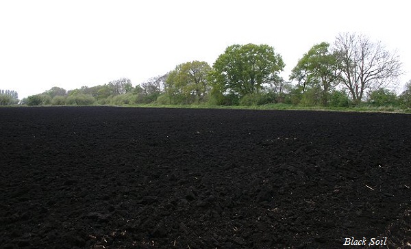
Black soil is usually clayey, deep, and impermeable; therefore, it can retain the moisture for a very long time (very useful for the crops especially cotton).
Black soil is rich in lime, iron, magnesia, alumina, and also potash.
The color of the black soil varies from deep black to grey.
Red & Yellow Soils
Red soil develops on crystalline igneous rocks in the areas of low rainfall, especially, in the eastern and southern parts of the Deccan Plateau.
Red soil develops a reddish color because of a wide diffusion of iron in crystalline and metamorphic rocks. On the other hand, it develops yellow color when it occurs in a hydrated form.
The fine-grained red and yellow soils are usually fertile, whereas coarse-grained soils found in dry upland areas have poor fertility.
The red and yellow soils normally have poor content of nitrogen, phosphorous and humus.
Laterite Soils
The laterite soils develop in areas of high temperature and high rainfall.
The laterite soils are commonly found in Karnataka, Kerala, Tamil Nadu, Madhya Pradesh, and the hilly areas of Odisha and Assam.
Laterite soils are the result of intense leaching due to tropical rains; because of rain, lime and silica are leached away, and soils become rich in iron oxide and aluminum.
Laterite soils however are poor in organic matter, nitrogen, phosphate, and calcium, but rich in iron oxide and potash.
Laterite soils are normally infertile; however, it is widely to make bricks (used in building construction).
Normally sandy in structure and saline in nature, arid soils vary from red to brown in color.
Arid Soils
Lower horizons of the arid soils are occupied by kankar layers because of the increasing calcium content downwards.
Arid soils have poor content of humus and organic matter.
Arid soils are typically developed in western Rajasthan.
Saline Soils
Saline soils contain a larger proportion of sodium, potassium, and magnesium, and thus, they are infertile, and do not support vegetation.
Because of the dry climate and poor drainage system, saline soil contains more salt.
Saline soils are normally found in arid and semi-arid regions, as well as in waterlogged and swampy areas.
Deficient in nitrogen and calcium, saline soils are found in western Gujarat, deltas of the eastern coast, and in Sunderban areas of West Bengal.
Forests Soils
Forest soils are usually formed in the forest areas where sufficient rainfall is available.
Like other organism, soils are living systems, as they too develop and decay, get degraded, and respond to proper treatment if administered in time.
Peaty Soils
In the areas of heavy rainfall and high humidity, large quantity of dead organic matter accumulates and enrich humus and organic content that forms the peaty soils.
Peaty soils are normally heavy and black in color and widely found in the northern part of Bihar, southern part of Uttaranchal, and the coastal areas of West Bengal, Odisha, and Tamil Nadu.
Decline in soil fertility because of any reason (either natural or human induced) is known as soil degradation (example shown in the image given below).
Geography India - Land Resources
Introduction
Land use record is maintained by the Land Revenue Department.
The Survey of India is accountable for measuring geographical area of administrative units in India.
There is difference between the actual forest area and the forest area defined by the Government.
Categories of Land
Land under settlements (i.e. rural and urban), infrastructure (i.e. roads, canals, industries, shops, etc.) are kept under the category of Non-Agricultural Land.
Barren hilly terrains, desert lands, ravines, etc. normally are not suitable for cultivation, hence, they are known as Barren and Wastelands.
The land owned by the village panchayat comes under Common Property Resources.
Any land, which is left fallow (uncultivated) for more than five years is categorized as Culturable Wasteland.
The land, which is left without cultivation for one or less than one agricultural year is known as Current Fallow.
The physical extent of the land on which crops are sown and harvested is known as Net Sown Area.
Land use pattern changes with time and the nature of economic activities carried out in that region.
As a result of increase in population, change in income levels, available technology, and associated factors, pressure on land increases and marginal lands come under use.
When secondary and tertiary sectors grow much faster than primary sector, then agricultural land changes into non-agricultural land.
Likewise, India has undergone major changes within the economy over the past four or five decades, and it has influenced the land-use changes in the country.
Because of the changing structure of the Indian economy, the rate of increase of non-agricultural land is very fast.
Geography India - Agriculture
Introduction
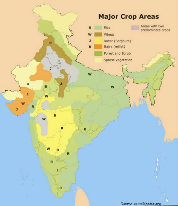
There are three distinct cropping seasons in the northern and interior parts of India, namely kharif, rabi, and zaid.
| Cropping Season | Major Crops Cultivated | |
|---|---|---|
| Northern States | Southern States | |
| Kharif (June-September) | Rice, Cotton, Bajra, Maize, Jowar, Toor | Rice, Maize, Ragi, Jowar, Groundnut |
| Rabi (October March) | Wheat, Gram, Rapeseeds, and Mustard, Barley | Rice, Maize, Ragi, Groundnut, Jowar |
| Zaid (AprilJune) | Vegetables, Fruits, Fodder | Rice, Vegetables, Fodder |
Dryland farming is largely restricted to the regions having annual rainfall less than 75 cm. Major crops are ragi, bajra, moong, gram, and guar (fodder crops).
The regions, which have rainfall in excess of soil moisture requirement of plants during the rainy season is known as wetland farming. Major crops are rice, jute, and sugarcane.
The cereals occupy about 54% of total cropped area in India.
India produces about 11% cereals of the world and ranks 3rd in production after China and U.S.A.
Indian cereals are classified as fine grains (e.g. rice, wheat, etc.) and coarse grains (e.g. jowar, bajra, maize, ragi, etc.).
Types of Farming
On the basis of main source of moisture for crops, the farming can be classified as irrigated and rainfed.
On the basis of adequacy of soil moisture during cropping season, rainfed farming is further classified as dryland and wetland farming.
Major Crops
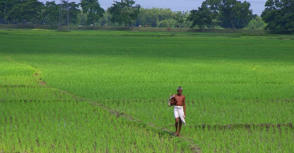
In southern states and West Bengal, the climatic conditions facilitate the cultivation of two or three crops of rice in an agricultural year.
In West Bengal farmers grow three crops of rice called aus, aman, and boro.
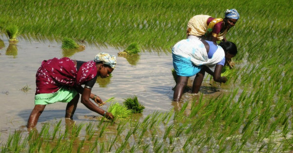
India contributes more than 20% to worlds rice production and ranks 2nd after China.
About one-fourth of the total cropped area of India is under rice cultivation.
West Bengal, Punjab, and Uttar Pradesh are the leading rice producing states.
India produces about 12% of total wheat production of the world.
About 85% of total area under this crop is concentrated in north and central regions of the country, i.e., the Indo-Gangetic Plain, Malwa Plateau, and the Himalayan regions especially up to 2,700 m altitude.
About 14% of the total cropped area in the country is under wheat cultivation.
Uttar Pradesh, Punjab, Haryana, Rajasthan, and Madhya Pradesh are wheat producing states.
The coarse cereals together occupy about 16.50% of total cropped area in the country.
Maharashtra alone contributes to more than half of the total jowar production of the country.
Bajra occupies about 5.2% of total cropped area in the country.
Maharashtra, Gujarat, Uttar Pradesh, Rajasthan, and Haryana are the leading Bajra producer states.
Maize is a food as well as fodder crop grown under the semi-arid climatic conditions and over inferior soils.
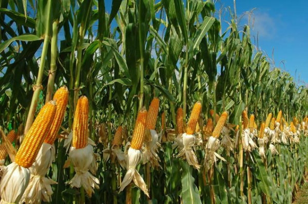
Maize occupies about 3.6% of the total cropped area of India.
Madhya Pradesh, Andhra Pradesh, Telangana, Karnataka, Rajasthan, and Uttar Pradesh are the leading maize producers in the country.
Pulses are the legume crops, which increase the natural fertility of soils through nitrogen fixation.
With one-fifth of the total production of pulses in the world, India is a leading producer.
Pulses occupy about 11% of the total cropped area in the country.
The cultivation of pulses in the country is largely concentrated in the drylands of Deccan and central plateaus and northwestern parts.
Gram and Toor are the main pulses cultivated in India.
Gram covers only about 2.8% of the total cropped area in the country.
Madhya Pradesh, Uttar Pradesh, Maharashtra, Andhra Pradesh, Telangana, and Rajasthan are the main producers of gram.
Toor (Arhar) is also known as red gram or pigeon pea.
Toor occupies only about 2% of total cropped area of India.
Maharashtra alone contributes to about one-third of the total production of toor.
Groundnut, rapeseed and mustard, soyabean, and sunflower are the main oilseed crops grown in India.
Oilseeds occupy about 14% of total cropped area in the country.
Drylands of Malwa plateau, Marathwada, Gujarat, Rajasthan, Telangana, Rayalseema region of Andhra Pradesh and Karnataka plateau are the major oilseeds growing regions of India.
India produces about 18.8% of the total groundnut production in the world.
Groundnut covers about 3.6% of total cropped area in the country.
Gujarat, Tamil Nadu, Telangana, Andhra Pradesh, Karnataka, and Maharashtra are the leading groundnut producer states in India.
Rapeseed and mustard comprise several oilseeds such as rai, sarson, toria, and taramira.
Rapeseed and mustard oilseeds together occupy only 2.5% of total cropped area in the country.
Rajasthan alone contributes to about one-third production (of oilseeds) while Uttar Pradesh, Haryana, West Bengal, and Madhya Pradesh other leading producers.
Sunflower cultivation is concentrated in the regions of Karnataka, Andhra Pradesh, Telangana, and adjoining areas of Maharashtra.
India grows both the short staple (Indian) cotton as well as the long staple (American) cotton called narma in north-western parts of the country.
India accounts to about 8.3% of worlds total production of cotton.
India ranks $4^{th}$ in the world for production of cotton after China, U.S.A., and Pakistan.
Cotton occupies about 4.7% of total cropped area in the country.
The major cotton growing areas in India are parts of Punjab, Haryana, and northern Rajasthan in the north-west; Gujarat and Maharashtra in the west; and plateaus of Andhra Pradesh, Karnataka, and Tamil Nadu in the south.
Maharashtra, Gujarat, Andhra Pradesh, Punjab, and Haryana are the leading cotton producing states.
India produces about three-fifth of the total jute production of the world.
West Bengal contributes about three-fourth of the total production of jute in the country.
India is the second largest producer of sugarcane after Brazil.
Sugarcane occupies 2.4% of total cropped area in the country and contributes about 23% to the worlds production of sugarcane.
Uttar Pradesh produces about two-fifth of sugarcane of the country; other leading producers are Maharashtra, Karnataka, Tamil Nadu, Telangana, and Andhra Pradesh.
Tea is a plantation crop and used as a major beverage in India.
Black tea leaves are fermented whereas green tea leaves are not fermented.
Tea leaves have rich content of caffeine and tannin.
Tea is grown over the undulating topography of hilly areas and well drained soils in humid and sub-humid tropics and sub-tropics.
In India, tea plantation started in 1840s in the Brahmaputra valley of Assam, which still is a major tea growing area in the country.
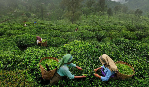
With 28% of the worlds total production, India is a leading producer of tea.
India ranks third among tea exporting countries in the world after Sri Lanka and China.
Assam accounts for about 53.2% of the total cropped area and contributes more than half of total production of tea in the country; West Bengal, and Tamil Nadu are the other leading tea producers.
There are three varieties of coffee − arabica, robusta, and liberica.
India generally grows superior quality of coffee i.e. arabica, which is in great demand in the International market
India produces only about 3.2% coffee of worlds total production and ranks 7th after Brazil, Vietnam, Colombia, Indonesia, Ethiopia, and Mexico.
Coffee in India is cultivated in the highlands of the Western Ghats in the states of Karnataka, Kerala, and Tamil Nadu.

Karnataka alone contributes more than two-third to the total production of coffee in India.
New seed varieties of wheat (from Mexico) and rice (from Philippines) known as high yielding varieties (HYVs) were introduced during mid-1960s in India (Green Revolution).
Agricultural Problems
About 57% of the land is covered by crop cultivation in India; however, in the world, the corresponding share is only about 12%.
On the other hand, the land-human ratio in the country is only 0.31 ha, which is almost half of that of the world as a whole i.e. 0.59 ha.
However, major problems of the Indian agriculture system are −
Dependence on erratic monsoon;
Low productivity;
Constraints of financial resources and indebtedness;
Lack of proper land reforms;
Small farm size and fragmentation of landholdings;
Lack of commercialization; under-employment; and
Degradation of cultivable land.
Further, lack of development of rural infrastructure, withdrawal of subsidies and price support, and impediments in availing of the rural credits may lead to interregional and inter-personal disparities in rural areas.
Intensive Agricultural District Program (IADP) and Intensive Agricultural Area Program (IAAP) were launched to overcome the agricultural problems in India.
Planning Commission of India initiated agro-climatic planning in 1988 to induce regionally balanced agricultural development in the country.
Geography India - Mineral Resources
Introduction
On the basis of chemical and physical properties, minerals are grouped as −
Metallic minerals and
Non-metallic minerals.
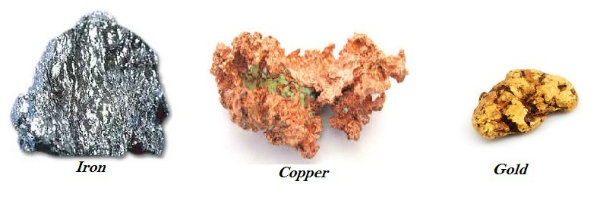
Major examples of metallic minerals are iron ore, copper, gold, etc.
Metallic minerals are further sub-divided as ferrous and non-ferrous metallic minerals.
The minerals containing iron is known as ferrous and without iron is known as non-ferrous (copper, bauxite, etc.).
Depending upon the origination, non-metallic minerals are either organic (such as fossil fuels also known as mineral fuels, which are derived from the buried animal and plant, e.g. such as coal and petroleum), or inorganic minerals, such as mica, limestone, graphite, etc.
Distribution of Minerals
Minerals are unevenly distributed on the earths surface.
All minerals are exhaustible in nature, i.e., will exhaust after a certain time.
However, these minerals take long time to form, but they cannot be replenished immediately at the time of need.
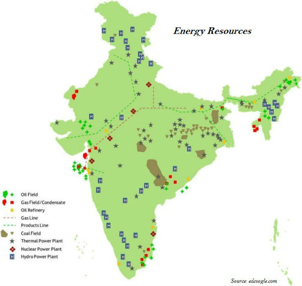
More than 97% of coal reserves occur in the valleys of Damodar, Sone, Mahanadi, and Godavari rivers.
Petroleum reserves in India are located in the sedimentary basins of Assam, Gujarat, and Mumbai High (i.e. off-shore region in the Arabian Sea shown in the map given below).
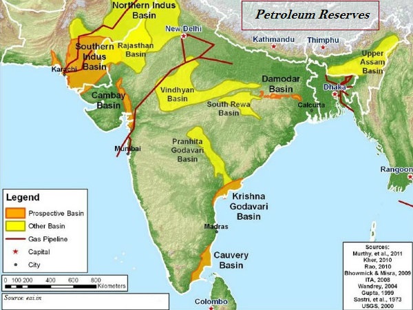
Some new petroleum reserves are also found in the Krishna-Godavari and Kaveri basins (shown in the image given above).
Mineral Belts in India
Further, there are three major mineral belts in India namely −
The North-Eastern Plateau Region,
The South-Western Plateau Region, and
The North-Western Region.
North-Eastern Plateau Region
The major areas of north-eastern plateau region are Chhotanagpur (Jharkhand), Odisha, West Bengal, and parts of Chhattisgarh.
Iron ore, coal, manganese, bauxite, and mica are the major minerals of the north-eastern plateau region.
South-Western Plateau Region
The south-western plateau region covers major parts of Karnataka, Goa, and contiguous Tamil Nadu uplands and Kerala.
Major mineral resources of south-western plateau region are iron ore, manganese, and limestone.
Kerala has deposits of monazite and thorium, and bauxite clay and Goa has deposits of iron ore.
North-Western Region
The north-western region covers the areas of Aravalli in Rajasthan and parts of Gujarat.
Major minerals of north-western regions are copper and zinc; other significant minerals include sandstone, granite, and marble, along with Gypsum and Fullers earth deposits.
In addition, Gujarat and Rajasthan, both have rich sources of salt.
The Himalayan belt is also an important mineral belt, as it has rich deposits of copper, lead, zinc, cobalt, and tungsten.
Major Minerals
Following are the major minerals found in india −
Iron
About 95% of total reserves of iron ore is found in the States of Odisha, Jharkhand, Chhattisgarh, Karnataka, Goa, Telangana, Andhra Pradesh, and Tamil Nadu.
Sundergarh, Mayurbhanj, and Jhar are the major iron ore regions in Odisha and the important mines are Gurumahisani, Sulaipet, Badampahar (Mayurbhaj), Kiruburu (Kendujhar), and Bonai (Sundergarh).
Noamundi (Poorbi Singhbhum) and Gua (Pashchimi Singhbhum) are important mines in Jharkhand.
Dalli and Rajhara in Durg district are the important mines of Chhattisgarh.
Sandur-Hospet area of Ballari district, Baba Budan hills, and Kudremukh in Chikkamagaluru district, and parts of Shivamogga are the important iron ore regions in Karnataka.
The districts of Chandrapur, Bhandara, and Ratnagiri are the iron regions in Maharashtra.
Other iron ore regions in India are Karimnagar and Warangal district of Telangana, Kurnool, Cuddapah, and Anantapur districts of Andhra Pradesh, and Salem and Nilgiris districts of Tamil Nadu.
Manganese
Odisha is the leading producer of Manganese.
Bonai, Kendujhar, Sundergarh, Gangpur, Koraput, Kalahandi, and Bolangir are the major manganese regions in Odisha.
Dharwar, Ballari, Belagavi, North Canara, Shivamogga, Chitradurg, Tumkur, and Chikkmagaluru are major manganese regions in Karnataka.
Nagpur, Bhandara, and Ratnagiri districts are the major regions of manganese in Maharashtra.
Balaghat-Chhindwara-Nimar-Mandla, and Jhabua districts are the important manganese regions of Madhya Pradesh.
Bauxite
Odisha is the largest producer of Bauxite in India.
Kalahandi, Sambalpur, Bolangir, and Koraput are the leading producers of bauxite in Odisha.
Lohardaga (Jharkhand) is rich in bauxite deposits.
Amarkantak plateau has rich deposits of bauxite in Chhattisgarh.
Katni-Jabalpur area and Balaghat are the major regions of bauxite in Madhya Pradesh.
Kolaba, Thane, Ratnagiri, Satara, Pune, and Kolhapur in Maharashtra are important bauxite producers.
Copper
Copper deposits are largely concentrated in Singhbhum district of Jharkhand, Balaghat district of Madhya Pradesh, and Jhunjhunu and Alwar districts of Rajasthan.
Mica
Hazaribagh plateau of Jharkhand and Nellore district of Andhra Pradesh have deposits of high grade mica.
Jaipur to Bhilwara and areas around Udaipur are the major mica-bearing regions of Rajasthan.
Other mica-bearing regions are Mysore and Hasan districts of Karnataka; Coimbatore, Tiruchirapalli, Madurai, and Kanniyakumari of Tamil Nadu; Alleppey of Kerala; Ratnagiri of Maharashtra; Purulia and Bankura of West Bengal.
Geography India - Energy Resources
Introduction
Major sources of energy in India are classified as −
Conventional sources (e.g. coal, petroleum, and nuclear power).
Non-conventional sources (e.g. solar energy, hydro energy, geo-thermal energy, etc.)
Fossil fuel or conventional sources of energy are found exhaustible in nature and also not environmental friendly; on the other hand, the non-conventional sources of energy such as solar energy, wind energy, geo-thermal energy, tidal energy, etc. are renewable sources of energy and they are also environmental friendly (as they do not pollute environment).
Coal
About 80% of the coal deposits in India is of bituminous type and is of non coking grade.
The most important Gondwana coal fields of India are located in Damodar Valley region.
Raniganj, Jharia, Bokaro, Giridih, and Karanpura are major coalfields of Jharkhand-Bengal coal belt.

Jharia is the largest coal field followed by Raniganj.
Other important coal mines are Singrauli (partially in Madhya Pradesh and partially in Uttar Pradesh); Korba in Chhattisgarh; Talcher and Rampur in Odisha; ChandaWardha, Kamptee, and Bander in Maharashtra; Singareni in Telangana; and Pandur in Andhra Pradesh.
Tertiary coalfields are largely located in Darangiri, Cherrapunji, Mewlong, and Langrin in Meghalaya; Makum, Jaipur, and Nazira in upper Assam; Namchik Namphuk in Arunachal Pradesh; and Kalakot in Jammu and Kashmir.
The brown coal or lignite are found in the coastal areas of Tamil Nadu, Pondicherry, Gujarat, and Jammu and Kashmir.
Petroleum
Hydrocarbons of liquid and gaseous states varying in chemical composition, color, and specific gravity are collectively known as petroleum resource.
Petroleum industries produce various by-products; for example, fertilizer, synthetic rubber, synthetic fiber, medicines, vaseline, lubricants, wax, soap, and cosmetics.
Crude petroleum normally occurs in sedimentary rocks of the tertiary period.
For the systematic oil exploration and production, the Oil and Natural Gas Commission was set up in 1956.
Digboi, Naharkatiya, and Moran are important oil producing areas in Assam.
Ankaleshwar, Kalol, Mehsana, Nawagam, Kosamba, and Lunej are the major petroleum producing regions in Gujarat.
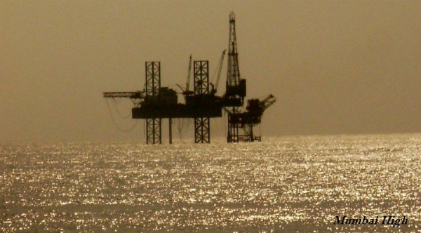
Located 160 km off Mumbai, Mumbai high, an offshore oilfield was discovered in 1973. Production of petroleum at the field was started in 1976.
Krishna-Godavari and Kaveri basin on the east coast are significant regions of petroleum production.
Oil extracted from the wells remains in crude oil form and contains many impurities; hence, it needs to be extracted in oil refineries.
Based on destination, there are two types of oil refineries oil-field based (e.g. Digboi) and market based (Barauni).
To transport and develop the market for natural gas, the Gas Authority of India Limited was set up in 1984 (it is a public sector undertaking).
Though natural gas reserves have been located along the petroleum reserves, but some exclusive natural gas reserves are found along the eastern coast of Tamil Nadu, Odisha, and Andhra Pradesh; as well as around Tripura, Rajasthan, and off-shore wells in Gujarat and Maharashtra.
Nuclear Energy
Essential minerals used for the generation of nuclear energy are uranium and thorium.
Geographically, uranium ores are found at many different locations along the Singbhum Copper belt.
Other important uranium reserve regions are also found in Udaipur, Alwar, and Jhunjhunu districts of Rajasthan; Durg district of Chhattisgarh; Bhandara district of Maharashtra; and Kullu district of Himachal Pradesh.
Thorium is mainly obtained from monazite and ilmenite, which is largely found along the coast of Kerala and Tamil Nadu.
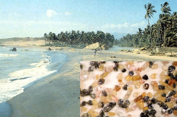
Palakkad and Kollam districts of Kerala have the worlds largest monazite deposits (as shown in the image given above − larger view in insat image).
Atomic Energy Commission was established in 1948 and the Atomic Energy Institute at Trombay was founded in 1954.
However, the Atomic Energy Institute at Trombay was renamed as Bhabha Atomic Research Centre in 1967.
The important nuclear power projects are located at Tarapur (Maharashtra); Rawatbhata near Kota (Rajasthan); Kalpakkam (Tamil Nadu); Narora (Uttar Pradesh); Kaiga (Karnataka); and Kakarapara (Gujarat).
Solar Energy
Solar energy is 7% more effective than coal or oil based plants and 10% more effective than nuclear plants.
The western part of India has greater potential for the development of solar energy.
Other Sources of Energy
The Ministry of Non-conventional Sources of Energy is responsible for the development of wind energy in India as the major source of renewable energy.
Ocean currents are the store-house of infinite energy. Hence, India has great potential for the development of tidal energy.
Natural hot springs and geysers are being used since medieval period, but in the present world, these could be potential sources of renewable energy.
Manikaran, a hot spring in Himachal Pradesh is a major renewable source of energy in India.
Bio-energy is the energy derived usually from the biological products, such as agricultural residues and other bio-waste.
Bio-energy can be converted into electrical energy, heat energy, and gas for cooking.
Okhla in Delhi presents a good example by producing bio energy from municipal waste.
Geography India - Industry
Introduction
On the basis of size, capital investment, and labor force employed, industries are classified as large, medium, small scale, and cottage industries.
On the basis of ownership, industries come under public sector, private sector, joint, and cooperative sector.
Industries of strategic and national importance are usually in the public sector.
Industries are also classified on the basis of the use of their products such as basic goods industries, capital goods industries, intermediate goods industries, and consumer goods industries.
On the basis of raw materials used by the industries − industries are categorized as agriculture-based industries, forest-based industries, mineral-based industries, and industrially processed raw material-based industries.
Location of industries is influenced by several factors like access to raw materials, power, market, capital, transport, and labor, etc.
Establishment of iron and steel industry in Bhilai (Chhattisgarh) and Rourkela (Odisha) were based on decision to develop backward tribal areas of the country.
Iron and Steel Industry
The major raw materials for the iron and steel industries are iron ore, coking coal, limestone, dolomite, manganese, and fire clay.
Major iron and steel industries in India are −
The Tata Iron and Steel plant (TISCO);
The Indian Iron and Steel Company (IISCO);
Visvesvaraiya Iron and Steel Works Ltd. (VISL);
Rourkela Steel Plant;
Bhilai Steel Plant;
Durgapur Steel Plant; and
Bokaro Steel Plant.
Some other major iron and steel industries are −
Vizag Steel Plant, in Vishakhapatnam in Andhra Pradesh is the first port based plant which started operating in 1992.
The Vijaynagar Steel Plant at Hosapete in Karnataka was developed by using indigenous technology.
The Salem Steel Plant in Tamil Nadu was commissioned in 1982.
The Rourkela Steel plant was set up in the year 1959 in the Sundargarh district of Odisha in collaboration with Germany.
The Bhilai Steel Plant was established in 1959 with Russian collaboration in Durg District of Chhattisgarh.
Durgapur Steel Plant was established in 1962 in West Bengal, in collaboration with the government of the United Kingdom
Bokaro steel plant was set up in 1964 at Bokaro with Russian collaboration.
Cotton Industry
India was famous worldwide for the production of muslin, a very fine variety of cotton cloth, calicos, chintz, and other different varieties of fine cotton cloth.
In 1854, the first modern cotton mill was established in Mumbai.
At present, the major centers of the cotton textile industry are Ahmedabad, Bhiwandi, Solapur, Kolhapur, Nagpur, Indore, and Ujjain.
Tamil Nadu has the largest number of mills; however, most of them produce yarn rather than cloth.
Davangere, Hubballi, Ballari, Mysuru, and Bengaluru are important cotton growing regions in Karnataka.
Sugar Industry
With more than one-third of the total production, Maharashtra has emerged as a leading sugar producer in the country.
Uttar Pradesh is the second largest producer of sugar.
Petrochemical Industry
Many items are derived from crude petroleum, which provide raw materials for many new industries; hence, these are collectively known as petrochemical industries.
Petrochemical industries are categorized as polymers, synthetic fibers, elastomers, and surfactant intermediate industries.
Mumbai is the hub of petrochemical industries.
Three organizations, which are working in the petrochemical sector under the administrative control of the Department of Chemicals and Petrochemicals are −
The Indian Petrochemical Corporation Limited (IPCL);
The Petrofils Cooperative Limited (PCL);
The Central Institute of Plastic Engineering and Technology (CIPET).
The National Organic Chemicals Industries Limited (NOCIL), established as private sector in 1961.
Information Technology
The Information Technology (IT) revolution opened up new possibilities of economic and social transformation.
The IT software and services industry account for almost 2% of Indias GDP.
Industrial Policy
The new Industrial Policy was implemented in 1991.
The new industrial policy has three main dimensions − liberalization, privatization, and globalization.
Within this new industrial policy, measures initiated are − abolition of industrial licensing; free entry to foreign technology; foreign investment policy; access to capital market; open trade; abolition of phased manufacturing program; and liberalized industrial location program.
Globalization means integrating the economy of the country with the world economy.
Industrial Regions
India has eight major industrial regions namely (as shown on the map given below) −
Mumbai-Pune Region,
Hugli Region,
Bengaluru-Tamil Nadu Region,
Gujarat Region,
Chhotanagpur Region,
Vishakhapatnam-Guntur Region,
Gurgaon-Delhi-Meerut Region, and
Kollam-Thiruvananthapuram Region.
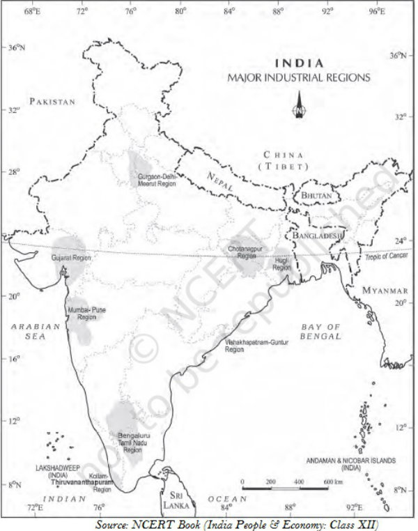
Geography India - Transport
Introduction
People use various methods to move goods, commodities, ideas from one place to another.
Land, water, and air are the major modes of transportation.
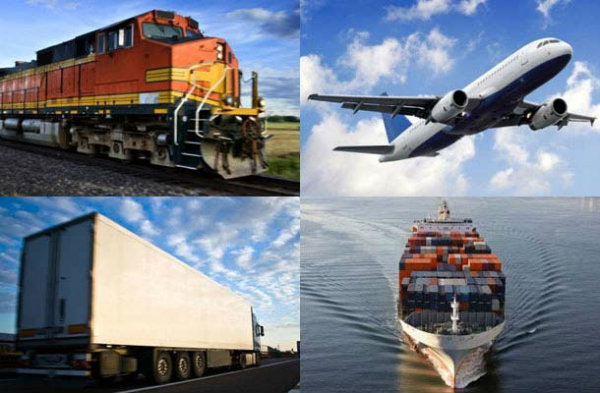
- Land transportation includes road, rail, and pipeline.
Road
With a total length of about 42.3 lakh km, India has one of the largest road networks in the world.
About 85% of passenger and 70% of freight traffic are carried by roads.
Sher Shah Suri built the Shahi (Royal) road to strengthen and consolidate his empire from the Indus Valley to the Sonar Valley in Bengal.
This road was later renamed as the Grand Trunk (GT) Road during the British period, connecting Calcutta and Peshawar.
At present, GT Road extends from Amritsar to Kolkata. It is bifurcated into 2 segments − (a) National Highway (NH)-1 from Delhi to Amritsar, and (b) NH- 2 from Delhi to Kolkata.
Roads have been classified as National Highways (NH), State Highways (SH), Major District Roads, and Rural Roads.
The National Highways Authority of India (NHAI), which is an autonomous body under the Ministry of Surface Transport was operationalized in 1995.
The main roads connecting two or more states are constructed and maintained by the Central Government. These roads are known as the National Highways.
The NHAI is responsible for the development, maintenance, and operation of National Highways.
The National Highways constitute only 1.67 per cent of the total road length, but carry about 40 per cent of the road traffic.
Golden Quadrilateral is 5,846 km long 4/6 lane, high density traffic corridor that connects Indias four big metro cities : Delhi-Mumbai-Chennai-Kolkata.
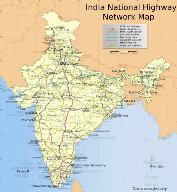
With 4,076 km long road, North-South Corridor aims at connecting Srinagar in Jammu and Kashmir with Kanyakumari in Tamil Nadu.
With 3,640 km of road length, the East-West Corridor has been planned to connect Silchar in Assam with the port town of Porbandar in Gujarat.
State Highways are constructed and maintained by the state governments.
The State Highways join the state capitals with district headquarters and other important towns.
All State Highways collectively constitute about 4 per cent of the total road length in the country.
District roads are the roads connecting the District Headquarters and the other important nodes in the district.
District roads account about 60.83 per cent of the total road length of the country.
Further, about 80 per cent of the total road length in India come under rural roads.
Other roads include Border Roads and International Highways.
The Border Road Organization (BRO) was established in May 1960 for the acceleration of economic development and strengthening defense preparedness through rapid and coordinated improvement of strategically important roads along the northern and north-eastern boundary of the country.
BRO has constructed roads in high altitude mountainous terrain joining Chandigarh with Manali (Himachal Pradesh) and Leh (Ladakh), which runs at an average altitude of 4,270 meters above the mean sea level.
The road density is only 12.14 km in Jammu and Kashmir, whereas in Kerala it is 517.77 km.
Railways
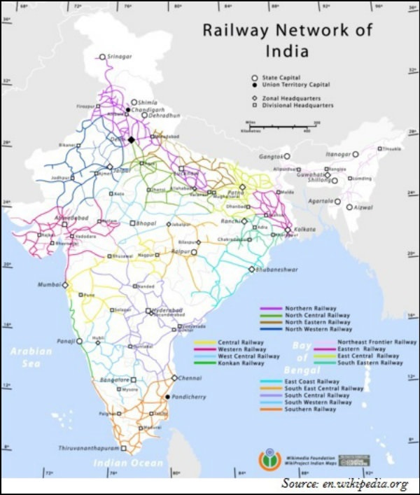
Railways was introduced to India in 1853, when a line was constructed from Bombay to Thane covering a distance of 34 km.
The total length of Indian Railways network is 64460 km. (March 2011).
Indian Railways system has been divided into sixteen zones (as shown in the map given below − the lines shown in different colors illustrate the regions of respective zones).
India has three system of railways − broad gauge (the distance between rails is 1.676 meter); meter gauge (the distance between rails is one meter); and narrow gauge (the distance between the rails is 0.762 meter or 0.610 meter).
Konkan Railway constructed along the western coast in 1998, is a landmark achievement of Indian Railway.
Konkan Railway is 760 km long rail route connecting Roha in Maharashtra to Mangalore in Karnataka.
Konkan Railway crosses 146 rivers, streams, nearly 2000 bridges, and 91 tunnels.
Asias largest tunnel which is about 6.5 km long, is constructed on the Konkan railway route near Ratnagiri in Maharashtra.
Waterways
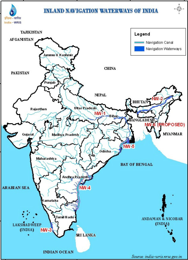
Water transport can be divided into two major categories − inland waterways and oceanic waterways.
India has 14,500 km of navigable waterways, contributing about 1% to the countrys transportation.
Currently, 5,685 km of major rivers is navigable by mechanized flat bottom vessels.
Inland Waterways Authority was set up in 1986 for the development, maintenance, and regulation of national waterways in the country.
Major National Waterways (NW) of India are NW 1 (Allahabad-Haldia covers 1,620 km); NW 2 (Sadiya-Dhubri covers 891 km); and NW 3 (KottapuramKollam covers 205 km).
Besides, NW 4 covers specified stretches of rivers Godavari and Krishna along with Kakinada Puducherry; the total distance is 1078 km.
NW 5 covers specified stretches of river Brahmani along with Matai river, delta channels of Mahanadi and Brahmani rivers and East Coast canals; the total distance is 588 km.
With 12 major and 185 minor ports, India has a vast coastline of approximate 7,517 km, including islands.
Roughly 95% of Indias foreign trade by volume and 70% by value moves through ocean routes.
Airways
Air transport in India marked its beginning in 1911 with the commencement of airmail over a little distance of 10 km between Allahabad and Naini.
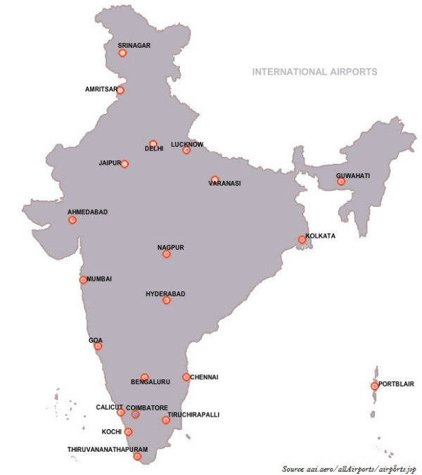
The Airport Authority of India is accountable for providing safe, efficient air traffic, and aeronautical communication services in the Indian Air Space.
Pawan Hans is the helicopter service operating in hilly areas and is widely used by tourists in north-eastern regions.
Pipelin
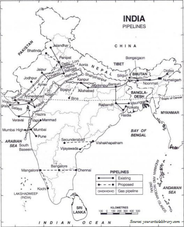
Asias first cross country pipeline covering a distance of 1,157 km was constructed by Oil India Limited (OIL) from Naharkatiya oilfield in Assam to Barauni refinery in Bihar, which further extended up to Kanpur in 1966.
Mumbai High-Koyali and Hazira-Vijaipur-Jagdishpur (HVJ) are the most important pipelines in India.
1256 km long pipeline between Salaya (Gujarat) and Mathura (U.P.) has been constructed recently.
Geography India - Communications
Radio
Radio broadcasting was started in India in 1923 by the Radio Club of Bombay.
Government took control over radio broadcasting in 1930 and established the Indian Broadcasting System.
All India Radio was constituted in 1936 and it came to be known as Akashwani from 1957.
Over a period of time, All India Radio started broadcasting a variety of programs related to information, education, and entertainment.
Among all programs, news bulletins were also broadcasted at specific occasions like the session of parliament and state legislatures.
Television
Television first went on air in 1959.
Television broadcasting has emerged as an effective audio-visual medium for disseminating information as well as educating masses.
By 1972, many Television broadcasting centers became operational throughout the country.
In 1976, TV was separated from All India Radio (AIR) and got a separate identity as Doordarshan (DD).
Indian Satellites
With the advent of satellites, the Indian Communication System has revolutionized the mode of communication.
After INSAT-IA (National Television-DD1) became operational, Common National Programs (CNP) were started for the entire network. Services were also extended to the backward and rural areas of the country.
On the basis of configuration and purposes, satellite system in India can be grouped as −
Indian National Satellite System (INSAT) and
Indian Remote Sensing satellite system (IRS).
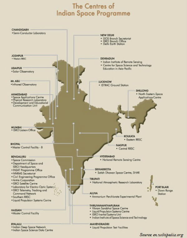
The INSAT, which was established in 1983, is a multipurpose satellite system specialized for telecommunication, meteorological observation, and for many other data and programs.
The IRS satellite system became operational only after the launch of IRS-IA in March 1988 from Vaikanour, Russia.
However, India has also developed its own Launch Vehicle PSLV (Polar Satellite Launch Vehicle).
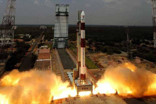
The National Remote Sensing Centre (NRSC) at Hyderabad is responsible for acquisition, processing, supply of aerial and satellite remote sensing data and continuously exploring the practical uses of remote sensing technology.
Geography India - Foreign Trade
Introduction
In 1950-51, Indias external trade was worth Rs.1, 214 crores, which rose to Rs. 22, 09,270 crores in 2009-10.
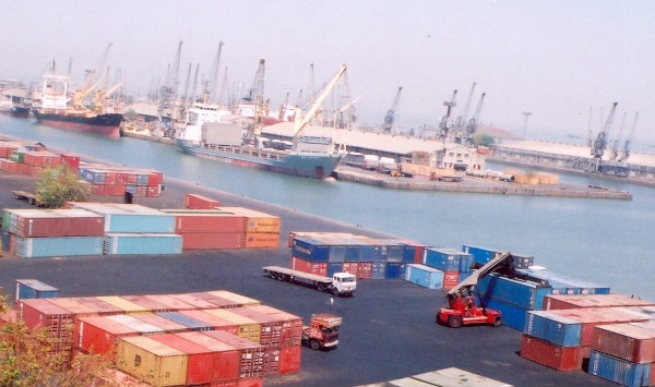
Though an increase has been registered in floricultural products, fresh fruits, marine products, and sugar, there has been a great decline in the exports of traditional items such as coffee, spices, tea, pulses, etc.
Engineering goods, gems, and jewelry contribute to a larger extent to Indias foreign trade.
With the Green Revolution in 1970s, the import of food grains declined, but it was replaced by fertilizers and petroleum.
Other major items of Indias import include pearls and semi-precious stones, gold and silver, metalliferous ores and metal scrap, non-ferrous metals, electronic goods, etc.
Trading Partners
The share of Asia and ASEAN in total trade (with India) is increased from 33.3 per cent in 2000-01 to 57.3 per cent in the first half of 2011-12, while that of Europe and America fell from 42.5 per cent to 30.8 per cent respectively.
The USA, which was in first position in 2003-04 has been relegated to third position in 2010-11.
The UAE is becoming Indias largest trading partner, followed by China (2010-11).
Sea route is the major trading route for the Indian trade.
Sea-Ports
At present, India has 12 major ports and 185 minor or intermediate ports.
The 12 major ports handled about 71 per cent of the countrys oceanic traffic in the year 2008-09.
The capacity of Indian ports increased from 20 million tons of cargo handling in 1951 to more than 586 million tons in 2008-09.
Kandla Port located in the Gulf of Kachchh, on the west coast of Gujarat has been developed as a major port.
Kandla port is specially designed to receive large quantities of petroleum and petroleum products and fertilizer.
Mumbai has a natural harbor and it is the biggest seaport of the country.
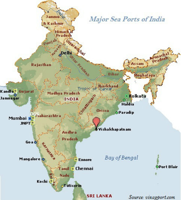
Mumbai port is situated closer to the general routes from the countries of Middle East, Mediterranean countries, North Africa, Europe, and North America where the major share of countrys overseas trade is carried out.
Jawaharlal Nehru Port at Nhava Sheva, Maharashtra was developed as a satellite port to relieve the pressure on the Mumbai port.
Jawaharlal Nehru Port is the largest container port in India.
Marmagao Port, situated at the entrance of the Zuari estuary, is a natural harbor port in Goa.
New Mangalore Port is located in the state of Karnataka; it caters to the export of iron-ore and iron-concentrates along with fertilizers, petroleum products, edible oils, coffee, tea, wood pulp, yarn, granite stone, molasses, etc.
Kochchi Port, situated at the head of Vembanad Kayal is a natural harbor port; it is popularly known as the Queen of the Arabian Sea.
Kolkata Port is a riverine port located on the Hugli River; it is 128 km inland from the Bay of Bengal.
Haldia Port is located 105 km downstream from Kolkata.
Haldia Port has been constructed to reduce the congestion at Kolkata port.
Haldia Port handles bulk cargo like iron ore, coal, petroleum, petroleum products and fertilizers, jute, jute products, cotton and cotton yarn, etc.
Paradip Port is situated on the Mahanadi delta, about 100 km from Cuttack, Odisha.
Paradip Port has the deepest harbor especially suited to handle very large vessels.
Paradip Port handles large-scale export of iron-ore.
Located in Andhra Pradesh, Visakhapatnam Port is a land-locked harbor, connected to the sea by a channel cut through solid rock and sand.
Visakhapatnam Port handles iron-ore, petroleum, and general cargo.
Chennai Port is one of the oldest ports on the eastern coast of India.
Ennore is a newly developed port in Tamil Nadu. It has been constructed 25 km north of Chennai to relieve the pressure on Chennai port.
Tuticorin Port is also an important port located in Tamil Nadu. It handles the movement of coal, salt, food grains, edible oils, sugar, chemicals, and petroleum products.
There were 19 international airports functioning in the country (February 2013); however, currently, it is 20.
Airways have the advantage of taking the least time for carriage and handling high value or perishable goods over long distances; however, it is expensive and hence not suitable for the heavy and other machinery products.
Geography India - The People
Introduction
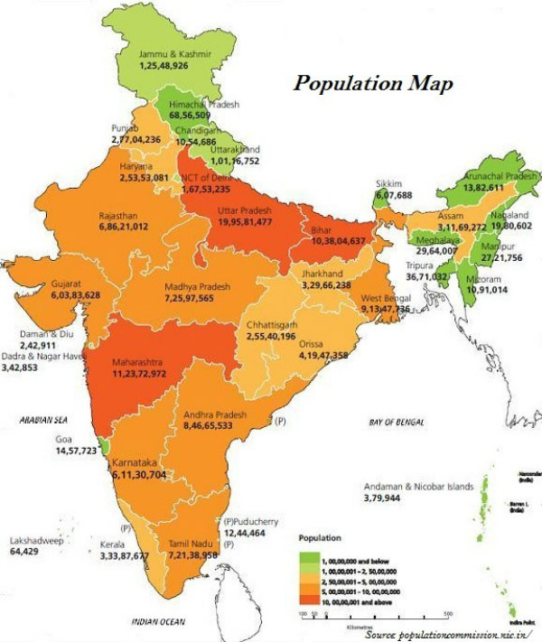
Throughout the country, India has a highly uneven pattern of the population distribution.
Uttar Pradesh has the highest population followed by Maharashtra, Bihar, and West Bengal.
Terrain, climate, and availability of water largely determine the pattern of the population distribution. However, socio-economic and historical factors also affect the pattern of population distribution.
As per the 2011 census, urban population of India was 31.16% (the details of major urban center is illustrated in the following map).
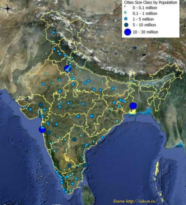
As per census 2011, the annual population growth rate is 1.64 percent.
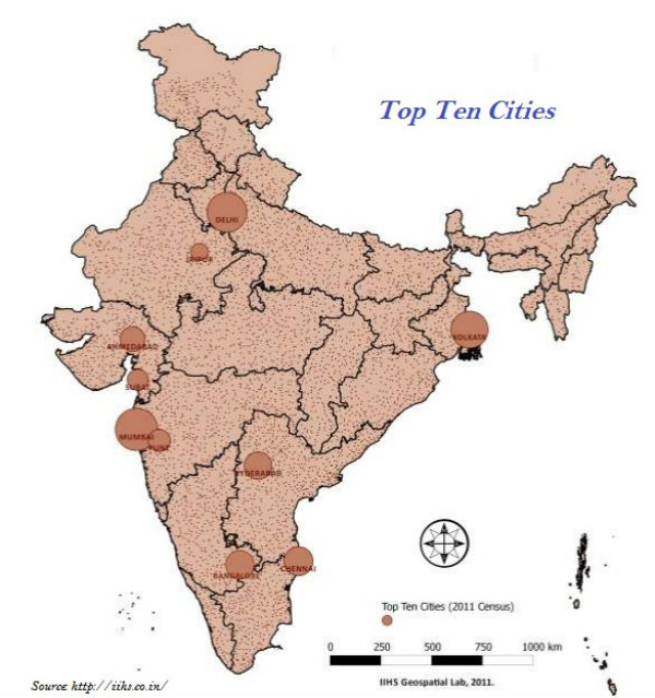
Population Density
The density of population is expressed as the number of persons per unit area.
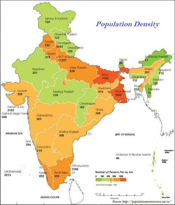
The density of population in India as per 2011 census is 382 persons per square km.
Bihar with 1102 people per square km is the most densely populated state of India followed by West Bengal (1029) and Uttar Pradesh (828).
Physiological density refers to the total population divided by the net cultivated area.
Agricultural density refers to the total agricultural population divided by the net cultivable area.
Agricultural population includes cultivators and agricultural laborers and their family members.
Phases of Population Growth
Indias population can be analyzed in four phases −
Phase I, the period between 1901 and 1921 − This period is known as stagnancy period, as the birth rate and death rate both were high and the population growth rate was very slow.
Phase II, the period between 1921 and 1951 − It was the period of steady population growth.
Phase III, the period between 1951 and 1981 − It was the period of population explosion in India.
Phase IV, from 1981 to till date − Population growth rate though still high, but reflecting a decreasing trend.
Population Composition
As per census 2011, 68.8 per cent of the total population lives in village and 31.2 per cent of the population lives in urban areas.
Considering the economic status, population can be divided into categories such as main workers, marginal workers, and non-workers.
As per the census 2011, main workers and marginal workers collectively constitute only about 39.8 percent of total population; rest are non-workers.
About 54.6 per cent of the total working population are cultivators and agricultural laborers
About 41.6 % are other workers, such as non-household industries, trade, commerce, construction, repair, and other services.
The number of female workers is relatively high in the primary sector.
The proportion of workers in agricultural sector in India has shown a declining trend over the last few decades; in 2001, it was 58.2%, whereas, in 2011, it was 54.6%.
Literacy
As per the 2011 census, literacy rate of India was 74.04% (the details of literacy rate is illustrated in the following map − state-wise).
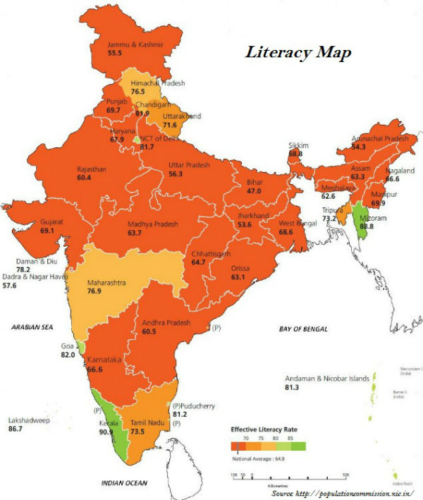
Sex Ratio
As per the 2011 census, sex ratio of India was 940 females per 1000 males (the details of sex ratio is illustrated in the following map − state-wise).
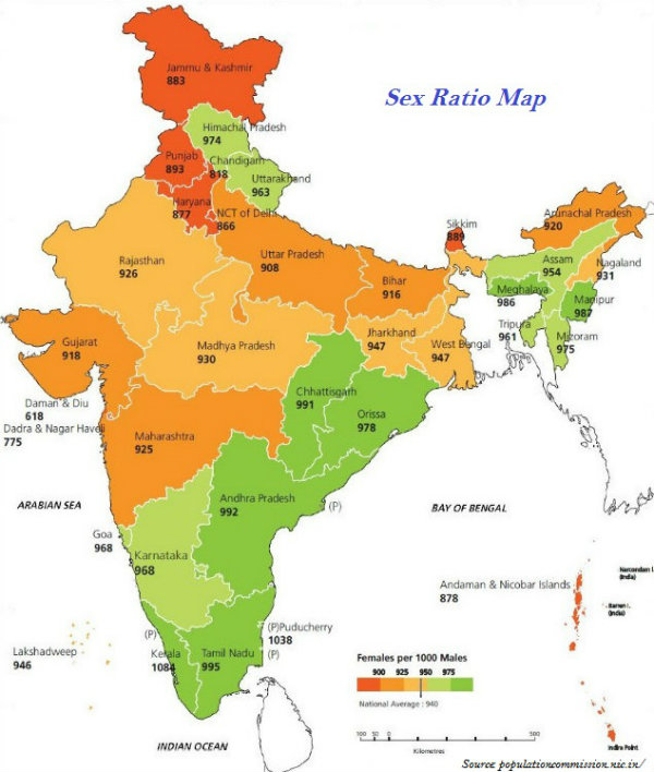
Languages
In India, there are 22 scheduled languages and hundreds of non-scheduled languages.
Among the scheduled languages, Hindi is the highest spoken language and Kashmiri and Sanskrit have the least number of speakers.
| Family | Sub-Family | Spoken Region |
|---|---|---|
Austric (Nishada) 1.38% |
Austro-Asiatic Austro-Nesian |
Meghalaya, Nicobar Islands, West Bengal, Bihar, Odisha, Assam, Madhya Pradesh, Maharashtra |
Dravidian (Dravida) 20% |
Tamil Nadu, Karnataka, Kerala, Andhra Pradesh, M.P., Odisha, Maharashtra, Bihar | |
Sino-Tibetan (Kirata), 0.85% |
TibetoMyanmari Siamese-Chinese |
Jammu & Kashmir, Himachal Pradesh, Sikkim, Arunachal Pradesh, Assam, Nagaland, Manipur, Mizoram, Tripura, Meghalaya |
IndoEuropean (Aryan) 73% |
Indo-Aryan | Jammu & Kashmir, Jammu & Kashmir, Punjab, Himachal Pradesh, U.P., Rajasthan, Haryana, M.P., Bihar, Odisha, West Bengal, Assam, Gujarat, Maharashtra, Goa. |
Religions
Religion is one of the most integral parts of the population composition of India.
More than 80 percent of the population comprises of Hindus followed by Muslims, Christians, Sikhs, Buddhists, and Jains.
Geography India - Settlement
Introduction
A cluster of dwellings of any type and size where human beings live is known as human settlement.
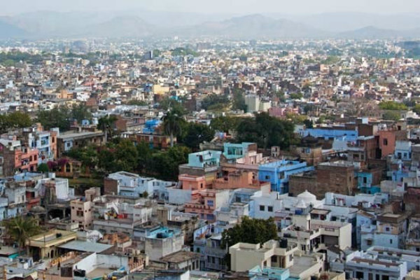
On the basis of size and type, patterns of human settlement are studied; hence, a settlement could be very small (e.g. hamlet) and could be very large (e.g. metropolitan city).
The sparsely populated settlement whose main occupation is agricultural and other primary sector activities, is known as village.
Large and densely populated settlement whose main occupational specialization is in tertiary activities is known as urban settlement.
Patterns of Settlement
The pattern of human settlement is practically influenced by −
Physical features (e.g. relief feature, climate, and availability of water);
Cultural and ethnic factors (e.g. social structure, caste, and religion);
Security factors (e.g. defence against thefts, robberies, etc.).
Categories of Settlement
Based on above discussed factors, human settlement is categorized as −
Clustered,
Agglomerated or nucleated,
Semi-clustered or fragmented,
Hamleted, and
Dispersed or isolated.
The settlement in which the houses are closely built up and compact is known as clustered settlement. The shape of clustered settlement normally varies from rectangular, radial, to linear.
Clustered settlement in India normally found in fertile alluvial plains and in the northeastern states.
The settlement, clustering in a restricted area of dispersed settlement normally looks like semi-clustered. Examples of such settlement can be seen in Gujarat plain and some parts of Rajasthan.
Some settlement is fragmented into several units and physically separated from each other is known as hamleted settlement. Examples of hamleted settlement can be seen in the middle and lower Ganga plain, Chhattisgarh and lower valleys of the Himalayas.
The isolated settlement is known as dispersed settlement. Examples of such settlement can be seen in parts of Meghalaya, Uttaranchal, Himachal Pradesh and Kerala have this type of settlement.
Types of Urban Settlement
Like rural settlement, urban settlements have also been developed during the ancient period itself.
Based on Time, Location, and Function, Urban Settlement is categorized as −
Ancient City
Medieval City
Modern City
Administrative City/Town
Industrial City
Transport City
Commercial City
Mining City
Cantonment City
Educational City
Religious City
Tourists City
Varanasi, Prayag (Allahabad), Pataliputra (Patna), Madurai, etc. are the examples of ancient city.
Delhi, Hyderabad, Jaipur, Lucknow, Agra, Nagpur, etc. are the examples of medieval city.
Surat, Daman, Panaji, Pondicherry, etc. are the examples of modern city.
Chandigarh, Bhubaneswar, Gandhinagar, Dispur, etc. are the cities developed after the independence of India.
Ghaziabad, Rohtak, Gurgaon, etc. are the satellite towns that have been developed around Delhi.
The town or cities performing administrative works are categorized as administrative towns/cities. For example, the national capital (New Delhi) and the capital of all states and Union Territories are the administrative towns/cities.
The towns/cities that developed because of the industrial development are known as industrial towns/cities. For example, Mumbai, Salem, Coimbatore, Modinagar, Jamshedpur, Hugli, Bhilai, etc.
The towns/cities primarily engaged in export and import activities are known as transport towns/cities. For example, Kandla, Kochchi, Kozhikode, Vishakhapatnam, etc.
The towns/cities primarily engaged in trade and business are known as commercial towns. For example, Kolkata, Saharanpur, Satna, etc.
The towns that developed because of the mining activities are known as mining towns. For example, Raniganj, Jharia, Digboi, Ankaleshwar, Singrauli, etc.
The towns that developed as garrison towns are known as Garrison Cantonment towns. For example, Ambala, Jalandhar, Mhow, Babina, Udhampur, etc.
The towns that developed because of the development of educational institutions are known as educational towns. For example, Roorkee, Varanasi, Aligarh, Pilani, Allahabad etc.
Some towns mark their development with the existence of religious shrines. Such towns are known as religious towns. For example, Varanasi, Mathura, Amritsar, Madurai, Puri, Ajmer, Pushkar, Tirupati, Kurukshetra, Haridwar, Ujjain, etc.
The towns that developed because of the influx of tourists are known as tourists towns. For example, Nainital, Mussoorie, Shimla, Pachmarhi, Jodhpur, Jaisalmer, Udagamandalam (Ooty), Mount Abu, etc.
Modern Indian Cities
Based on the population size, the census of India classifies urban centers into six classes (see the table given below).
| S.No. | Classes & Population |
|---|---|
| 1 | Class I 100,000 and above |
| 2 | Class II 50,000 to 99,999 |
| 3 | Class III 20,000 to 49,999 |
| 4 | Class IV 10,000 to 19,999 |
| 5 | Class V 5,000 to 9,999 |
| 6 | Class VI less than 5000 |
The cities with population beyond five million are known as mega cities.
Urban agglomeration forms in a situation when a town and its adjoining urban areas outgrowth, or two or more contiguous towns with or without their outgrowth, or a city and one or more adjoining towns with their outgrowth together forming a contiguous spread.
More than 60 per cent of urban population in India lives in Class I towns.
Out of total 423 cities, 35 cities/urban agglomerations are metropolitan cities and six of them are mega cities.
Geography India - Migration
Introduction
During colonial period (i.e. British period) millions of the indentured laborers were sent to Mauritius, Caribbean islands (Trinidad & Tobago and Guyana), Fiji, and South Africa by British Government largely from the states of Uttar Pradesh and Bihar.
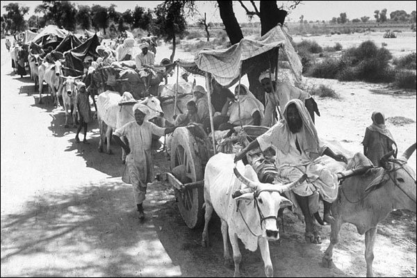
All such migrations were covered under time-bound contracts known as Girmit Act (Indian Emigration Act).
The recent wave of migrants consists of professionals including software engineers, doctors, engineers, management consultants, financial experts, and media persons to countries like USA, Canada, UK, Australia, New Zealand, Germany, etc.
Migration Facts
The first major modification was done in 1961 Census, as two additional components i.e. place of birth (village or town) and duration of residence (if born elsewhere) were added.
Further, in 1971, another component added i.e. on place of last residence and duration of stay at the place of enumeration.
In 1981, Information on reasons for migration were incorporated.
According to 2001 census, out of total 1,029 million population, 307 million (30 per cent) were reported as migrants in terms of place of birth.
Under the intra-state migration, numbers of female migrants are more than male (marriage related migration).
As per the census 2001, India has recorded that more than 5 million persons have migrated to India from other countries; largely, from the neighboring countries including Bangladesh, Nepal, and Pakistan.
As per the census 2001, there are about 20 million people of Indian Diaspora, spread across the 110 countries of the world.
In terms of in-migration, Maharashtra occupied the first place (2.3 million net in-migrants), followed by Delhi, Gujarat, and Haryana.
On the other hand, in terms of out-migration, Uttar Pradesh (-2.6 million) and Bihar (-1.7 million) were the top states.
In terms of the urban agglomeration (UA), Greater Mumbai had received the maximum number of in-migrants.
Causes of Migration
Causes of migration are categorized as push factor and pull factor.
Push factors force people to migrate; for example, unemployment, lack of infrastructure (such as hospital, education institutions, etc.), natural disasters (such as flood, drought, earthquake, cyclone, etc.), local conflicts, war, etc.
Pull factors attract people from different places; for example, better opportunities for education and employment; better health facilities; and various sources of entertainment, etc.
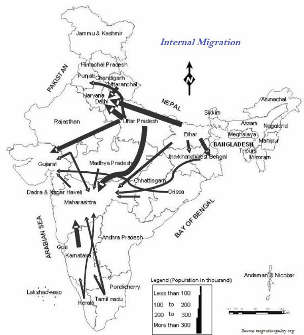
Normally, the reason behind female migration throughout India is largely marriage related; however, Meghalaya has a reverse scenario.
Remittances from the international migrants are one of the major sources of foreign exchange.
For thousands of the poor villages of states like Bihar, Uttar Pradesh, Odisha, Andhra Pradesh, Himachal Pradesh, etc. remittance acts as life blood for their subsistence.
Impacts of Migration
Development of slums in industrially developed states, such as Maharashtra, Gujarat, Karnataka, Tamil Nadu, and metropolitan areas, such as Delhi, Mumbai, Kolkata, etc. is a negative consequence of unregulated migration within the country.
One of the major negative impacts of migration is imbalances in age and sex composition at both the places − sending region (out-migration) and receiving region (in-migration).
Migration intermixes people of diverse cultural backgrounds
Because of unbalanced migration, the receiving regions (especially urban areas) are facing many environmental problems, such as pollution, depletion of ground water, solid waste management problems, etc.
Geography India - Regional Development
Introduction
India has centralized planning and the task of planning in India has been entrusted to the Planning Commission of India.
Planning Commission of India is a statutory body headed by the Prime Minister and has a Deputy Chairman and other members.
However, the Planning Commission of India is recently is now National Institution for Transforming India or simply NITI Aayog.
The planning in the country is largely carried out through the array of Five Year Plans.
At present, the Twelfth Five Year Plan is running, which was initiated in 2012 with a focus on Faster, More Inclusive and Sustainable Growth.
Approaches of Planning
Normally, there are two approaches of planning. They are −
Sectoral planning
Regional planning.
Sectoral Planning
Sectoral planning means formulation and implementation of the sets of schemes or programs aimed at development of various sectors of the economy such as agriculture, irrigation, manufacturing, power, construction, transport, communication, social infrastructure, and services.
Regional Planning
Since all the regions of India have not developed on the same lines, therefore, to reduce the regional imbalances, regional planning was introduced.
Target Area Planning
In order to reduce the regional and social disparities, the Planning Commission introduced the target area and target group approaches to planning.
Some of the examples of target area planning directed towards the development of target areas are −
Command Area Development Program;
Drought Prone Area Development Program;
Desert Development Program; and
Hill Area Development Program.
The examples of target area planning are − the Small Farmers Development Agency (SFDA) and Marginal Farmers Development Agency (MFDA).
Hill Area Development Programs were initiated during the Fifth Five Year Plan. The plan covers 15 districts comprising all the hilly districts of Uttarakhand, Mikir Hill and North Cachar hills of Assam, Darjeeling district of West Bengal and Nilgiri district of Tamil Nadu.
Major aims of Hill Area Development Program were harnessing the indigenous resources of the hilly areas through the development of horticulture, plantation agriculture, animal husbandry, poultry, forestry, and small-scale and village industry.
Drought Prone Area Program was initiated during the Fourth Five-Year Plan with the objectives of providing employment to the people in droughtprone areas and creating productive assets.
The drought prone area in India largely covers semi-arid and arid tract of Rajasthan; Gujarat; Western Madhya Pradesh; Marathwada region of Maharashtra; Rayalseema and Telangana plateaus of Andhra Pradesh & Telangana; Karnataka plateau; and highlands and interior parts of Tamil Nadu.
Planning Facts
In 1967, the Planning Commission of India identified 67 districts (entire or partly) of the country prone to drought.
In 1972, the Irrigation Commission introduced the criterion of 30% irrigated area and demarcated the drought prone areas.
In 1970s, the phrases such as redistribution with growth and growth and equity were incorporated in the definition of development.
Over period of time, the meaning of Development did not remain restricted to economic growth rather it also includes the issues such as improving the wellbeing and living standard of the people; availing the health facilities; education; equality of opportunity; and ensuring political and civil rights.
The concept of sustainable development emerged in the wake of general rise in the awareness of environmental issues in the late 1960s in the Western World.
The publication of The Population Bomb by Ehrlich in 1968 and The Limits to Growth by Meadows at al in 1972 further raised the environmental concerns.
The United Nations established a World Commission on Environment and Development (WCED) headed by the Norwegian Prime Minister Gro Harlem Brundtland. This is the reason that its report submitted in 1987 with the name Our Common Future, is also known as Brundtland Report.
In this report, sustainable development is defined as − development that meets the needs of the present without compromising the ability of future generations to meet their own needs.
Likewise, Sustainable development takes care of ecological, social, and economic aspects of the development during the present times and pleads for conservation of resources to enable the future generations to use these resources.
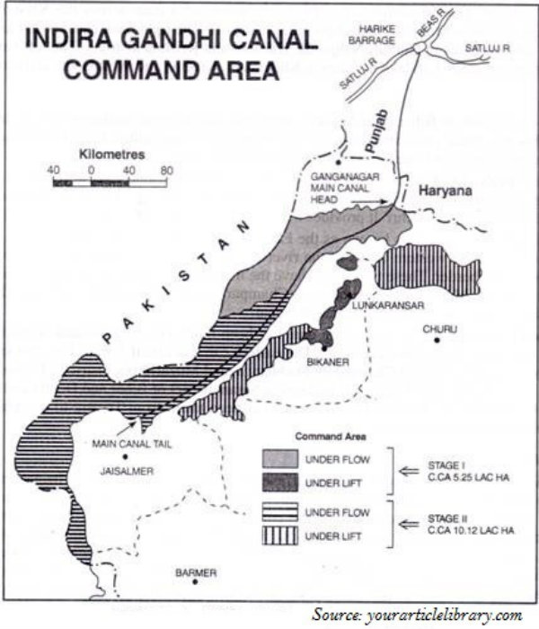
Indira Gandhi Canal, which previously was popular as the Rajasthan Canal, is one of the largest canal systems in India.
The idea of Indira Gandhi Canal was proposed by Kanwar Sain in 1948; however, the canal project was launched on 31 March, 1958.
The canal originates at Harike barrage in Punjab and runs parallel to Pakistan border and covers an average distance of 40 km in Thar Desert of Rajasthan.
Geography India - Disasters
Introduction
Disaster is an undesirable catastrophe resulting from the forces that are largely beyond human control, strikes quickly with little or no warning, and causes or threatens serious disruption of life and property. For example, earthquake, tsunami, cyclone, flood, etc.
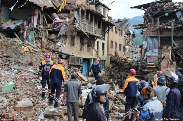
Disasters are normally caused by nature (beyond human control); however, there are many human-induced disasters. For example, Bhopal Gas tragedy, Chernobyl nuclear disaster, wars, release of CFCs (Chlorofluorocarbons), releasing greenhouse gases, etc.
Besides, some disasters are natural in occurence, but those are indirectly caused by human activities. For example, landslides in hilly regions, droughts, and floods due to deforestation and other environmental damage.
On the other hand, Natural Hazards are the elements of circumstances in the Natural environment that have the potential to harm people or property or both.
The disasters are global in nature; hence, to combat with it, the United Nations made a systematic strategy at the World Conference on Disaster Management held in May 1994 at Yokohama, Japan.
The Yokohama conference however, is popular as the Yokohama Strategy and Plan of Action for a Safer World.
Categories of Natural Disaster
Natural Disasters are broadly categorized as −
Atmospheric Disasters
Terrestrial Disasters
Aquatic Disasters
Biological Disasters
Atmospheric disasters include blizzard, thunderstorm, lightning, tropical cyclone, tornado, drought, hailstorm, frost, heat wave, cold waves, etc.
Terrestrial disasters include earthquake, volcanic eruption, landslide, avalanches, subsidence, etc.
Aquatic disasters include flood, tidal waves, storm surge, tsunami, etc.
Biological disasters include fungal, bacterial, and viral diseases (e.g. bird flu, dengue, etc.).
Disasters Zone
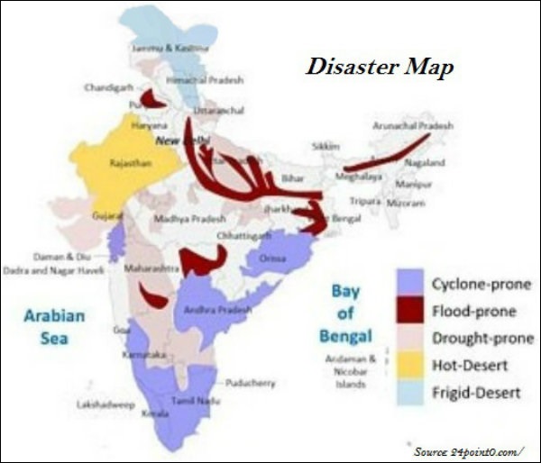
Very High Damage Earthquake Risk Zone in India include the north-eastern regions, areas to the north of Darbhanga and Araria along the Indo-Nepal border in Bihar, Uttarakhand, Western Himachal Pradesh (around Dharamshala) and Kashmir Valley in the Himalayan region, and the Kachchh (Gujarat).
High Damage Earthquake Risk Zone in India are parts of Jammu and Kashmir, Himachal Pradesh, Northern parts of Punjab, Eastern parts of Haryana, Delhi, Western Uttar Pradesh, and Northern Bihar.
Earthquakes and volcanic eruptions normally cause the sea-floor to move abruptly resulting in sudden displacement of ocean water in the form of high vertical waves, which are known as tsunamis (shown in the image given below).

Tsunamis can be observed frequently along the Pacific ring of fire, particularly along the coast of Alaska, Japan, Philippines, and other islands of Southeast Asia, Indonesia, Malaysia, Myanmar, Sri Lanka, and India etc.
Tropical cyclones are intense low-pressure areas, confined between $30^{\circ}N$ and $30^{\circ}S$ latitudes.
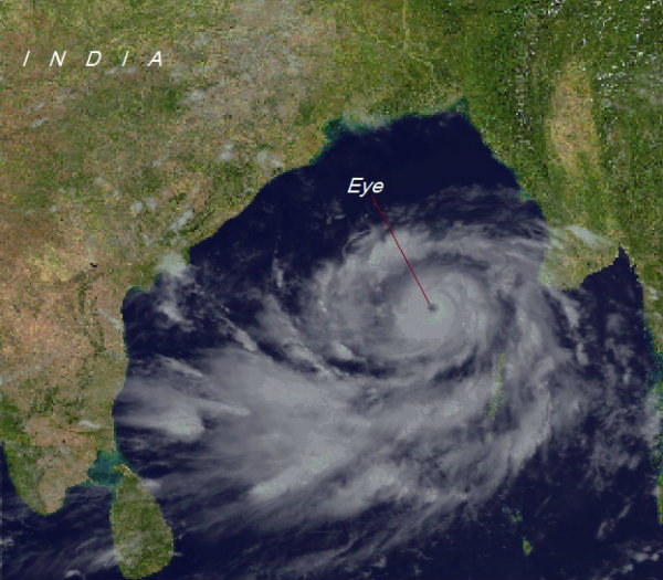
The center of the cyclone is mostly a warm and low-pressure, cloudless core known as eye of the storm (as shown in the image below) −
The ideal location of the tropical cyclone in India is Bay of Bengal.
Cyclones in the Bay of Bengal normally develop in the months of October and November.
Rashtriya Barh Ayog (National Flood Commission) identified 40 million hectares of land as flood-prone in India.
Assam, West Bengal, and Bihar are the high flood-prone states of India.
About 30 per cent of Indias total area comes under drought prone area, which affects about 50 million people.
The western part of Rajasthan is categorized as Extreme Drought Affected Areas.
Parts of eastern Rajasthan; many parts of Madhya Pradesh; eastern parts of Maharashtra; interior parts of Andhra Pradesh and Karnataka Plateau; northern parts of interior Tamil Nadu; southern parts of Jharkhand; and interior parts of Odisha are categorized as Severe Drought Prone Area.
Young mountainous areas of North and north-eastern India (the Himalayan regions), Andaman and Nicobar; high rainfall regions with steep slopes in the Western Ghats and Nilgiris; along with areas of frequent earthquakes, etc. are categorized as Very High Landslide Vulnerability Zone.
Disaster Management
The Disaster Management Bill, 2005, defines disaster as a catastrophe, mishap, calamity or grave occurrence affecting any area, arising from natural or man-made causes, or by accident or negligence which results in substantial loss of life or human suffering or damage to, and destruction of, environment, and is of such nature or magnitude as to be beyond the coping capacity of the community of the affected area.
A situation when there is a prolonged period of inadequate rainfall is known as Meteorological Drought.
When soil moisture that is necessary to support the crops, is low or insufficient to support crop cultivation, it is known as Agricultural Drought.
When the productivity of a natural ecosystem fails because of the shortage of water and as a consequence of ecological distress, damages occur in the ecosystem, it is known as Ecological Drought.
Geography World - Introduction
The term geography was first coined by a Greek scholar Eratosthenes.
The word geography carries basically two Greek terms i.e. geo (meaning earth) and graphos (meaning description), and the meaning of geography is description of the earth.
Geography is an interdisciplinary subject as well as it is a discipline of spatial synthesis.
Richard Hartshorne defines Geography as Geography is concerned with the description and explanation of the areal differentiation of the earths surface.
Hettner defines Geography as Geography studies the differences of phenomena usually related in different parts of the earths surface.
Further, the following diagram summarizes the concept of Geography as −
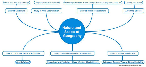
Approaches to Study Geography
The major approaches to study geography are −
- Systematic Approach and
- Regional Approach.
The systematic approach was introduced by a German geographer Alexander Von Humboldt.
On the other hand, the regional approach was also developed by a German geographer namely Karl Ritter; he was a contemporary of Humboldt.
In the systematic approach, first a phenomenon is studied world over as a whole, and then the identification of typologies or spatial patterns is done.
On the other hand, in the regional approach, first the world is divided into regions at different hierarchical levels and then all the geographical phenomena in a particular region are studied.
Because of the different approaches, geography is better known for its dualistic characteristics.
Branches of Geography
Based on systematic approach, main branches of geography are −
Physical Geography
Human Geography
However, Biogeography is the third branch, which is an interface between physical geography and human geography.
Major branches of Physical Geography are − Geomorphology, Climatology, Hydrology, and Soil Geography.
Major branches of Human Geography are − Social/Cultural Geography; Population and Settlement Geography; Historical Geography; Political Geography; and Economic Geography.
Major branches of Biogeography are − Plant Geography, Zoo Geography, Ecology/ecosystem, and Environmental Geography.
Based on Regional Approach, major branches of Geography are −
- Regional Studies,
- Regional Planning,
- Regional Development, and
- Regional Analysis.
Besides, there are some branches that study both the approaches. The branches are Geographical Thought, (Philosophy) and Methods and Techniques.
Methods and Techniques include Cartography, Quantitative Techniques/Statistical Techniques, Geo-informatics comprising techniques such as Remote Sensing, GIS, GPS, etc.
Evolution of the Earth
Introduction
There are dozens of hypotheses proposed regarding the origin of the earth by different philosophers.
However, one of the hypotheses namely Nebular Hypothesis given by Immanuel Kant and revised by Laplace became more popular.
According to Nebular Hypothesis, the planets were formed out of a cloud of material associated with a youthful sun.
Big Bang Theory, which is also known as expanding universe hypothesis is the modern and the most accepted theory.
Edwin Hubble was the first one who provided evidence that the universe is expanding, in 1920.
It is believed that the event of Big Bang took place about 13.7 billion years from now.
According to the Big Bang theory (as shown in the image given below), the universe originated from an extremely dense and hot state and keeps expanding till date.
Galaxy is a group of stars. Galaxies normally spread over vast distances, which are measured in thousands of light-years.
A galaxy starts to form by the accumulation of hydrogen gas in the form of a very large cloud called nebula.
One light year is the distance travelled by light in one year, which is equal to $9.46110^{12}km$.
Light travels at the speed of 300,000 km/second.
The mean distance between the sun and the earth is about 149,598,000 km. And, in terms of light years, it is 8.311 minutes.
Milky Way
Our Solar system namely (part of Milky Way galaxy) consists of eight planets, the sun, 63 moons, millions of smaller bodies like asteroids and comets and huge quantity of dust-particles and gases.
The planets of Milky Way were formed about 4.6 billion years ago.
The planets, Mercury, Venus, Earth, and Mars are called the inner planets as they lie between the sun and the belt of asteroids and the rest four planets i.e. Jupiter, Saturn, Uranus, and Neptune are known as outer planets.
In addition to this, the inner planets are also known as Terrestrial Planets, meaning earth-like as they are made up of rocks and metals, and have relatively high densities.
On the other hand, the outer planets are known as Jovian (Jupiter like) or Gas Giant Planets.
However, all the planets are formed in the same period i.e. about 4.6 billion years ago.
The terrestrial planets were formed in the closer to the parent star where it was too warm for gases to condense to solid particles, whereas Jovian planets were formed at quite a distant location from the parent star.
The solar wind was most intense nearer to the sun; so, it blew off lots of gas and dust from the terrestrial planets; however, the solar winds were not all that intense to cause similar removal of gases from the Jovian planets.
The moon is the only natural satellite of the planet earth.
The earth has a layered structure and hence, from the surface to deeper depths (i.e. inner core), the earth has different zones/layers and each of these contains materials of different characteristics.
The present composition of the earths atmosphere is chiefly contributed by nitrogen and oxygen, as the primordial atmosphere with hydrogen and helium, is supposed to have been stripped off as a result of the solar winds.
Degassing is the process through which the gases were outpoured from the interior of the earth.
Further, continuous volcanic eruptions contributed water vapor and gases to the atmosphere.
The earths oceans were formed within 500 million years from the evolution of the earth.
About 3,800 million years ago, life began to evolve and the process of photosynthesis got evolved about 2,500-3,000 million years ago.
Primarily, life remained confined to the oceans for a long time.
Oceans began to have the contribution of oxygen through the process of photosynthesis.
Over a period of time, oceans were saturated with oxygen; however, about 2,000 million years ago, oxygen began to flood the atmosphere.
Geography World - Climate
Koeppens Climate Classification
The most widely used classification of climate is the climate classification scheme propounded by V. Koeppen.
Koeppen identified a close relationship between the distribution of vegetation and climate.
Therefore, he selected certain values of temperature and precipitation and related them with the distribution of vegetation and used the values for classifying the world climates.
Likewise, Koeppens world climate classification is based on mean annual and mean monthly temperature and precipitation data.
Koeppen used symbolic (alphabetic) letters (i.e. use of capital and small letters) to designate climatic groups and types.
Koeppen broadly categorized five major climatic groups; four of them are based on temperature and one on precipitation.
The following table describes the division of Koeppens climate −
| Symbol | Descriptions | Characteristics |
|---|---|---|
| A | Tropic | Average temperature of the coldest month is 18 C or higher. |
| B | Dry Climates | Potential evaporation exceeds precipitation. |
| C | Warm Temperate | The average temperature of the coldest month of the (Mid-latitude) climates years is higher than minus 3C but below 18C. |
| D | Cold Snow Forest Climates | The average temperature of the coldest month is minus 3 C or below. |
| E | Cold Climates | Average temperature for all months is below 10 C. |
| H | High Land | Cold due to elevation. |
The following table describes Koeppens World Climate Classification in details −
| Group | Type | Letter Code | Characteristics |
|---|---|---|---|
| A-Tropical Humid Climate | Tropical wet | Af | No dry season |
| Tropical monsoon | Am | Monsoonal, short dry season | |
| Tropical wet & dry | Aw | Winter dry season | |
| B-Dry Climate | Subtropical steppe | BSh | Low-latitude semi-arid or dry |
| Subtropical desert | BWh | Low-latitude arid or dry | |
| Mid-latitude steppe | BSk | Mid-latitude semi-arid or dry | |
| Mid-latitude desert | BWk | Mid-latitude arid or dry | |
| C-Warm temperate (Midlatitude) Climates | Humid subtropical | Cfa | No dry season, warm summer |
| Mediterranean | Cs | Dry hot summer | |
| Marine west coast | Cfb | No dry season, warm and cool summer | |
| D-Cold SnowForest Climates | Humid continental | Df | No dry season, severe winter |
| Subarctic | Dw | Winter dry and very severe | |
| E-Cold Climates | Tundra | ET | No true summer |
| Polar ice cap | EF | Perennial ice | |
| H-Highland | Highland | H | Highland with snow cover |
The following map shows the worlds climatic regions as classified by Koeppen −
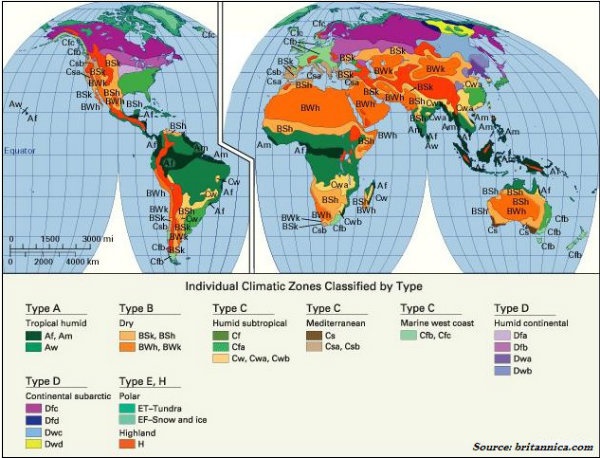
Geography World - Transport
Introduction
Trade or the exchange of commodities largely depends on transportation and communication.
Transport is a service or facility for the carriage of persons and goods from one place to the other using humans, animals, and other means of transport.
Transportation normally occurs through land, water, and air.
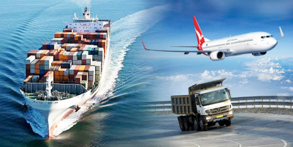
Roadways
Road transport is more preferred especially for the short distance, as it provides door-to-door service.
The worlds total motorable road length is measured about 15 million km, of which North America accounts for 33%.
The highest road density and the highest number of vehicles are registered in North America.
In North America, the highway density is about 0.65 km per sq km. So, every place is not more than 20 km distance from a highway.
Roads laid along international boundaries are called border roads.
Railways
Probably, the first public railway line was opened in 1825 between Stockton and Darlington in northern England.
Belgium has the highest density of 1 km of railway for every 6.5 sq. km area.
In Russia, railways account for about 90% of the countrys total transport with a dense network west of the Urals.
Australia has about 40,000 km of railways, of which 25% are found in New South Wales alone.
Transcontinental railways run across the continent and connect its two ends.
TransSiberian Railways is major rail route of Russia, which runs from St. Petersburg in the west to Vladivostok on the Pacific Coast in the east.
Major cities that trans-Siberian railways connects are Moscow, Ufa, Novosibirsk, Irkutsk, Chita, and Khabarovsk (as shown in the map given below).
Trans-Siberian railways is the most important route in Asia and the longest (i.e. 9,332 km) double-tracked and electrified transcontinental railway in the world.
TransCanadian Railways is 7,050 km long rail-line, running between Halifax in the east and Vancouver on the Pacific Coast in Canada.
Major cities that trans-Canadian railways connects are Montreal, Ottawa, Winnipeg, and Calgary.
The Orient Express runs from Paris to Istanbul passing through the cities Strasbourg, Munich, Vienna, Budapest, and Belgrade.
Waterways
The sea routes offer a smooth highway traversable in all directions with no maintenance costs.
The Northern Atlantic Sea Route covers one fourth of the worlds foreign trade; so, it is the busiest sea route in the world and popularly known as the Big Trunk Route.
The MediterraneanIndian Ocean Sea Route connects the highly industrialized Western European regions with West Africa, South Africa, South-east Asia, and the commercial agriculture and livestock economies of Australia and New Zealand.
The Cape of Good Hope Sea Route connects West European and West African countries with Brazil, Argentina, and Uruguay in South America.
Trade across the vast North Pacific Ocean moves by many routes, which converge at Honolulu.
The Panama and Suez Canals are two vital man-made navigation canals.
Connecting the Mediterranean Sea and the Red Sea, the Suez Canal had been constructed in 1869.
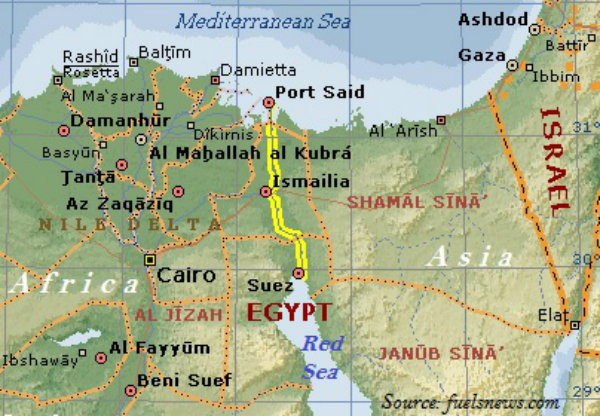
Suez Canal was constructed between Port Said in the north and Port Suez in the south in Egypt (as shown in the map given below).
Suez Canal is about 160 km long and 11 to 15 m deep.
About 100 ships travel daily through Suez Canal and each ship takes 10-12 hours to cross the canal.
Panama Canal connects the Atlantic Ocean in the east to the Pacific Ocean in the west (as shown in the image given below).
Panama Canal was constructed across the Panama Isthmus between Panama City and Colon by the U.S. government.
The reduction in distance because of the construction of Suez Canal and Panama Canal is shown in the following map −
Rhine River flows through Germany and the Netherlands.
The Rhine is navigable for 700 km from Rotterdam, at its mouth in the Netherlands to Basel in Switzerland.
The Great Lakes of North America i.e. Superior, Huron, Erie, and Ontario are connected by Soo Canal and Welland Canal to form an inland waterway.
Pipelines are normally used extensively to transport liquids and gases such as water, petroleum, and natural gas for an uninterrupted flow.
Geography World - Communications
Introduction
Communication through satellites has emerged as a new area in communication technology since the 1970s.
The first major breakthrough of the communication is the use of optic fiber cables (OFC) as it allows large quantities of data to be transmitted rapidly, securely, and are virtually error-free.
However, with the digitization of information in the 1990s, telecommunication slowly merged with the computers and constituted an integrated network termed as the Internet.
Today, Internet is the largest electronic network on the planet connecting more than 1,000 million people in more than 100 countries of the world.
Indian satellite Aryabhatt was launched on April 19, 1979, Bhaskar-I in 1979, and Rohini in 1980.
Further, on 18 June 1981, APPLE (Arian Passenger Payload Experiment) was launched through Arian rocket. Thereupon, a series of satellites have been launched for different purposes.
Cyberspace is the world of electronic computerized space. It consists of the Internet such on the World Wide Web (www).
Currently, the majority of the internet users in the world are living in U.S.A., U.K., Germany, Japan, China, and India.
Cyberspace has been expanding the contemporary economic and social space of humans through e-mail, e-commerce, e-learning and e-governance.
Likewise, these modern communication systems, more than transportation, have made the concept of global village a reality.
Geography World - Population
Introduction
Roughly, 90 per cent of the world population lives in about 10 per cent of its land area.
The 10 most populous countries of the world contribute about 60 per cent to the worlds population.
Out of the top ten most populous countries, 6 are located in Asia.
China is the most populous country of the world followed by India, the USA, Indonesia, Brazil, Pakistan, Bangladesh, Nigeria, Russian Federation, and Japan.
The ratio between the number of people to the size of land is known as the density of population.
The density of Population is usually measured in persons per sq. km.
Factors Influencing Population Distribution
Major factors that influence the distribution of population (i.e. density of population) are −
Availability of water
Landforms
Climate
Soils
Availability of mineral resources
Urbanization
Industrialization
Social & Cultural factors
Change in Population
The change in the number of inhabitants of a given territory during a specific period of time; this change may be either positive or negative.
The positive change in population is known as population growth.
Natural Population Growth is the increased population, which is calculated by deducting total numbers of deaths from the total number of births in a particular region between two points of time.
The actual growth of population is calculated as −
Births − Deaths + In Migration − Out Migration.
Births, deaths, and migration are the three components of population change.
The Crude Birth Rate (CBR) is expressed as number of live births in a year per thousand of the population.
Crude Death Rate (CDR) is expressed in terms of deaths in a particular year per thousand of population in a particular region.
Migration
When people move from one place to another, the place they move from is called the Place of Origin and the place they move to is known as the Place of Destination.
Migration may be permanent, temporary, or seasonal.
Migrants who move into a new place are known as Immigrants.
Migrants who move out of a place are known as Emigrants.
Population Growth
First time one billion population, world attains in 1830, the second billion population after 100 years (i.e. in 1930), the third billion population after 30 years (i.e. in 1960), the fourth billion population after 15 years (i.e. in1975), the fifth billion population after 12 years (i.e. in 1987), the sixth billion population after 12 years (i.e. in 1999), and the seven billion population again after 12 years (i.e. in 2011).
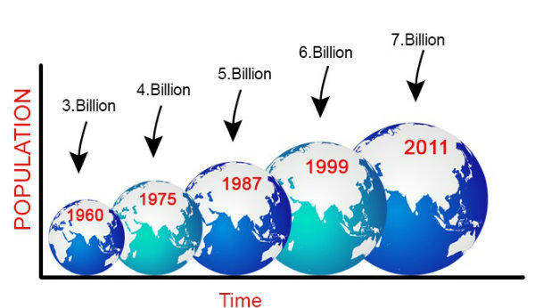
Industrial revolution along with fast technological advancement helped in the reduction of death rate and provided a stage for accelerated population growth.
Normally, developed countries take more time to increase their population than developing countries.
Many of the African countries growth rate is much higher; annual population growth rate even more than 4%.
On the other hand, many countries of the Eastern Europe including Russia, Latvia, Estonia, Germany, Portugal, Italy, etc. have negative population growth rate.
The following map shows the population density of the world population −
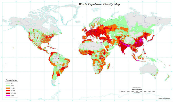
Demographic Transition Theory
Demographic transition theory describes population change of a given region; further, it explains that population changes from high births and high deaths to low births and low deaths, as the society progresses from rural, agrarian and illiterate to urban, industrial and literate society.
Demographic transition theory is explained in three stages as −
Stage I
The first stage is the period of high fertility and high mortality, so most likely no population change or very low population growth.
In the first stage, people are largely engaged in agriculture (primary sector).
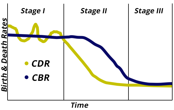
Further, in the first stage, life expectancy used to be low and people are mostly illiterate and have low levels of technology.
Stage II
In the second stage, initially, fertility remains high, but over the period of time, it starts declining. On the other hand, mortality rate gets reduced because of the improvements in sanitation and health condition; likewise, population growth rate increases.
Stage III
In the last stage, both the fertility and the mortality decline considerably; resultantly, the population is either stable or grows slowly (as shown in the graph given above).
In the last or III stage, the population becomes urbanized, literate, and has high technical knowhow and deliberately controls the family size.
In 1793, Thomas Malthus propounded a theory and stated that the number of people would increase faster than the food supply.
Population Composition
The ratio between the number of women and men in the population is known as the Sex Ratio.
The sex ratio is an important indicator about the status of women in a country.
Females have a biological advantage over males because they are more resilient than males.
The world population illustrates a sex ratio of 102 males per 100 females.
With record 85 males per 100 females, Latvia has the highest sex ratio in the world; on the other hand, in Qatar, there are 311 males per 100 females.
The sex ratio is favorable for females in (about) 139 countries of the world and unfavorable in rest of the countries.
Asia has a low sex ratio. For example, countries like China, India, Saudi Arabia, Pakistan, and Afghanistan have a lower sex ratio.
On the other hand, many parts of Europe have greater sex ratio; probably because of better status of women in society and large number of males migrating to different parts of the world (in the past).
Age structure of a country is an important indicator of population composition that represents the number of people of different age groups.
The age group of 15-59 indicates a large number of working population; the most productive age group.
On the other hand, a greater proportion of population above 60 years represents an ageing population and they require more expenditure on health care facilities.
Similarly, high proportion of young population of a country means − the country has high birth rate and the population is youthful.
The age-sex structure of a population refers to the number of females and males in different age groups.
Population Pyramid
A population pyramid is used to study the age-sex structure of the population.
The shape of the population pyramid illustrates the characteristics of the population.
The following image illustrates the different shapes of pyramid that shows different compositions −
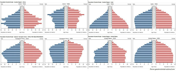
The left side illustrates the percentage of males; on the other hand, the right side shows the percentage of women in each age group.
In Western countries, males outnumber females in rural areas and females outnumber the males in urban areas. On the other hand, the countries like Nepal, Pakistan, and India have reverse case.
Geography World - Human Settlement
Introduction
Human settlements can be permanent or seasonal/temporary; rural or urban.
The process of people moving away from congested urban areas to cleaner areas outside the city in search of a better quality of living is known as sub-urbanization.
1991 census of India defines urban settlements as All places which have municipality, corporation, cantonment board or notified town area committee and have a minimum population of 5000 persons, at least 75 per cent of male workers are engaged in non-agricultural pursuits and a density of population of at least 400 persons per square kilometers are urban.
Classification of Settlement
The settlement largely dependent on primary sector activities such as agriculture, animal husbandry, fishing etc. is known as rural settlement.
Major factors that shape the rural settlement are water supply, fertile lands, relief features, building materials, etc.
On the basis of forms or shapes of the settlements, rural settlements are classified as −
Linear,
Rectangular,
Circular,
Star like,
T-shaped village,
Y-shaped village,
Compact,
Disperse,
Planned, etc.
The settlement in which houses are constructed along a road, railway line, river, canal edge of a valley, or along a levee is known as Linear Pattern.
The settlements in which houses are constructed in a rectangular shape is known as Rectangular Pattern. Such kind of settlements is found in plain areas or/and in wide inter-montane valley.
The settlements in which houses are constructed in a circular shape is known as Circular Pattern. Such kind of settlements is found around lakes, tanks, or a planned village.
The settlements in which houses are constructed in a star shape is known as Star like Pattern. Such kind of settlements is found around the points where several roads cross each other (making star shape).
The settlements in which houses are constructed at the tri-junctions of the roads is known as T-shaped Pattern. Such kind of settlements is found along the road, which meets with another road at the dead end (the straight going road ends) and bifurcates left and right (T-Shape).
The settlement in which houses are constructed along the straight going road, which further bifurcates into two roads (similar to Y shape) is known as Y-Shape pattern.
Based on shape, the settlements are classified as −
Compact or Nucleated Settlements − Under such type of settlements, the houses are built very close to each other. Normally, plain fertile land regions have such compact or nucleated settlements.
Dispersed Settlements − In such kind of settlements, houses are spaced far apart and often interspersed with fields; however, their market and some other activities are centralized where they participate together.
Planned settlements are the settlements that planned and constructed by the government; governments provides shelter, water, and other infrastructures on acquired lands.
Problems of Rural Settlements
Major problems of rural settlements are the lack of basic amenities (such as toilet facility, sanitation facility, health facilities, education facilities, etc.) and other infrastructure such as rail, road, tele-communications, etc.
The first urban settlement that crossed one million mark was the city of London (around AD 1810) and by the end of 1982, approximately 175 cities in the world had crossed the one million population mark.
The following image illustrates London in 1900 −
Classification of Urban Settlement
Depending upon the functionality of the urban settlement, towns are classified as −
Administrative Towns,
Commercial Towns,
Cultural Towns,
Recreational Towns, and
Industrial Towns.
The settlements that established for the administrative purpose or having largely administrative function are known as administrative towns. For example, such as Washington D.C., New Delhi, Canberra, Paris, Beijing, Addis Ababa, and London etc.
The settlements that facilitate commercial opportunities are known as trading and commercial towns. For example, Agra, Lahore, Baghdad as an important transport node; Manchester and St Louis in land centers; Winnipeg and Kansas City as agricultural market towns; Frankfurt and Amsterdam as banking and financial centers; etc.
The settlements established because of religious adherence are known as cultural or religious towns. For example, Jerusalem, Mecca, Jagannath Puri, Madurai, and Varanasi etc.
The settlements established for the recreational purpose are known as recreational towns. For example, Miami, Panaji, etc.
The settlements established because of industrial development are known as industrial towns. For example, Pittsburgh, Jamshedpur, etc.
Other Facts
The name Addis Ababa, capital of Ethiopia, indicates (as Addis means New and Ababa means Flower) as a new city, which was established in 1878.
Canberra was planned as the capital of Australia in 1912 by an American landscape architect, Walter Burley Griffin.
Depending on the size and the services available and functions rendered, urban centers are categorized as town, city, million city, conurbation and megalopolis (shown in the image given above).
Town is the smallest point in the hierarchy of urban settlements; its population is comparatively greater than the village as well as its functionality is to serve as the market and other professional services to the villagers.
Cities are much larger than towns and have a greater number of economic functions.
The cities tend to have transport terminals, major financial institutions, and regional administrative offices.
The cities with a population of more than one million are known as million cities.
The term conurbation was coined by Patrick Geddes in 1915 for a large area of urban development that resulted from the merging of two or more independent towns or cities. For example, Greater London, Manchester, Chicago, and Tokyo.
Used by Jean Gottman in 1957, Megalopolis is a Greek word meaning great city.
Megalopolis signifies super-metropolitan region extending, as union of conurbations. For example, the urban landscape stretching from Boston in the north to south of Washington DC.
Geography World - Human Development
Introduction
Growth and development both call for a change over a period of time.
Development means a qualitative change of positive value.
Further, development cannot take place unless there is an increment or addition to the existing conditions; therefore, development occurs when positive growth takes place.

However, positive growth does not always lead to development, but rather development occurs when there is a positive change in the quality.
For example, if the population of a city grows from fifty thousand to hundred thousand over a period of time, we say the city has grown. However, along with the population, if basic facilities like housing, provision of basic services, and other characteristics also upgrade or improve, then this is known as the development.
Human Development
The concept of human development was introduced by Dr Mahbub-ul-Haq.
Dr Haq described human development as development that broadens peoples choices and improves their lives.
Moreover, people are central to all development under this concept.
More popular as a man of vision and compassion, Pakistani economist Dr. Mahbub-ul-Haq created the Human Development Index in 1990.
According to Dr. Haq, development is all about enlarging peoples choices in order to lead long, healthy lives with dignity.
Further, the United Nations Development Program has adopted Dr. Haqs concept of human development to publish the Human Development Report annually since 1990.
Leading a long and healthy life, being able to gain knowledge, and having enough means to be able to live a decent life are the most important aspects of the human development.
The idea of human development is supported by the concepts of equity, sustainability, productivity, and empowerment.
Equity refers to making equal access to opportunities for everybody.
Sustainability means continuity in the availability of opportunities, which means, to have sustainable human development, each generation must have the same opportunities.
All environmental, financial, and human resources must be used keeping in mind the future that misuse of any of these resources will lead to fewer opportunities for the future generations.
Productivity, used here means - human work; such productivity must be constantly enriched by building capabilities in people.
Empowerment, used here means - to have the power to make choices.
Human Development Index
The human development index illustrates what has been achieved in the key areas of human development.
The Human Development index and the Human Poverty index are the two important indices to measure human development used by the UNDP.
Bhutan is the only country in the world that officially proclaims the Gross National Happiness (GNH) as the measure of its progress.
The following maps show countries with their HDI and GDP through respective color (category) −
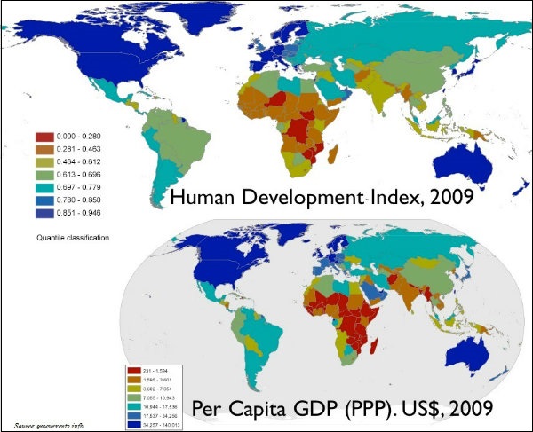
The countries that score more than 0.793, are kept under the category of very high human development index (shown in above in the blue color).
The countries that score between 0.698 and 0.793, are kept under the category of high human development index.
The countries that score between less than 0.522, are kept under the category of low human development index.
Moreover, the political environment of the country and the level of freedom people have is also an important criteria to major human development.
Geography World - International Trade
Introduction
Trade simply means the voluntary exchange of goods and services, where two or more parties are involved.
In the present world, trades are international and national.
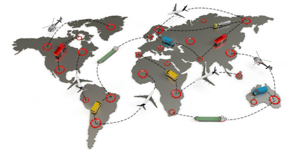
International trade is the exchange of goods and services among countries across national borders.
Barter system was an initial form of trade practiced by the primitive societies.
In the barter system, goods were exchanged directly (no money were required).
Jon Beel Mela, which takes place in Jagiroad, 35 km away from Guwahati in the month of January every year (after the harvest season) possibly, it is the only fair in India, where barter system is still practiced.
The Silk Route is an early example of long distance trade connecting Rome to China travelling about the 6,000 km route.
During the medieval period, the sea route was discovered.
Fifteenth century onwards, the European colonialism began slave trade a new form of trade of human beings.
The slave trade was pretty popular and a lucrative business for more than two hundred years; however, over a period of time, it was abolished - first in Denmark in 1792, and then Great Britain in 1807, and the United States in 1808.
During the World Wars I and II, countries practicing international trade imposed trade taxes and quantitative restrictions.
However, after the war period, organizations like General Agreement for Tariffs and Trade i.e. GATT (which later became the World Trade Organization i.e. WTO), helped in reducing these tariffs imposed on trade of goods and services.
Factors of International Trade
- Major factors of international trade are −
- The difference in national resources,
- Population aspects,
- Stage of economic development,
- The extent of foreign investment
Other Facts
Other infrastructure availability (including transportation and technological factors).
The total value of goods and services traded in a given period of time is known as the volume of trade.
The balance of trade is calculated by taking the difference of the goods and services imported and exported by a country to other countries in a given period of time (normally, in one financial year).
If the value of imports is greater than the value of a countrys exports, the country has a negative or unfavorable balance of trade.
On the other hand, if the value of exports is greater than the value of imports, then the country has a positive or favorable balance of trade.
Bilateral and Multilateral are the two major types of international trade.
Bilateral trade is practiced between two countries on their personal terms and conditions.
Multilateral trade is practiced among many nations (one country can trade with many countries); and, as per the WTO agreement, every WTO member country has to follow the MFN Principle (Most Favored Nation).
The MFN principle restrains the discrimination trade rules and promotes a uniform trading rule with every member country.
The act of opening up economies by removing trade barriers for trading purpose is known as free trade or trade liberalization.
The practice of selling a commodity in two or more countries at a price that differs for reasons not related to costs is called dumping.
Therefore, some countries also need to be cautious about dumped goods; because along with free trade, dumped goods (of cheaper prices) can harm the domestic producers.
After World War II (1948), some of the developed countries founded an international organization namely General Agreement for Tariffs and Trade (GATT).
However, from January 1, 1995, GATT was transformed into the World Trade Organization (WTO).
WTO sets the rules for the global trading system and resolves disputes if any arises between its member nations.
Headquarters of WTO is located in Geneva, Switzerland.
Besides, some Regional Trade Blocs have also formed in order to encourage trade between countries who are located in geographical proximity, similarity, and complementarities in trading items.
The major purpose of regional trade blocks is to curb restrictions on trade of the developing world.
For examples, ASEAN (Association of South East Asian Nations), CIS (Commonwealth of Independent States), NAFTA (North American Free Trade Association), OPEC (Organization of Petroleum Exporting Countries, etc.
The chief gateways of the world of international trade are the harbors and ports.
The ports provide facilities of docking, loading, unloading, and the storage facilities for cargo.
The port specialized in bulk cargo-like grain, sugar, ore, oil, chemicals, and similar materials is known as an industrial port.
The port that handles general cargo-packaged products and manufactured goods is known as a commercial port.
The port, which is located away from the sea coast is known as an inland port. For example, Manchester port, Kolkata port, Memphis port, etc.
The port, which is located away from the actual ports into the deep water is known as an out port. For example, for example, Athens and its out port Piraeus in Greece.
The port which is originally developed as calling point on main sea routes where ships used to anchor for refueling, watering, and taking food items is known as a port of call. For example, Aden, Honolulu, and Singapore.
The port, which is used as the collection center i.e. the goods are brought from different centers (or countries) for export is known as an entrepot port. For example, Rotterdam for Europe, and Copenhagen for the Baltic region.
The following map illustrates the major seaports of the world −
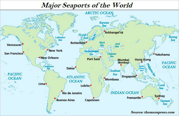
The port that serves the warships and has repair workshops for them is known as a naval port. For example, Kochi and Karwar in India.
The port that exclusively concerned with the transportation of passengers and mail across water bodies (covering short distances) is known as a ferry port.
The following map illustrate the growing trends of trade through ships −