- Geography India - Introduction
- Geography India - Physical Aspect
- Geography India - Drainage System
- Geography India - Climate
- Geography India - Natural Vegetation
- Geography India - National Forest
- Geography India - Wildlife
- Geography India - Soil
- Geography India - Land Resources
- Geography India - Agriculture
- Geography India - Mineral Resources
- Geography India - Energy Resources
- Geography India - Industry
- Geography India - Transport
- Geography India - Communication
- Geography India - Foreign Trade
- Geography India - The People
- Geography India - Settlement
- Geography India - Migration
- Regional Development
- Geography India - Disasters
- Geography of the World
- Geography World - Introduction
- Evolution of the Earth
- Geography World - Climate
- Geography World - Transport
- Geography World - Communications
- Geography World - Population
- Human Settlement
- Human Development
- International Trade
- Geography Useful Resources
- Geography - Online Quiz
- Geography - Online Test
- Geography - Quick Guide
- Geography - Useful Resources
- Geography - Discussion
Geography India - Transport
Introduction
People use various methods to move goods, commodities, ideas from one place to another.
Land, water, and air are the major modes of transportation.
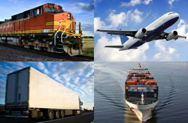
- Land transportation includes road, rail, and pipeline.
Road
With a total length of about 42.3 lakh km, India has one of the largest road networks in the world.
About 85% of passenger and 70% of freight traffic are carried by roads.
Sher Shah Suri built the Shahi (Royal) road to strengthen and consolidate his empire from the Indus Valley to the Sonar Valley in Bengal.
This road was later renamed as the Grand Trunk (GT) Road during the British period, connecting Calcutta and Peshawar.
At present, GT Road extends from Amritsar to Kolkata. It is bifurcated into 2 segments − (a) National Highway (NH)-1 from Delhi to Amritsar, and (b) NH- 2 from Delhi to Kolkata.
Roads have been classified as National Highways (NH), State Highways (SH), Major District Roads, and Rural Roads.
The National Highways Authority of India (NHAI), which is an autonomous body under the Ministry of Surface Transport was operationalized in 1995.
The main roads connecting two or more states are constructed and maintained by the Central Government. These roads are known as the National Highways.
The NHAI is responsible for the development, maintenance, and operation of National Highways.
The National Highways constitute only 1.67 per cent of the total road length, but carry about 40 per cent of the road traffic.
Golden Quadrilateral is 5,846 km long 4/6 lane, high density traffic corridor that connects Indias four big metro cities : Delhi-Mumbai-Chennai-Kolkata.
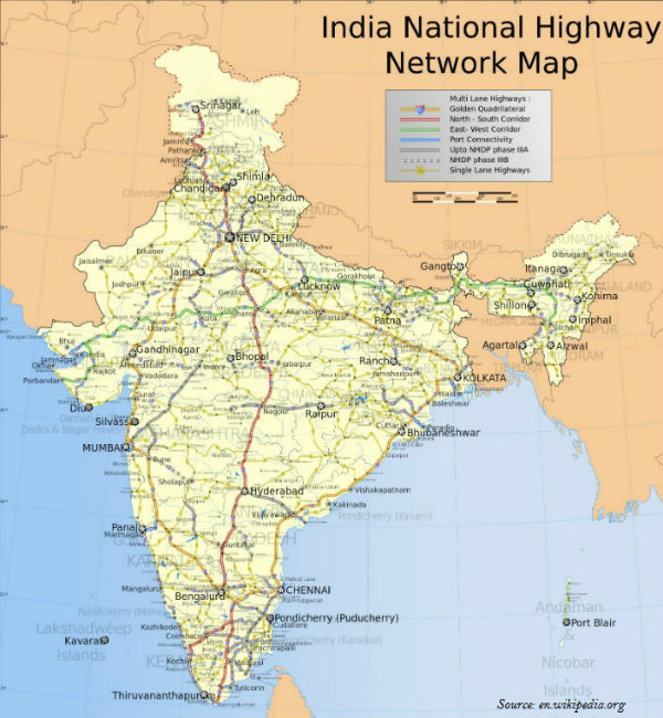
With 4,076 km long road, North-South Corridor aims at connecting Srinagar in Jammu and Kashmir with Kanyakumari in Tamil Nadu.
With 3,640 km of road length, the East-West Corridor has been planned to connect Silchar in Assam with the port town of Porbandar in Gujarat.
State Highways are constructed and maintained by the state governments.
The State Highways join the state capitals with district headquarters and other important towns.
All State Highways collectively constitute about 4 per cent of the total road length in the country.
District roads are the roads connecting the District Headquarters and the other important nodes in the district.
District roads account about 60.83 per cent of the total road length of the country.
Further, about 80 per cent of the total road length in India come under rural roads.
Other roads include Border Roads and International Highways.
The Border Road Organization (BRO) was established in May 1960 for the acceleration of economic development and strengthening defense preparedness through rapid and coordinated improvement of strategically important roads along the northern and north-eastern boundary of the country.
BRO has constructed roads in high altitude mountainous terrain joining Chandigarh with Manali (Himachal Pradesh) and Leh (Ladakh), which runs at an average altitude of 4,270 meters above the mean sea level.
The road density is only 12.14 km in Jammu and Kashmir, whereas in Kerala it is 517.77 km.
Railways
Railways was introduced to India in 1853, when a line was constructed from Bombay to Thane covering a distance of 34 km.
The total length of Indian Railways network is 64460 km. (March 2011).
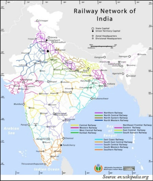
Indian Railways system has been divided into sixteen zones (as shown in the map given below − the lines shown in different colors illustrate the regions of respective zones).
India has three system of railways − broad gauge (the distance between rails is 1.676 meter); meter gauge (the distance between rails is one meter); and narrow gauge (the distance between the rails is 0.762 meter or 0.610 meter).
Konkan Railway constructed along the western coast in 1998, is a landmark achievement of Indian Railway.
Konkan Railway is 760 km long rail route connecting Roha in Maharashtra to Mangalore in Karnataka.
Konkan Railway crosses 146 rivers, streams, nearly 2000 bridges, and 91 tunnels.
Asias largest tunnel which is about 6.5 km long, is constructed on the Konkan railway route near Ratnagiri in Maharashtra.
Waterways
Water transport can be divided into two major categories − inland waterways and oceanic waterways.
India has 14,500 km of navigable waterways, contributing about 1% to the countrys transportation.
Currently, 5,685 km of major rivers is navigable by mechanized flat bottom vessels.
Inland Waterways Authority was set up in 1986 for the development, maintenance, and regulation of national waterways in the country.
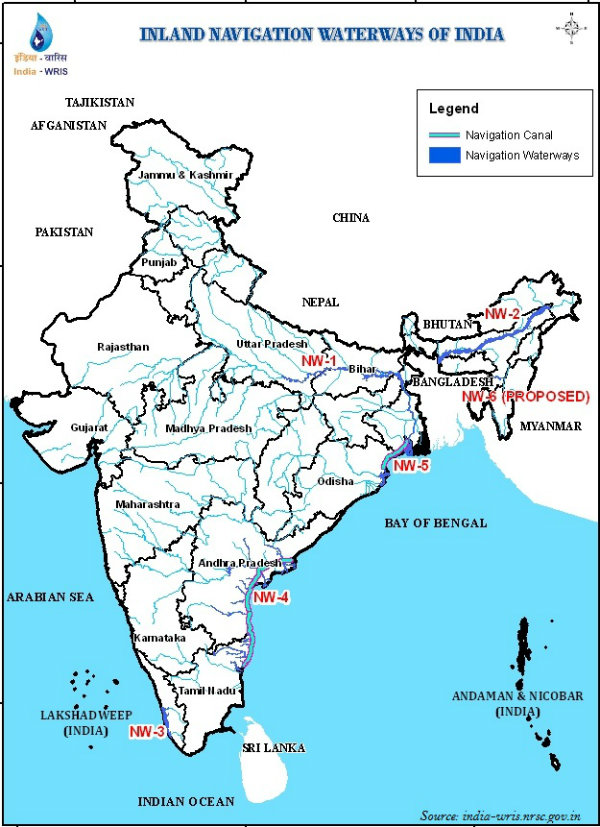
Major National Waterways (NW) of India are NW 1 (Allahabad-Haldia covers 1,620 km); NW 2 (Sadiya-Dhubri covers 891 km); and NW 3 (KottapuramKollam covers 205 km).
Besides, NW 4 covers specified stretches of rivers Godavari and Krishna along with Kakinada Puducherry; the total distance is 1078 km.
NW 5 covers specified stretches of river Brahmani along with Matai river, delta channels of Mahanadi and Brahmani rivers and East Coast canals; the total distance is 588 km.
With 12 major and 185 minor ports, India has a vast coastline of approximate 7,517 km, including islands.
Roughly 95% of Indias foreign trade by volume and 70% by value moves through ocean routes.
Airways
Air transport in India marked its beginning in 1911 with the commencement of airmail over a little distance of 10 km between Allahabad and Naini.
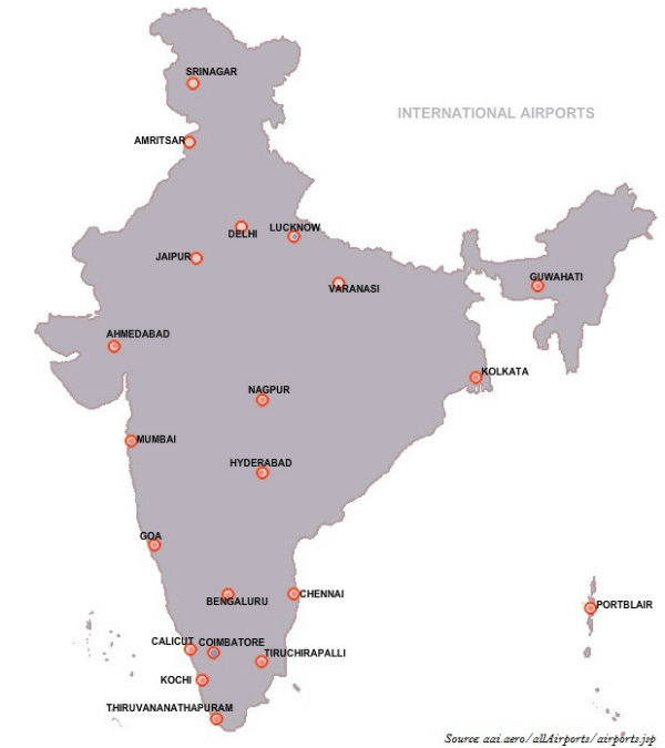
The Airport Authority of India is accountable for providing safe, efficient air traffic, and aeronautical communication services in the Indian Air Space.
Pawan Hans is the helicopter service operating in hilly areas and is widely used by tourists in north-eastern regions.
Pipelin
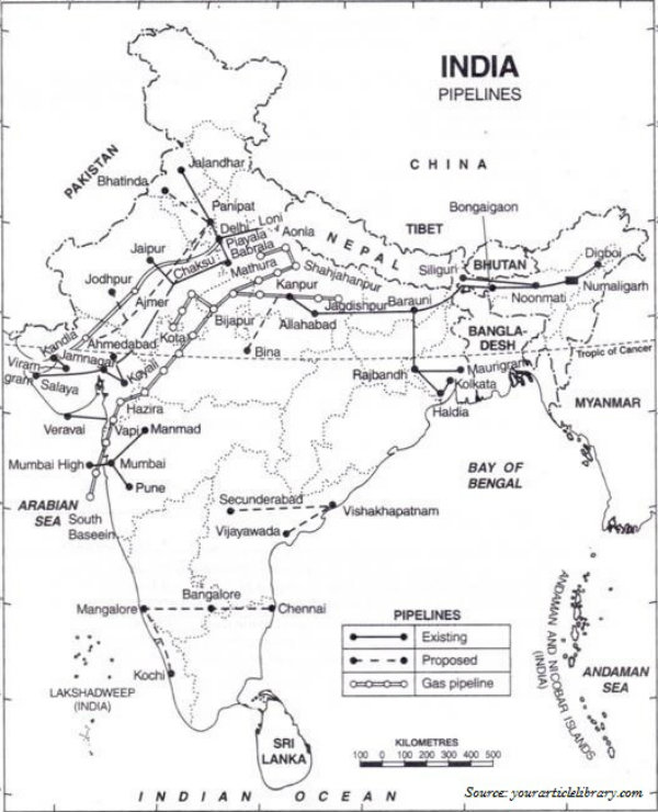
Asias first cross country pipeline covering a distance of 1,157 km was constructed by Oil India Limited (OIL) from Naharkatiya oilfield in Assam to Barauni refinery in Bihar, which further extended up to Kanpur in 1966.
Mumbai High-Koyali and Hazira-Vijaipur-Jagdishpur (HVJ) are the most important pipelines in India.
1256 km long pipeline between Salaya (Gujarat) and Mathura (U.P.) has been constructed recently.
