- Geography India - Introduction
- Geography India - Physical Aspect
- Geography India - Drainage System
- Geography India - Climate
- Geography India - Natural Vegetation
- Geography India - National Forest
- Geography India - Wildlife
- Geography India - Soil
- Geography India - Land Resources
- Geography India - Agriculture
- Geography India - Mineral Resources
- Geography India - Energy Resources
- Geography India - Industry
- Geography India - Transport
- Geography India - Communication
- Geography India - Foreign Trade
- Geography India - The People
- Geography India - Settlement
- Geography India - Migration
- Regional Development
- Geography India - Disasters
- Geography of the World
- Geography World - Introduction
- Evolution of the Earth
- Geography World - Climate
- Geography World - Transport
- Geography World - Communications
- Geography World - Population
- Human Settlement
- Human Development
- International Trade
- Geography Useful Resources
- Geography - Online Quiz
- Geography - Online Test
- Geography - Quick Guide
- Geography - Useful Resources
- Geography - Discussion
Geography India - Drainage System
Introduction
The flow of water through well-defined channels is known as drainage and the network of such channels is known as drainage system.
The drainage pattern of an area is the result of the geological time period, nature, and structure of rocks, topography, slope, etc.
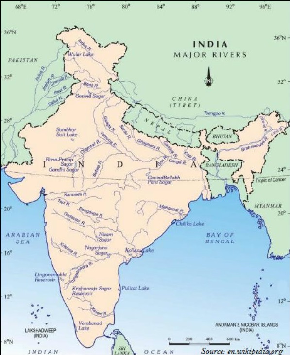
About 77% of the drainage area consisting of the Ganga, the Brahmaputra, the Mahanadi, the Krishna, etc. is oriented towards the Bay of Bengal.
On the other hand, 23% comprising the Indus, the Narmada, the Tapi, the Mahi, and the Periyar systems discharge their waters in the Arabian Sea.
A river drain is a specific area, which is known as the catchment area of that river.
An area drained by a river and its tributaries is known as a drainage basin.
The boundary line separating one drainage basin from the other is called as the watershed area.
Drainage Pattern
Following are the major drainage patterns −
Dendritic
Radial
Centripetal
Trellis
A drainage pattern which looks like tree branches with lots of twigs is known as Dendritic drainage pattern. For example, the rivers of northern plain.
Radial drainage patterns form when rivers originate from a hill and flow in all directions. For example, the rivers originating from the Amarkantak.
Centripetal drainage pattern is formed when rivers discharge their waters from all directions into a lake or a depression. For example, Loktak lake in Manipur.
Trellis drainage pattern is formed when the primary tributaries of main rivers flow parallel to each other and secondary tributaries join them at right angles. For example, rivers in the upper part of the Himalayan region.
Classification of Drainage
On the basis of the mode of origin, nature, and characteristics, the Indian drainage is classified as −
The Himalayan drainage and
The Peninsular drainage.
Himalayan Drainage
Major Himalayan drainage systems are the Indus, the Ganga, and the Brahmaputra rivers.
The Indus
The total length of the Indus River system is 2,880 km (in India 1,114 km).
The Indus, which is also known as the Sindhu, is the westernmost of the Himalayan Rivers in India.
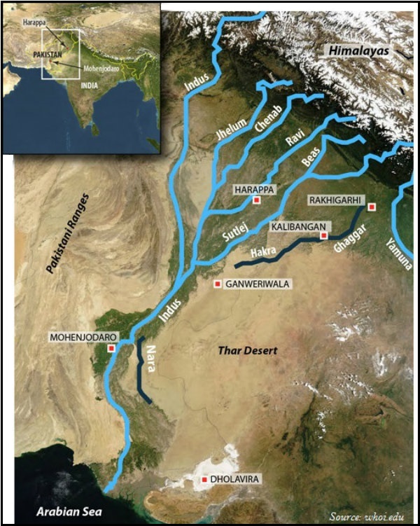
The Indus originates from a glacier near Bokhar Chu in the Tibetan region at an altitude of 4,164 m in the Kailash Mountain range.
In Tibet, the Indus is known as Singi Khamban or the Lions mouth.
The Indus enters into Pakistan near Chillar in the Dardistan region.
Major tributaries of Indus are the Shyok, the Gilgit, the Zaskar, the Hunza, the Nubra, the Shigar, the Gasting, and the Dras in the upper part.
In the lower part, the Satluj, the Beas, the Ravi, the Chenab, and the Jhelum are the major tributaries of the Indus.
Finally, the Indus discharges into the Arabian Sea near Karachi in Pakistan.
The Jhelum, an important tributary of the Indus, rises from a spring at Verinag situated at the foot of the Pir Panjal.
The Jhelum flows through Srinagar and the Wular Lake before entering into Pakistan.
Jhelum joins the Chenab near Jhang in Pakistan.
Formed by two streams i.e. the Chandra and the Bhaga, the Chenab is the largest tributary of the Indus.
Chenab is also known as Chandrabhaga.
The Chenab flows about 1,180 km before entering into Pakistan.
Originating from the Rohtang pass in the Kullu hills of Himachal Pradesh and flowing through the Chamba valley of the state, Ravi is one of the important tributaries of the Indus.
Originating from the Beas Kund near the Rohtang Pass at an elevation of 4,000 m above the mean sea level, Beas is also an important tributaries of the Indus.
Beas enters into the Punjab plains and meets with the Satluj near Harike.
Also popular as Langchen Khambab (in Tibet), the Satluj originates from the Rakas lake near Mansarovar at an altitude of 4,555 m in Tibet.
The Satluj passes through the Shipki La on the Himalayan ranges and enters into the Punjab plains.
The Satluj is the river that feeds the canal system of the Bhakra Nangal project.
The Ganga
The Ganga originates from the Gangotri glacier near Gaumukh (3,900 m) in the Uttarkashi district of Uttarakhand.
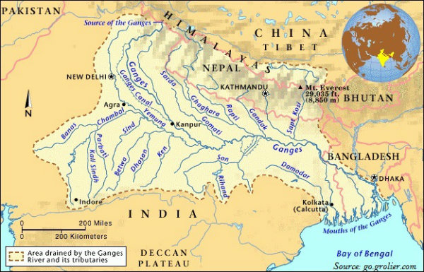
However, the river, when it originates from the Gangotri glacier is known as the Bhagirathi.
At Devprayag, the Bhagirathi merges with another river, i.e., the Alaknanda; and from here, it is known as the Ganga.
The Alaknanda originates from the Satopanth glacier above Badrinath.
The major tributaries of the Alaknanda are the Dhauli and the Vishnu Ganga; these two rivers meet at Joshimath/Vishnu Prayag.
Some other tributaries of the Alaknanda are the Pindar (joins at Karna Prayag), the Mandakini or Kali Ganga (joins at Rudra Prayag).
The total length of the Ganga in India is 2,525 km, which is shared by Uttarakhand (110 km); Uttar Pradesh (1,450 km); Bihar (445 km); and West Bengal (520 km).
The Ganga river system is the largest river system in India.
The Son is a major right bank tributary of the Ganga; however, major left bank tributaries are the Ramganga, the Gomati, the Ghaghara, the Gandak, the Kosi, and the Mahananda.
Originating from the Yamunotri glacier on the western slopes of Banderpunch range (6,316 km), the Yamuna is the longest tributary of the Ganga.
The Yamuna joins the Ganga at Allahabad (Prayag), Uttar Pradesh.
The Chambal, the Sind, the Betwa, and the Kenon are the right bank tributaries of the Yamuna and the Hindan, the Rind, the Sengar, the Varuna, etc. are the left bank tributaries.
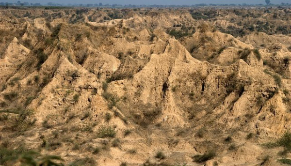
The Chambal rises near Mhow in the Malwa plateau of Madhya Pradesh.
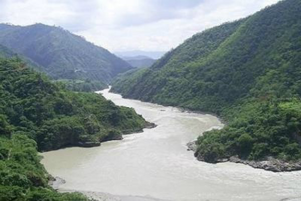
The Chambal is famous for its badland topography, known as the Chambal ravines (as shown in the image given below).
Originating from the Nepal Himalayas between the Dhaulagiri and Mount Everest, the Gandak consists of two streams, namely Kaligandak and Trishulganga.
The Gandak joins the Ganga at Sonpur near Patna, Bihar.
The Ghaghara originates from the Mapchachungo glaciers and joins the Ganga at Chhapra, Bihar.
The Kosi originates from the north of Mount Everest in Tibet where it is known as the Arun.
Originating from the Garhwal hills near Gairsain, the Ramganga joins the Ganga near Kannauj.
The Damodar drains the eastern margins of the Chottanagpur plateau, where it flows through a rift valley and finally joins the Hugli.
The Barakar is the main tributary of the Damodar.
The Sarda or Saryu River rises from the Milam glacier in the Nepal Himalayas where it is known as the Goriganga. However, along the Indo-Nepal border, it is called as Kali or Chauk, where it joins the Ghaghara.
Originating from the Darjeeling hills, the Mahananda joins the Ganga as its last left bank tributary in West Bengal.
Originating from the Amarkantak plateau, the Son is a large south bank tributary of the Ganga; it joins the Ganga at Arrah, Bihar.
The Brahmaputra
The Brahmaputra originates from the Chemayungdung glacier of the Kailash range near the Mansarovar Lake.
In Tibet, the Brahmaputra is known as the Tsangpo (means the purifier).
The Rango Tsangpo is the major right bank tributary of the Brahmaputra in Tibet.
The Brahmaputra enters into India near the west of Sadiya town in Arunachal Pradesh.
Major left bank tributaries of the Brahmaputra are Lohit, Dibang or Sikang, Burhi Dihing, and Dhansari.
Major right bank tributaries of the Brahmaputra are the Subansiri, Kameng, Manas, and Sankosh.
The Tista joins the Brahmaputra on its right bank in Bangladesh and from here, the river is known as the Yamuna.
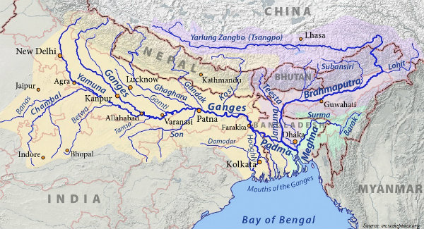
Finally, the Brahmaputra merges with the river Padma and falls in the Bay of Bengal.
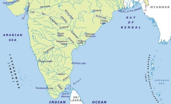
Peninsular River System
The Peninsular drainage system is older than the Himalayan Rivers.
The Mahanadi originates from Sihawa in Raipur district of Chhattisgarh and runs through Madhya Pradesh and Odisha and finally discharges its water into the Bay of Bengal.
The total length of Mahanadi is 851 km.
Popularly known as the Dakshin Ganga, the Godavari is the largest peninsular river system.
The Godavari originates from Nasik district of Maharashtra and discharges its water into the Bay of Bengal.
With total 1,465 km length, Godavari covers the areas of Maharashtra, Madhya Pradesh, Chhattisgarh, Odisha, and Andhra Pradesh.
The Penganga, the Indravati, the Pranhita, and the Manjra are the major tributaries of Godavari.
Originating from Mahabaleshwar in Sahyadri, the Krishna is the second largest east flowing Peninsular River.
The Koyna, the Tungabhadra, and the Bhima are the major tributaries of the Krishna.
Of the total catchment area of the Krishna, 27% lies in Maharashtra, 44% in Karnataka, and 29% in Andhra Pradesh.
The Kaveri originates from the Brahmagiri hills (1,341m) located in Kogadu district of Karnataka.
The river Kaveris total course of 770 km commands a basin area of 8.8 million hectare mha, of which, 3% lies in Kerala, 41% lies in Karnataka, and 56% lies in Tamil Nadu.
Major tributaries of the Kaveri are the Kabini, the Bhavani, and the Amravati.
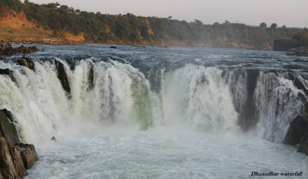
The Narmada originates from the western flank of the Amarkantak plateau (1,057 m).
Flowing through a rift valley located between the Satpura in the south and the Vindhya range in the north, the Narmada forms Dhuandhar waterfall and a picturesque gorge of marble rocks nearby Jabalpur.
The total length of Narmada is 1,312 km.
Flowing in the westward direction, Narmada finally empties into the Arabian Sea in the Bharuch district of Gujarat.
Originating from Multai in the Betul district of Madhya Pradesh, Tapi is the other important westward flowing river emptying into the Arabian Sea.
About 79% of the Tapi basin lies in Maharashtra, 15% in Madhya Pradesh, and the remaining 6% in Gujarat.
Luni is the longest river system of Rajasthan.
Primarily, Luni originates in the Pushkar valley of the Aravalli range, Rajasthan in two branches, i.e. the Saraswati and the Sabarmati; which join each other at Govindgarh. From here, the river is known as Luni.
Luni finally debouches into the Arabian Sea nearby the Rann of Kachchh.
Some small rivers flowing towards the West are the Shetruniji, the Bhadra, Dhadhar, Sabarmati, Mahi, Vaitarna, Kalinadi, Dedti, Sharavati, Mandovi, Juari, Bharathapuzha, Periyar, etc.
Some small rivers flowing towards the East are Subarnarekha, Baitarni, Brahmani, Penner, and Palar.
The following table illustrates the major differences between Himalayan and the Peninsular River system −
| Characteristics | Himalayan River | Peninsular River |
|---|---|---|
| Place of origin | Himalayan mountains (covered with glaciers). | Peninsular plateau and central highland. |
| Nature of flow | Perennial; receive water from glacier and rainfall. | Seasonal; dependent on monsoon rainfall. |
| Type of drainage | Antecedent and consequent leading to dendritic pattern in plains. | Super imposed, rejuvenated resulting in trellis, radial, and rectangular patterns. |
| Nature of river | Long course, flowing through the rugged mountains experiencing head ward erosion and river capturing; In plains, meandering and shifting off course. | Smaller, fixed course with welladjusted valleys. |
| Catchment area | Very large basin. | Relatively smaller basin. |
| Age of the river | Young and youthful, active and deepening in the valleys | Old rivers with graded profile, and have almost reached their base levels. |
