- Geography India - Introduction
- Geography India - Physical Aspect
- Geography India - Drainage System
- Geography India - Climate
- Geography India - Natural Vegetation
- Geography India - National Forest
- Geography India - Wildlife
- Geography India - Soil
- Geography India - Land Resources
- Geography India - Agriculture
- Geography India - Mineral Resources
- Geography India - Energy Resources
- Geography India - Industry
- Geography India - Transport
- Geography India - Communication
- Geography India - Foreign Trade
- Geography India - The People
- Geography India - Settlement
- Geography India - Migration
- Regional Development
- Geography India - Disasters
- Geography of the World
- Geography World - Introduction
- Evolution of the Earth
- Geography World - Climate
- Geography World - Transport
- Geography World - Communications
- Geography World - Population
- Human Settlement
- Human Development
- International Trade
- Geography Useful Resources
- Geography - Online Quiz
- Geography - Online Test
- Geography - Quick Guide
- Geography - Useful Resources
- Geography - Discussion
Geography India - Regional Development
Introduction
India has centralized planning and the task of planning in India has been entrusted to the Planning Commission of India.
Planning Commission of India is a statutory body headed by the Prime Minister and has a Deputy Chairman and other members.
However, the Planning Commission of India is recently is now National Institution for Transforming India or simply NITI Aayog.
The planning in the country is largely carried out through the array of Five Year Plans.
At present, the Twelfth Five Year Plan is running, which was initiated in 2012 with a focus on Faster, More Inclusive and Sustainable Growth.
Approaches of Planning
Normally, there are two approaches of planning. They are −
Sectoral planning
Regional planning.
Sectoral Planning
Sectoral planning means formulation and implementation of the sets of schemes or programs aimed at development of various sectors of the economy such as agriculture, irrigation, manufacturing, power, construction, transport, communication, social infrastructure, and services.
Regional Planning
Since all the regions of India have not developed on the same lines, therefore, to reduce the regional imbalances, regional planning was introduced.
Target Area Planning
In order to reduce the regional and social disparities, the Planning Commission introduced the target area and target group approaches to planning.
Some of the examples of target area planning directed towards the development of target areas are −
Command Area Development Program;
Drought Prone Area Development Program;
Desert Development Program; and
Hill Area Development Program.
The examples of target area planning are − the Small Farmers Development Agency (SFDA) and Marginal Farmers Development Agency (MFDA).
Hill Area Development Programs were initiated during the Fifth Five Year Plan. The plan covers 15 districts comprising all the hilly districts of Uttarakhand, Mikir Hill and North Cachar hills of Assam, Darjeeling district of West Bengal and Nilgiri district of Tamil Nadu.
Major aims of Hill Area Development Program were harnessing the indigenous resources of the hilly areas through the development of horticulture, plantation agriculture, animal husbandry, poultry, forestry, and small-scale and village industry.
Drought Prone Area Program was initiated during the Fourth Five-Year Plan with the objectives of providing employment to the people in droughtprone areas and creating productive assets.
The drought prone area in India largely covers semi-arid and arid tract of Rajasthan; Gujarat; Western Madhya Pradesh; Marathwada region of Maharashtra; Rayalseema and Telangana plateaus of Andhra Pradesh & Telangana; Karnataka plateau; and highlands and interior parts of Tamil Nadu.
Planning Facts
In 1967, the Planning Commission of India identified 67 districts (entire or partly) of the country prone to drought.
In 1972, the Irrigation Commission introduced the criterion of 30% irrigated area and demarcated the drought prone areas.
In 1970s, the phrases such as redistribution with growth and growth and equity were incorporated in the definition of development.
Over period of time, the meaning of Development did not remain restricted to economic growth rather it also includes the issues such as improving the wellbeing and living standard of the people; availing the health facilities; education; equality of opportunity; and ensuring political and civil rights.
The concept of sustainable development emerged in the wake of general rise in the awareness of environmental issues in the late 1960s in the Western World.
The publication of The Population Bomb by Ehrlich in 1968 and The Limits to Growth by Meadows at al in 1972 further raised the environmental concerns.
The United Nations established a World Commission on Environment and Development (WCED) headed by the Norwegian Prime Minister Gro Harlem Brundtland. This is the reason that its report submitted in 1987 with the name Our Common Future, is also known as Brundtland Report.
In this report, sustainable development is defined as − development that meets the needs of the present without compromising the ability of future generations to meet their own needs.
Likewise, Sustainable development takes care of ecological, social, and economic aspects of the development during the present times and pleads for conservation of resources to enable the future generations to use these resources.
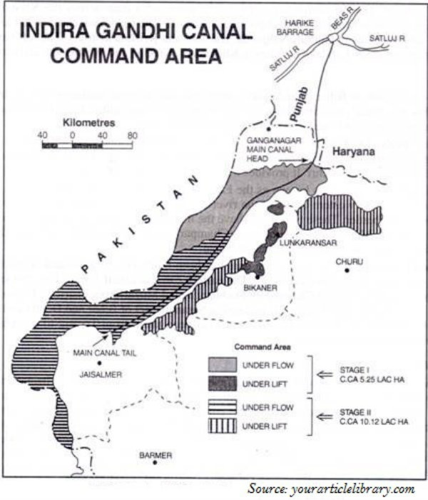
Indira Gandhi Canal, which previously was popular as the Rajasthan Canal, is one of the largest canal systems in India.
The idea of Indira Gandhi Canal was proposed by Kanwar Sain in 1948; however, the canal project was launched on 31 March, 1958.
The canal originates at Harike barrage in Punjab and runs parallel to Pakistan border and covers an average distance of 40 km in Thar Desert of Rajasthan.
