- Geography India - Introduction
- Geography India - Physical Aspect
- Geography India - Drainage System
- Geography India - Climate
- Geography India - Natural Vegetation
- Geography India - National Forest
- Geography India - Wildlife
- Geography India - Soil
- Geography India - Land Resources
- Geography India - Agriculture
- Geography India - Mineral Resources
- Geography India - Energy Resources
- Geography India - Industry
- Geography India - Transport
- Geography India - Communication
- Geography India - Foreign Trade
- Geography India - The People
- Geography India - Settlement
- Geography India - Migration
- Regional Development
- Geography India - Disasters
- Geography of the World
- Geography World - Introduction
- Evolution of the Earth
- Geography World - Climate
- Geography World - Transport
- Geography World - Communications
- Geography World - Population
- Human Settlement
- Human Development
- International Trade
- Geography Useful Resources
- Geography - Online Quiz
- Geography - Online Test
- Geography - Quick Guide
- Geography - Useful Resources
- Geography - Discussion
Geography India - The People
Introduction
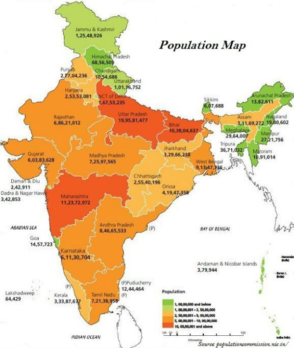
Throughout the country, India has a highly uneven pattern of the population distribution.
Uttar Pradesh has the highest population followed by Maharashtra, Bihar, and West Bengal.
Terrain, climate, and availability of water largely determine the pattern of the population distribution. However, socio-economic and historical factors also affect the pattern of population distribution.
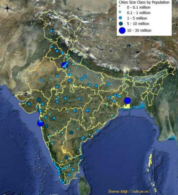
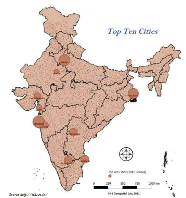
As per the 2011 census, urban population of India was 31.16% (the details of major urban center is illustrated in the following map).
As per census 2011, the annual population growth rate is 1.64 percent.
Population Density
The density of population is expressed as the number of persons per unit area.
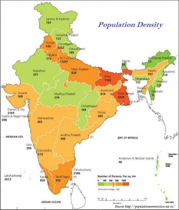
The density of population in India as per 2011 census is 382 persons per square km.
Bihar with 1102 people per square km is the most densely populated state of India followed by West Bengal (1029) and Uttar Pradesh (828).
Physiological density refers to the total population divided by the net cultivated area.
Agricultural density refers to the total agricultural population divided by the net cultivable area.
Agricultural population includes cultivators and agricultural laborers and their family members.
Phases of Population Growth
Indias population can be analyzed in four phases −
Phase I, the period between 1901 and 1921 − This period is known as stagnancy period, as the birth rate and death rate both were high and the population growth rate was very slow.
Phase II, the period between 1921 and 1951 − It was the period of steady population growth.
Phase III, the period between 1951 and 1981 − It was the period of population explosion in India.
Phase IV, from 1981 to till date − Population growth rate though still high, but reflecting a decreasing trend.
Population Composition
As per census 2011, 68.8 per cent of the total population lives in village and 31.2 per cent of the population lives in urban areas.
Considering the economic status, population can be divided into categories such as main workers, marginal workers, and non-workers.
As per the census 2011, main workers and marginal workers collectively constitute only about 39.8 percent of total population; rest are non-workers.
About 54.6 per cent of the total working population are cultivators and agricultural laborers
About 41.6 % are other workers, such as non-household industries, trade, commerce, construction, repair, and other services.
The number of female workers is relatively high in the primary sector.
The proportion of workers in agricultural sector in India has shown a declining trend over the last few decades; in 2001, it was 58.2%, whereas, in 2011, it was 54.6%.
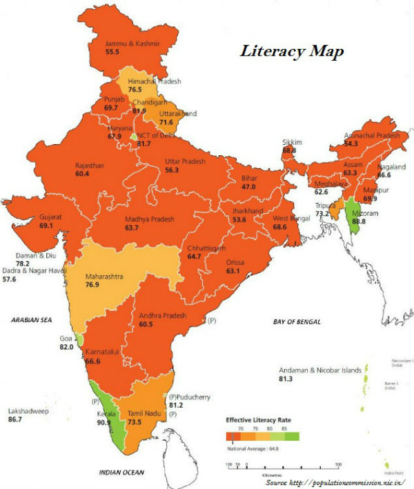
Literacy
As per the 2011 census, literacy rate of India was 74.04% (the details of literacy rate is illustrated in the following map − state-wise).
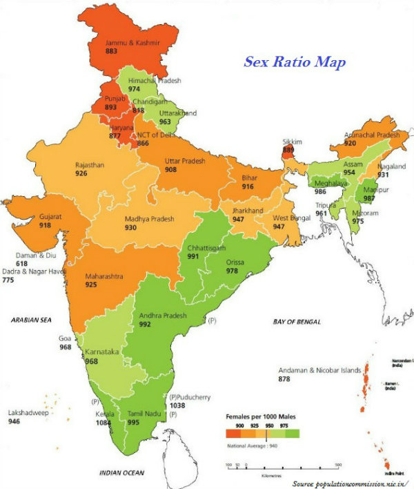
Sex Ratio
As per the 2011 census, sex ratio of India was 940 females per 1000 males (the details of sex ratio is illustrated in the following map − state-wise).
Languages
In India, there are 22 scheduled languages and hundreds of non-scheduled languages.
Among the scheduled languages, Hindi is the highest spoken language and Kashmiri and Sanskrit have the least number of speakers.
| Family | Sub-Family | Spoken Region |
|---|---|---|
Austric (Nishada) 1.38% |
Austro-Asiatic Austro-Nesian |
Meghalaya, Nicobar Islands, West Bengal, Bihar, Odisha, Assam, Madhya Pradesh, Maharashtra |
Dravidian (Dravida) 20% |
Tamil Nadu, Karnataka, Kerala, Andhra Pradesh, M.P., Odisha, Maharashtra, Bihar | |
Sino-Tibetan (Kirata), 0.85% |
TibetoMyanmari Siamese-Chinese |
Jammu & Kashmir, Himachal Pradesh, Sikkim, Arunachal Pradesh, Assam, Nagaland, Manipur, Mizoram, Tripura, Meghalaya |
IndoEuropean (Aryan) 73% |
Indo-Aryan | Jammu & Kashmir, Jammu & Kashmir, Punjab, Himachal Pradesh, U.P., Rajasthan, Haryana, M.P., Bihar, Odisha, West Bengal, Assam, Gujarat, Maharashtra, Goa. |
Religions
Religion is one of the most integral parts of the population composition of India.
More than 80 percent of the population comprises of Hindus followed by Muslims, Christians, Sikhs, Buddhists, and Jains.
