- Geography India - Introduction
- Geography India - Physical Aspect
- Geography India - Drainage System
- Geography India - Climate
- Geography India - Natural Vegetation
- Geography India - National Forest
- Geography India - Wildlife
- Geography India - Soil
- Geography India - Land Resources
- Geography India - Agriculture
- Geography India - Mineral Resources
- Geography India - Energy Resources
- Geography India - Industry
- Geography India - Transport
- Geography India - Communication
- Geography India - Foreign Trade
- Geography India - The People
- Geography India - Settlement
- Geography India - Migration
- Regional Development
- Geography India - Disasters
- Geography of the World
- Geography World - Introduction
- Evolution of the Earth
- Geography World - Climate
- Geography World - Transport
- Geography World - Communications
- Geography World - Population
- Human Settlement
- Human Development
- International Trade
- Geography Useful Resources
- Geography - Online Quiz
- Geography - Online Test
- Geography - Quick Guide
- Geography - Useful Resources
- Geography - Discussion
Geography India - Disasters
Introduction
Disaster is an undesirable catastrophe resulting from the forces that are largely beyond human control, strikes quickly with little or no warning, and causes or threatens serious disruption of life and property. For example, earthquake, tsunami, cyclone, flood, etc.

Disasters are normally caused by nature (beyond human control); however, there are many human-induced disasters. For example, Bhopal Gas tragedy, Chernobyl nuclear disaster, wars, release of CFCs (Chlorofluorocarbons), releasing greenhouse gases, etc.
Besides, some disasters are natural in occurence, but those are indirectly caused by human activities. For example, landslides in hilly regions, droughts, and floods due to deforestation and other environmental damage.
On the other hand, Natural Hazards are the elements of circumstances in the Natural environment that have the potential to harm people or property or both.
The disasters are global in nature; hence, to combat with it, the United Nations made a systematic strategy at the World Conference on Disaster Management held in May 1994 at Yokohama, Japan.
The Yokohama conference however, is popular as the Yokohama Strategy and Plan of Action for a Safer World.
Categories of Natural Disaster
Natural Disasters are broadly categorized as −
Atmospheric Disasters
Terrestrial Disasters
Aquatic Disasters
Biological Disasters
Atmospheric disasters include blizzard, thunderstorm, lightning, tropical cyclone, tornado, drought, hailstorm, frost, heat wave, cold waves, etc.
Terrestrial disasters include earthquake, volcanic eruption, landslide, avalanches, subsidence, etc.
Aquatic disasters include flood, tidal waves, storm surge, tsunami, etc.
Biological disasters include fungal, bacterial, and viral diseases (e.g. bird flu, dengue, etc.).
Disasters Zone

Very High Damage Earthquake Risk Zone in India include the north-eastern regions, areas to the north of Darbhanga and Araria along the Indo-Nepal border in Bihar, Uttarakhand, Western Himachal Pradesh (around Dharamshala) and Kashmir Valley in the Himalayan region, and the Kachchh (Gujarat).
High Damage Earthquake Risk Zone in India are parts of Jammu and Kashmir, Himachal Pradesh, Northern parts of Punjab, Eastern parts of Haryana, Delhi, Western Uttar Pradesh, and Northern Bihar.
Earthquakes and volcanic eruptions normally cause the sea-floor to move abruptly resulting in sudden displacement of ocean water in the form of high vertical waves, which are known as tsunamis (shown in the image given below).

Tsunamis can be observed frequently along the Pacific ring of fire, particularly along the coast of Alaska, Japan, Philippines, and other islands of Southeast Asia, Indonesia, Malaysia, Myanmar, Sri Lanka, and India etc.
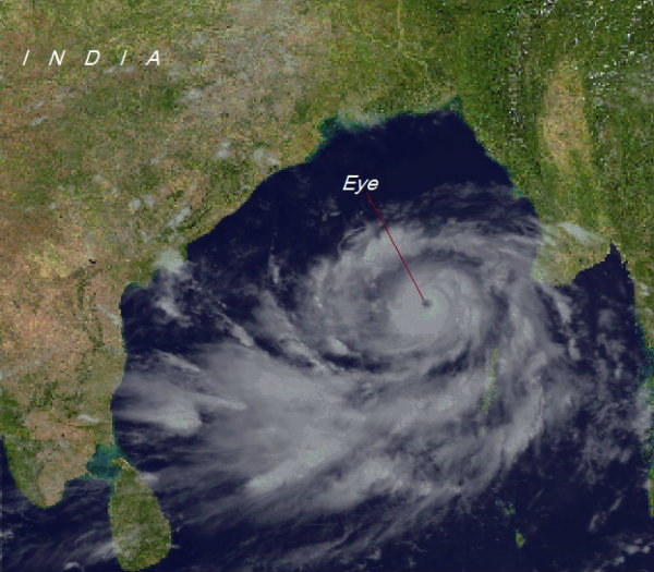
Tropical cyclones are intense low-pressure areas, confined between $30^{\circ}N$ and $30^{\circ}S$ latitudes.

The center of the cyclone is mostly a warm and low-pressure, cloudless core known as eye of the storm (as shown in the image below) −
The ideal location of the tropical cyclone in India is Bay of Bengal.
Cyclones in the Bay of Bengal normally develop in the months of October and November.
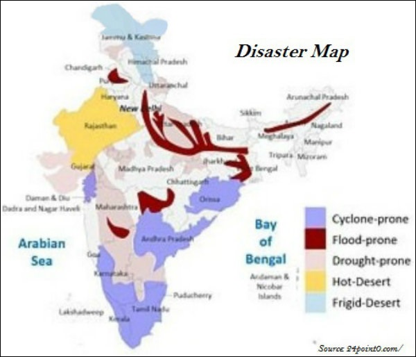
Rashtriya Barh Ayog (National Flood Commission) identified 40 million hectares of land as flood-prone in India.
Assam, West Bengal, and Bihar are the high flood-prone states of India.
About 30 per cent of Indias total area comes under drought prone area, which affects about 50 million people.
The western part of Rajasthan is categorized as Extreme Drought Affected Areas.
Parts of eastern Rajasthan; many parts of Madhya Pradesh; eastern parts of Maharashtra; interior parts of Andhra Pradesh and Karnataka Plateau; northern parts of interior Tamil Nadu; southern parts of Jharkhand; and interior parts of Odisha are categorized as Severe Drought Prone Area.
Young mountainous areas of North and north-eastern India (the Himalayan regions), Andaman and Nicobar; high rainfall regions with steep slopes in the Western Ghats and Nilgiris; along with areas of frequent earthquakes, etc. are categorized as Very High Landslide Vulnerability Zone.
Disaster Management
The Disaster Management Bill, 2005, defines disaster as a catastrophe, mishap, calamity or grave occurrence affecting any area, arising from natural or man-made causes, or by accident or negligence which results in substantial loss of life or human suffering or damage to, and destruction of, environment, and is of such nature or magnitude as to be beyond the coping capacity of the community of the affected area.
A situation when there is a prolonged period of inadequate rainfall is known as Meteorological Drought.
When soil moisture that is necessary to support the crops, is low or insufficient to support crop cultivation, it is known as Agricultural Drought.
When the productivity of a natural ecosystem fails because of the shortage of water and as a consequence of ecological distress, damages occur in the ecosystem, it is known as Ecological Drought.