- Geography India - Introduction
- Geography India - Physical Aspect
- Geography India - Drainage System
- Geography India - Climate
- Geography India - Natural Vegetation
- Geography India - National Forest
- Geography India - Wildlife
- Geography India - Soil
- Geography India - Land Resources
- Geography India - Agriculture
- Geography India - Mineral Resources
- Geography India - Energy Resources
- Geography India - Industry
- Geography India - Transport
- Geography India - Communication
- Geography India - Foreign Trade
- Geography India - The People
- Geography India - Settlement
- Geography India - Migration
- Regional Development
- Geography India - Disasters
- Geography of the World
- Geography World - Introduction
- Evolution of the Earth
- Geography World - Climate
- Geography World - Transport
- Geography World - Communications
- Geography World - Population
- Human Settlement
- Human Development
- International Trade
- Geography Useful Resources
- Geography - Online Quiz
- Geography - Online Test
- Geography - Quick Guide
- Geography - Useful Resources
- Geography - Discussion
Geography India - Physical Aspect
India - Evolution
As per the estimation, the earth is approximately 460 million years old.
The endogenic and exogenic forces played a significant role in giving shape to various surface and subsurface features of the earth.
The theory of Plate Tectonics defines the formation of physical aspects of the earth.
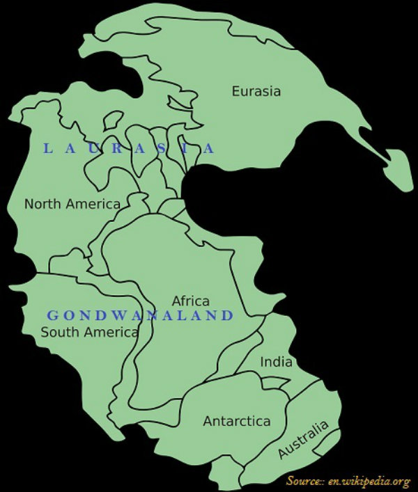
Initially, all continents were united (there was one landmass), and known as Pangea or Super Continent (as shown in the image given below).
The northern part of the ancient super continent Pangea was named as Angara Land or Laurasia and the southern part was named as Gondwana Land.
The Gondwana Land includes India, Australia, South Africa, South America, and Antarctica.
India - Structure
Based on geological history, India is divided into three regions. The regions are −
The Peninsular Block;
The Himalayas & other Peninsular Mountains; and
Indo-Ganga-Brahmaputra Plain.
The Peninsular Block is formed essentially by a great complex of very ancient gneisses and granites.
The Peninsular Block mostly consists of relicts and residual mountains like the Aravali hills, the Nallamala hills, the Javadi hills, the Veliconda hills, the Palkonda range, the Mahendragiri hills, etc.
Unlike the rigid and stable Peninsular Block, the Himalayan Mountains are young, weak, and flexible in their geological structure.
Indo-Ganga-Brahmaputra Plain comprises the plains formed by the river Indus, the Ganga, and the Brahmaputra.
In fact, Indo-Ganga-Brahmaputra Plain is a geo-synclinal depression, which attained its maximum development during the third phase of the Himalayan mountain formation, approximately about 64 million years ago.
Physiography
Indias physiography is divided into six following regions −
The Northern and Northeastern Mountains
The Northern Plain
The Peninsular Plateau
The Indian Desert
The Coastal Plains
The Islands
Northern and Northeastern Mountains
The Northern and the Northeastern Mountains consist of the Himalayas and the Northeastern hills.
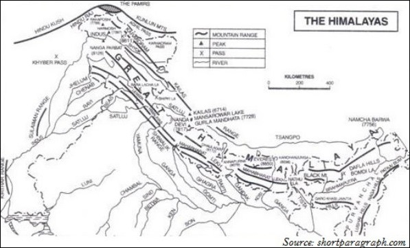
The Himalayan Ranges include the Greater Himalaya, Lesser/Middle Himalaya, and the Siwalik Range.
Based on relief, alignment of ranges and other geomorphological features, the Himalayas can be divided into the following sub-divisions −
Kashmir or Northwestern Himalayas
Himachal and Uttaranchal Himalayas
Darjeeling and Sikkim Himalayas
Arunachal Himalayas
Eastern Hills and Mountains.
Kashmir or Northwestern Himalayas
Kashmir or Northwestern Himalayas consist of a series of ranges such as the Karakoram, Ladakh, Zanskar, and Pir Panjal.
Important glaciers of South Asia, i.e., the Baltoro and Siachen are found in the Northwestern Himalayan region.
The Kashmir Himalayas are also popular for the Karewa formations, which are useful for the cultivation of Zafran, a local variety of saffron.
Karewas are the thick deposits of glacial clay and other materials embedded with moraines.
Important passes of the Northwestern Himalayas are Zoji La on the Great Himalayas, Banihal on the Pir Panjal, and Khardung La on the Ladakh range.
Important fresh lakes are Dal and Wular and salt water lakes are Pangong Tso and Tso Moriri.
The southernmost part of the Northwestern Himalayas consists of longitudinal valleys locally known as duns.
Himachal and Uttaranchal Himalayas
The Himachal and Uttarakhand Himalayas are located approximately between the rivers Ravi in the west and the Kali (a tributary of Ghaghara) in the east.
Darjeeling and Sikkim Himalayas
The Darjeeling and Sikkim Himalayas are flanked by the Nepal Himalayas in the west and the Bhutan Himalayas in the east.
Arunachal Himalayas
The Arunachal Himalayas extend from the east of the Bhutan Himalayas up to the Diphu pass in the east.
Some of the prominent tribes of Arunachal Himalayas from west to east are the Monpa, Abor, Mishmi, Nyishi, and the Nagas.
Eastern Hills and Mountains
Located in the northeast India, the Eastern Hills i.e. parts of the Himalayan mountains are known by different local names. They are known as Patkai Bum, Naga hills, the Manipur hills in the North, and Mizo or Lushai hills in the South.
Northern Plains
The northern plains are formed by the alluvial deposits brought by the rivers − the Indus, the Ganga, and the Brahmaputra.
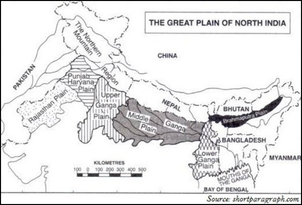
The northern plains are divided into three major zones − the Bhabar, the Tarai, and the alluvial plains.
Bhabar is a narrow belt spread between 8-10 km parallel to the Shiwalik foothills at the break-up of the slope where all the rivers coming through this way deposit heavy materials of rocks and boulders and get disappeared.
These streams again re-emerge in Tarai region.
The south of Tarai is a belt consisting of old and new alluvial deposits known as the Bhangar and Khadar accordingly.
The alluvial plains are further divided as the Khadar and the Bhangar.
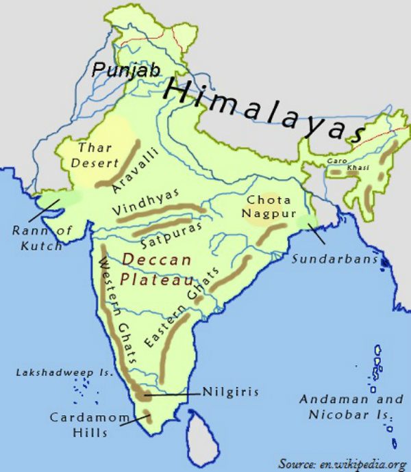
Peninsular Plateau
The Peninsular Block is made up of a series of patland plateaus such as the Hazaribagh plateau, the Palamu plateau, the Ranchi plateau, the Malwa plateau, the Coimbatore plateau, and the Karnataka plateau.
Delhi ridge in the northwest, (extension of Aravallis), the Rajmahal hills in the east, Gir range in the west and the Cardamom hills in the south are the peripheral parts of the Peninsular Block.
The Peninsular plateau can be further divided into three broad groups i.e. the Deccan Plateau, the Central Highlands, and the Northeastern Plateau.
Western Ghats is known by different local names. They are known as Sahyadri in Maharashtra; Nilgiri hills in Karnataka and Tamil Nadu; and Anaimalai hills, and Cardamom hills in Kerala.
Located on the Anaimalai hills of the Western Ghats Anaimudi (2,695 m) is the highest peak of Peninsular plateau, followed by Dodabetta (2,637 m) on the Nilgiri hills.
Thal, Bhor, and the Pal Ghats are the important passes of the Western Ghats.
The Eastern Ghats stretch from the Mahanadi Valley in the north to the Nilgiris in the south.
The Eastern Ghats are discontinuous and irregular and dissected by many rivers draining into the Bay of Bengal.
Mahendragiri (1,501 meters) is the highest peak of the Eastern Ghats.
The most distinct feature of the peninsular plateau is the black soil area known as Deccan Trap.
Formed by a series of scarped plateaus on the south, the Satpura range is part of the Central Highlands.
The general elevation of the Central Highlands ranges between 700 and 1,000 m above the mean sea level.
Rajmahal hills and the Meghalaya plateau are the part of the Northeastern Plateau.
The Meghalaya plateau is further sub-divided as the Garo Hills; the Khasi Hills; and the Jaintia Hills.
Meghalaya plateau is rich in mineral resources. The most significant of these resources are coal, iron ore, sillimanite, limestone, and uranium.
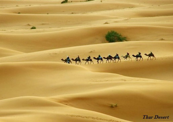
Indian Desert
The Great Indian Desert, also known as the Thar Desert, lies in the northwest of the Aravalli hills.
The Aravali Hills lie on the western and north western margins of the peninsular plateau. These are highly eroded hills and are found as broken hills between Gujarat and Delhi.
Coastal Plains
The Indian coastal plains are divided as the western coastal plains and the eastern coastal plains.
The western coastal plains are an example of submerged coastal plain.
The western coast may be divided into the following divisions − the Kachchh and Kathiawar coast in Gujarat; Konkan coast in Maharashtra; Goan coast in Karnataka, and the Malabar coast in Kerala respectively.
The Malabar Coast has certain distinctive features such as Kayals (backwaters), which are used for fishing, inland navigation, and these backwaters hold a special attraction for the tourists.
In comparison to the western coastal plains, the eastern coastal plain is broader and is an example of an Emergent coast.
The Eastern Coast is named as the Northern Circar (in the north part i.e. part of West Bengal, Odisha, etc.) and the southern part is known as the Coromandel Coast (part of Southern Andhra Pradesh and Tamil Nadu). The eastern coastal plain is known as the Northern Circars in the region between Krishna and Mahanadi rivers (West Bengal, Odisha, etc.) and as the Coromandel Coast in southern part between Krishna and Kaveri rivers (Andhra Pradesh and Tamil Nadu).
Islands
There are two major island groups in India, i.e., one in the Bay of Bengal (Andaman and Nicobar) and the other in the Arabian Sea (Lakshadweep).
The Bay of Bengal island group consists of about 572 islands/islets.
The two principal groups of islets include the Ritchies archipelago and the Labyrinth Islands.
However, the entire group of islands is divided into two broad categories − the Andaman in the north and the Nicobar in the south and they are separated by Ten Degree Channel.
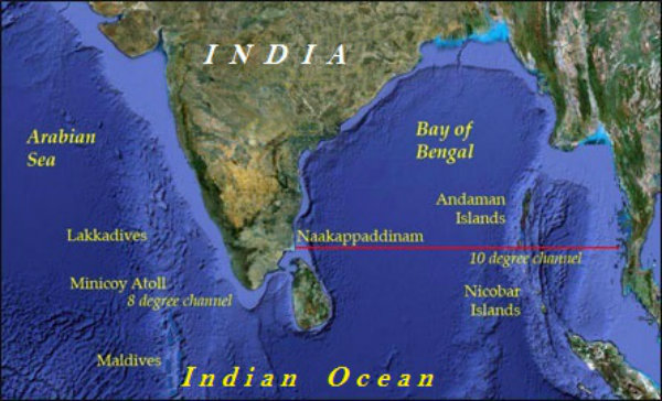
Situated in the Nicobar Islands, Barren Island is the only active volcano in India.
Located on the North Andaman, Saddle peak (738 m) is the highest peak of the region.
Lakshadweep and Minicoy are the islands of the Arabian Sea.
The entire island group of Lakshadweep is built of coral deposits.
There are approximately 36 islands, among which, 11 are inhabited.
The entire group of islands is broadly divided by the Eleventh-degree channel. The Amini Island lies to the north and the Cannanore Island lies to the south of the channel.
