- Geography India - Introduction
- Geography India - Physical Aspect
- Geography India - Drainage System
- Geography India - Climate
- Geography India - Natural Vegetation
- Geography India - National Forest
- Geography India - Wildlife
- Geography India - Soil
- Geography India - Land Resources
- Geography India - Agriculture
- Geography India - Mineral Resources
- Geography India - Energy Resources
- Geography India - Industry
- Geography India - Transport
- Geography India - Communication
- Geography India - Foreign Trade
- Geography India - The People
- Geography India - Settlement
- Geography India - Migration
- Regional Development
- Geography India - Disasters
- Geography of the World
- Geography World - Introduction
- Evolution of the Earth
- Geography World - Climate
- Geography World - Transport
- Geography World - Communications
- Geography World - Population
- Human Settlement
- Human Development
- International Trade
- Geography Useful Resources
- Geography - Online Quiz
- Geography - Online Test
- Geography - Quick Guide
- Geography - Useful Resources
- Geography - Discussion
Geography India - Communications
Radio
Radio broadcasting was started in India in 1923 by the Radio Club of Bombay.
Government took control over radio broadcasting in 1930 and established the Indian Broadcasting System.
All India Radio was constituted in 1936 and it came to be known as Akashwani from 1957.
Over a period of time, All India Radio started broadcasting a variety of programs related to information, education, and entertainment.
Among all programs, news bulletins were also broadcasted at specific occasions like the session of parliament and state legislatures.
Television
Television first went on air in 1959.
Television broadcasting has emerged as an effective audio-visual medium for disseminating information as well as educating masses.
By 1972, many Television broadcasting centers became operational throughout the country.
In 1976, TV was separated from All India Radio (AIR) and got a separate identity as Doordarshan (DD).
Indian Satellites
With the advent of satellites, the Indian Communication System has revolutionized the mode of communication.
After INSAT-IA (National Television-DD1) became operational, Common National Programs (CNP) were started for the entire network. Services were also extended to the backward and rural areas of the country.
On the basis of configuration and purposes, satellite system in India can be grouped as −
Indian National Satellite System (INSAT) and
Indian Remote Sensing satellite system (IRS).
The INSAT, which was established in 1983, is a multipurpose satellite system specialized for telecommunication, meteorological observation, and for many other data and programs.
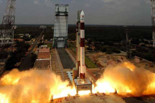
The IRS satellite system became operational only after the launch of IRS-IA in March 1988 from Vaikanour, Russia.
However, India has also developed its own Launch Vehicle PSLV (Polar Satellite Launch Vehicle).
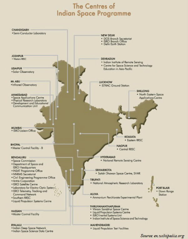
The National Remote Sensing Centre (NRSC) at Hyderabad is responsible for acquisition, processing, supply of aerial and satellite remote sensing data and continuously exploring the practical uses of remote sensing technology.
