- Satellite Communication - Home
- Introduction
- Orbital Mechanics
- Kepler’s Laws
- Earth Orbit Satellites
- Look Angles & Orbital Perturbations
- Launching
- Subsystems
- AOC Subsystem
- TTCM Subsystem
- Power & Antenna Subsystems
- Transponders
- Earth Segment Subsystems
- Examples of Earth Stations
- Link Budget
- Multiple Access Techniques
- Satellite Services
- Global Positioning System
Global Positioning System
Global Positioning System (GPS) is a navigation system based on satellite. It has created the revolution in navigation and position location. It is mainly used in positioning, navigation, monitoring and surveying applications.
The major advantages of satellite navigation are real time positioning and timing synchronization. Thats why satellite navigation systems have become an integral part in most of the applications, where mobility is the key parameter.
A complete operational GPS space segment contains twenty-four satellites in MEO. These satellites are made into six groups so that each group contains four satellites. The group of four satellites is called as one constellation. Any two adjacent constellations are separated by 60 degrees in longitude.
The orbital period of each satellite is approximately equal to twelve hours. Hence, all satellites revolve around the earth two times on every day. At any time, the GPS receivers will get the signals from at least four satellites.
GPS Codes and Services
Each GPS satellite transmits two signals, L1 and L2 are of different frequencies. Trilateration is a simple method for finding the position (Latitude, Longitude, Elevation) of GPS receiver. By using this method, the position of an unknown point can be measured from three known points
GPS Codes
Following are the two types of GPS codes.
- Coarse Acquisition code or C/A code
- Precise code or P code
The signal, L1 is modulated with 1.023 Mbps pseudo random bit sequence. This code is called as Coarse Acquisition code or C/A code and it is used by the public.
The signal, L2 is modulated with 10.23 Mbps pseudo random bit sequence. This code is called as Precise code or P code and it is used in military positioning systems. Generally, this P code is transmitted in an encrypted format and it is called as Y code
The P code gives better measurement accuracy when compared to C/A code, since the bit rate of P code is greater than the bit rate of C/A code.
GPS Services
Following are the two types of services provided by GPS.
- Precise Positioning Service (PPS)
- Standard Positioning Service (SPS)
PPS receivers keep tracking of both C/A code and P code on two signals, L1 and L2. The Y code is decrypted at the receiver in order to obtain P code.
SPS receivers keep tracking of only C/A code on signal, L1.
GPS Receiver
There exists only one-way transmission from satellite to users in GPS system. Hence, the individual user does not need the transmitter, but only a GPS receiver. It is mainly used to find the accurate location of an object. It performs this task by using the signals received from satellites.
The block diagram of GPS receiver is shown in below figure.
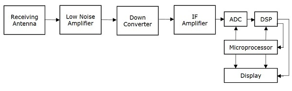
The function of each block present in GPS receiver is mentioned below.
Receiving Antenna receives the satellite signals. It is mainly, a circularly polarized antenna.
Low Noise Amplifier (LNA) amplifies the weak received signal
Down converter converts the frequency of received signal to an Intermediate Frequency (IF) signal.
IF Amplifier amplifies the Intermediate Frequency (IF) signal.
ADC performs the conversion of analog signal, which is obtained from IF amplifier to digital. Assume, the sampling & quantization blocks are also present in ADC (Analog to Digital Converter).
DSP (Digital Signal Processor) generates the C/A code.
Microprocessor performs the calculation of position and provides the timing signals in order to control the operation of other digital blocks. It sends the useful information to Display unit in order to display it on the screen.
