- Rohtasgarh Fort, Rohtas
- Rohtasgarh Fort - Home
- Rohtasgarh Fort - Overview
- Rohtasgarh Fort - History
- Rohtasgarh Fort - Architecture
- How to Reach Rohtasgarh Fort?
- Rohtasgarh Fort - Nearby Places
- Rohtasgarh Fort Useful Resources
- Rohtasgarh Fort - Quick Guide
- Rohtasgarh Fort - Useful Resources
- Rohtasgarh Fort - Discussion
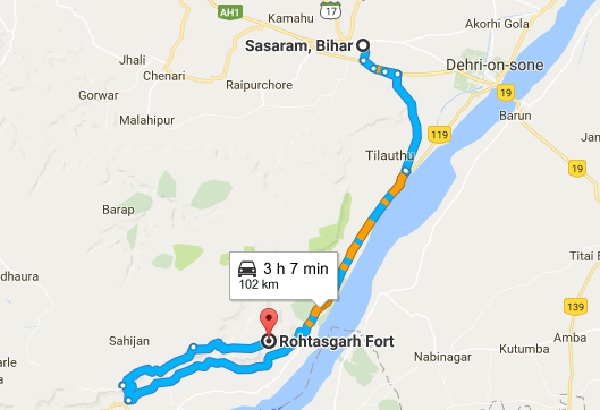
How to Reach Rohtasgarh Fort?
Rohtasgarh Fort is 102km away from Sasaram which is well-connected to various cities through road and rail transport. There is no airport in Sasaram but Gaya is the nearby airport from where tourists can catch a bus or train or hire a taxi to Sasaram.
The distance of Sasaram from the nearby cities are as follows −
Sasaram to Patna
- By rail – 195km
- By road – 158km
Sasaram to Gaya
- By rail – 103km
- By road – 144km
Sasaram to Mughalsarai
- By rail – 100km
- By road – 102km
Sasaram to Varanasi
- By rail – 117km
- By road – 136km
Sasaram to Howrah
- By rail – 561km
- By road – 548km
Sasaram to Allahabad
- By rail – 253km
- By road – 238km
By Air
Sasaram does not have airport but Gaya airport is nearby which is around 144km away. Gaya airport is an international airport from where domestic as well as international flights can be caught. From Gaya, tourists can catch bus, or train or hire a taxi to reach Sasaram.
By Train
Sasaram is well-connected to many cities by train. No Rajdhani and Shatabdi have stoppage here but Garib Rath, superfast and fast trains have stoppage here. Besides these, many passenger trains also pass through the town.
By Road
Sasaram is well-connected by road to many cities. Grand Trunk road was constructed during the reign of Sher Shah Suri and later many road networks connected the town to various cities. National Highway 30 connects Sasaram to Patna whereas National Highway 2 connects it to Kolkata and Delhi. State Highway 2 connects Sasaram to Arrah. BSRTC operates buses to many places. Besides this, private bus operators also operate buses from Sasaram.
Local Transport
The best way to get around Sasaram are auto rickshaws. Tourists can either reserve an auto or go on shared basis. Besides autos, hand-pulled rickshaws and tongas are also a good mode of transport.