- Ancient Indian History - Home
- Study of Indian History
- Writing of Ancient Indian History
- Imperialist Historiography
- Historiography Nationalist Approach
- Marxist School of History
- Sources of Ancient Indian History
- Archaeological Sources
- Geographical Background
- Geography in Ancient Literature
- Stone Age Cultures
- Mesolithic Culture
- The Neolithic Age
- Chalcolithic Period of India
- Chalcolithic Culture In India
- Harappan Civilization
- Harappan Town Planning
- Harappan Crafts & Industries
- Harappan Culture
- Harappan Religion
- Harappan Chronology
- Vedic Civilization
- Vedic Society
- Vedic Politics
- Vedic Religion & Philosophy
- The Aryan Invasion
- Later Vedic Age
- Social System after Vedic Age
- Achievements of Indian Philosophy
- Evolution of Jainism
- Evolution of Buddhism
- Alexander’s Campaign in India
- Maurya Dynasty
- Kalinga War & its Impact
- Society & Economy during Mauryas
- Mauryan Governance
- Early History of South India
- Age of Smaller Dynasties
- Literature of Satavahana Period
- Society of Satavahana Period
- Economy of Satavahana Period
- Technology of Satavahana Period
- Chola Dynasty
- Pandya Dynasty
- Chera Dynasty
- Period of Foreign Invaders
- Gupta Period
- Decline of Guptas
- Governance of Gupta Period
- Literature of Gupta Period
- Economy in Gupta Period
- Science & Tech of Gupta Period
- India after the Gupta Period
- Period of Harsha
- South India during the Harsha Period
- Kadamba Dynasty
- History of Kamarupa
- India after Harsha
- Gurjara Pratiharas
- Palas of Bengal
- Rashtrakutas of Deccan
- Literature after the Harsha Period
- Society after the Harsha Period
- Economy after the Harsha Period
- Religion after the Harsha Period
- References & Disclaimer
- Ancient Indian History - Online Quiz
- Ancient Indian History - Online Test
- Ancient Indian History - Quick Guide
- Ancient Indian History - Resources
- Ancient Indian History - Discussion
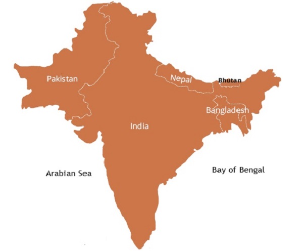
Geographical Background of Indian History
Indian subcontinent comprises six countries (as shown in the image given below) namely −
Afghanistan,
Pakistan,
Nepal,
India,
Bhutan, and
Bangladesh.
The whole subcontinent was known as Bharatavarsha or Hindustan in ancient time.
The word Hindustan is derived from the name of the river Sindhu, pronounced by the westerners as Hindu or Indu. The name India is thus derived.
The name India is called as Bharata in the Indian Constitution.
Geographical Division
The geographical boundaries of Bharatavarsha are demarcated by −
The Himalayas in the north;
The Pamir plateau and Sulaiman Kirthar ranges in the western and north-western side;
The Bay of Bengal in the east and Arabian Sea in the west; and
The Indian Ocean in the south.
The physiography of the subcontinent can be studied under the three following parts −
The Himalayas,
The Indo-Gangetic-Brahmaputra plain, and
The Deccan plateau.
The Himalayas
The Himalaya is about 2,400 Km long (from east to west) and about 250 to 320 km wide (north to south).
The Himalaya touches Afghanistan in the west to Myanmar in the east.
There are about 114 peaks (of Himalayan Mountain Range), which are more than 20,000 feet high.
Some of the highest peaks (of the Himalaya) are −
Gauri Shankar or Mount Everest (it is the highest mountain peak in the world),
Kanchanjanga,
Dhaulagiri,
Nanga Parvat, and
Nanda Devi.
The Himalayas form a barrier against the foreign invasions from the north.
The Khyber and Bolan passes were well known since the ancient time. Khyber Pass was popular as the gateway to India.
The Indo-Gangetic-Brahmaputra Plain
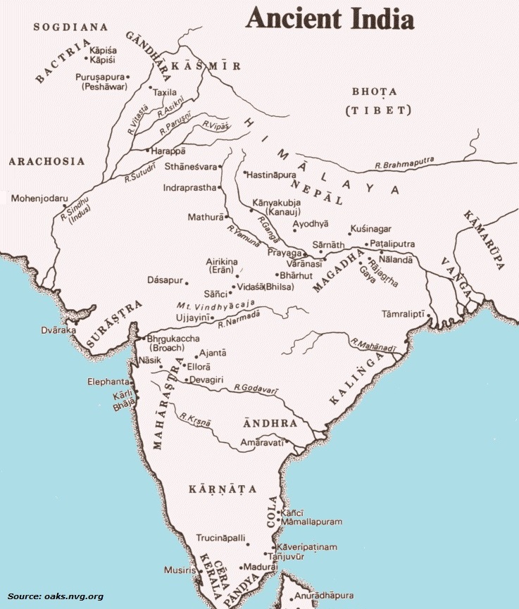
The great plain lies to the south of the Himalayas. It covers more than 255 million hectares fertile plain area.
The great plain is formed by the rivers originating from Himalaya.
The Indus, the Ganga, and the Brahmaputra are the three major river systems.
The ancient River Saraswati and its tributaries used to flow through the northern plain area. The stream of Saraswati had flown through the states of Haryana, Punjab, and Rajasthan.
The Indus River has five tributaries (flowing from east to west), namely −
The Sutlej (Satudri),
The Beas (Vipasa),
The Ravi (Parushni),
The Chenab (Asikni), and
The Jhelum (Vitesta).
The river Sutlej was (once) a tributary of the lost river Saraswati, but changed its course.
The Brahmaputra originating from the eastern part of the Lake Manasarovar in the Kailasa Range (of Himalaya) flows eastward through the plateau of Tibet. Before entering India, its name is Tsangpo.
The Brahmaputra enters in India and from here, it is called as the Brahmaputra. It passes through Assam and Bengal and joins the eastern most mouth of the Ganga i.e., Padma.
Originating from the Gangotri glacier, the River Ganga flows through the India and Bangladesh and finally debouches into the Bay of Bengal. It is the most sacred river of India.
The Deccan Plateau
The surface of the Deccan plateau (which is located in the southern part of the subcontinent) is tilted from west to east.
On the western side, a range of high cliffs is located (in the direction of) south to north leaving a narrow strip of plain between it and the sea. It is known as the Western Ghats.
The Eastern Ghats (which is situated along the eastern coast) is divided into groups of low hills. It has several gaps through which the peninsular rivers join the Bay of Bengal.
Central Indian Plateau
The Central Indian plateau stretches from Gujarat in the west to Chhota Nagpur in the east.
Thar, the Great Indian Desert lies to the north-west of the Aravalli range.
Central Indian plateau consists of Malwa plateau, Bundelkhand, and Baghelkhand.
The Coastal Regions
The western coastal plain stretches from the Gulf of Cambay in the north to Kerala in the south.
The northern part of the western coast is called the Konkan coast. And, the southern one is called the Malabar Coast.
Some of the ideal harbors are located in the Konkan and Malabar region.
The eastern coast has a few natural harbor. The natural harbors provide an opportunity for maritime activities during the historical period, which lead to more vigorous and fruitful contacts with the south-east Asian countries.
The southern tip of the peninsula is known as Cape Comorin.
Climate
The Indian subcontinent is located largely in the tropical zone and has a fairly warm climate throughout the year.
The Indian subcontinent has three seasons namely, winter, summer, and rainy.
March to June is the hot season. The temperature goes up to 48° C or more in some regions. It follows the rainy season from July to October.
The south-west monsoon brings rain in the country.
The regions of Haryana, Rajasthan, and some parts of Sind and Gujarat receive less rainfall, but during the ancient time, it received higher rainfall and created an ideal condition for the development of the Harappan civilization.
