
Article Categories
- All Categories
-
 Data Structure
-
 Networking
-
 RDBMS
RDBMS
-
 Operating System
-
 Java
Java
-
 MS Excel
-
 iOS
iOS
-
 HTML
HTML
-
 CSS
CSS
-
 Android
-
 Python
-
 C Programming
-
 C++
C++
-
 C#
C#
-
 MongoDB
-
 MySQL
MySQL
-
 Javascript
-
 PHP
PHP
-
 Economics & Finance
Simultaneous Localization and Mapping
Introduction
Simultaneous Localization and Mapping or SLAM is a method that let us build a map and locate our vehicles on that map at the same time. SLAM algorithms are used for unknown environment mapping and simultaneous localization.
How is SLAM useful?
Engineers can use SLAM for avoiding obstacles and also use them for path planning.
SLAM software allows robot systems, drones, or autonomous vehicles to find paths in unknown environments and difficult terrains. This process involves a high amount of computing and processing power.
SLAM can be useful for mapping areas that are too small or dangerous for human exploration
Working of SLAM
There are two types of technology used in Simultaneous Localization and Mapping.
First (Range Measurement), the fronted end processor which contains a signal processor or sensor and heavily depends on the type of sensor and its efficiency. SLAM solutions include external devices that allow robots or other vehicles to observe the environment around them. This can be a camera, a strong sensor, or a LiDAR to measure the physical properties of the environment like location, distance, or velocity.
Second (Data extraction and post-process), is the back-end stack which does not contain any sensor but can receive the signal from the front end and do pose-graph optimization. The "back-end" solutions serve the purpose of extracting data collected by sensors or measuring instruments. This information is processed and used to identify landmarks in the surrounding environment. They may contain complex computer software with highly efficient algorithms running.
Let's have a look into a few Front-end processing components.
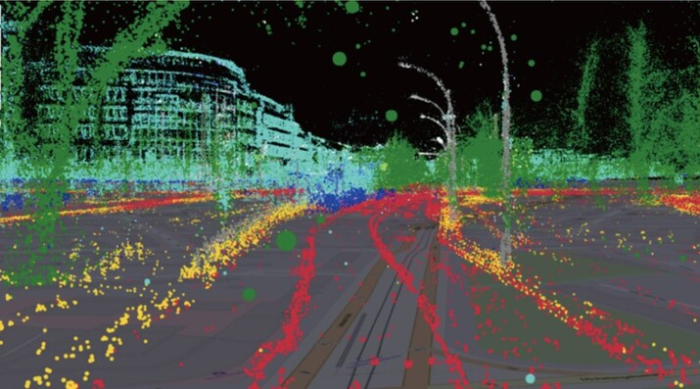
LiDAR
LiDAR stands for Light Detection and Ranging. It uses light to locate unfamiliar objects by using a light sensor. They are the most popular for Simultaneous localization. LiDAR technology uses light energy to collect data from the physical environment by using a laser beam that gets reflected from the target on hitting it and then measuring the time required for the beam to return. This process is used to generate highly accurate maps of unknown topography and 3D models of the surrounding environment.
A LiDAR requires very little energy to operate. It can gather highly accurate data of any obstacle by using a beam of laser or high energy light source which may not be visible to the human eye. 2D LIDAR SLAM is used by robots. In autonomous vehicles, we generally use 3D LiDAR SLAMS.
Although LiDAR requires a bit of processing power at the back end, its decreasing cost has popularized its use.
Visual SLAM
It uses images obtained from cameras and other image sensors. These cameras can range from simple ones to complex camera systems capable of capturing wide-angle, panorama, and fish-eye images. RGB, Night vision and stereo cameras are also very popular. Some of these camera systems are inexpensive and are also able to perceive lots of information from the environment, and detect landmarks which eventually helps in graph optimization. Depth-sensing cameras are more powerful than monocular cameras as they can sense depth and provide more accurate measurements and Inertial Measurement Units which can capture orientation and velocity.
Uses of Simultaneous Localization and Mapping
SLAM has been widely used for research and technical and theoretical applications for decades. However due to the decreasing cost of the components(LiDAR, cameras, etc.) SLAM is finding a place in common usage.
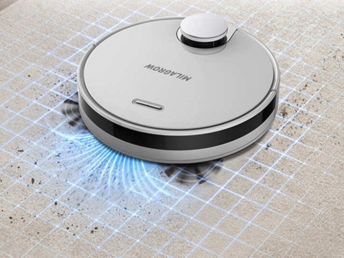
1. Floor-Cleaning Robots
We may have often come across cleaning robots in many common households. Such robots also work on the principle of Simultaneous Localization. Without SLAM a cleaning robot would just move across the floor not able to detect obstacles or remember the places which it had cleaned before. Using SLAM, a vacuum robot can localize and map the floor and will also be able to effectively avoid obstacles of any kind.
2. AR/VR Applications
SLAM-powered systems can be used by Virtual Reality systems to improve their haptics, feedback, audio quality, display, and Artificial Intelligence components.
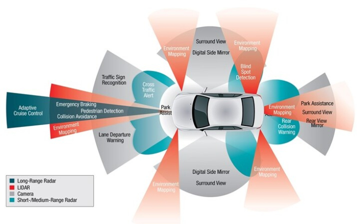
3. Self-Driving Cars
Autonomous self-driving cars heaving make use of SLAM technology for mapping the path and surrounding the vehicle. It uses several sensors like LIDAR, GPS, cameras, etc to perceive environmental parameters. Autonomous vehicles can use SLAM systems for lane detection, path propagation, identifying traffic conditions, and also read through traffic symbols and lights. Nowadays we have efficient GPS sensors which can aid SLAM systems for accurate geopositioning.
Conclusion
SLAM is an emerging technology though it used been used for over a decade for research and applications. SLAM technology has the potential to provide a realm to our intelligent systems as to how they perceive their physical environment and interact efficiently with it.

657 Views
