- DocumentDB SQL - Home
- DocumentDB SQL - Overview
- DocumentDB SQL - Select Clause
- DocumentDB SQL - From Clause
- DocumentDB SQL - Where Clause
- DocumentDB SQL - Operators
- DocumentDB - Between Keyword
- DocumentDB SQL - In Keyword
- DocumentDB SQL - Value Keyword
- DocumentDB SQL - Order By Clause
- DocumentDB SQL - Iteration
- DocumentDB SQL - Joins
- DocumentDB SQL - Aliasing
- DocumentDB SQL - Array Creation
- DocumentDB - Scalar Expressions
- DocumentDB SQL - Parameterized
- DocumentDB SQL - Built-in Function
- Linq to SQL Translation
- JavaScript Integration
- User-Defined Functions
- Composite SQL Queries
DocumentDB SQL - Spatial Function
DocumentDB also supports the Open Geospatial Consortium (OGC) built-in functions for geospatial querying. Following is a list of built-in supported spatial functions.
| S.No. | Function & Description |
|---|---|
| 1 | ST_DISTANCE (point_expr, point_expr) Returns the distance between the two GeoJSON point expressions. |
| 2 | ST_WITHIN (point_expr, polygon_expr) Returns a Boolean expression indicating whether the GeoJSON point specified in the first argument is within the GeoJSON polygon in the second argument. |
| 3 | ST_ISVALID Returns a Boolean value indicating whether the specified GeoJSON point or polygon expression is valid. |
| 4 | ST_ISVALIDDETAILED Returns a JSON value containing a Boolean value if the specified GeoJSON point or polygon expression is valid, and if invalid, additionally the reason as a string value. |
In this example, we will use the following two documents of universities which contains the location in the form of coordinates.
Following is the Case University document.
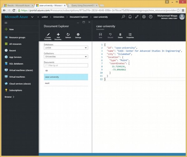
{
   "id": "case-university",
   "name": "CASE: Center For Advanced Studies In Engineering",
   "city": "Islamabad",

   "location": {
      "type": "Point",
      "coordinates": [
         33.7194136,
         -73.0964862
      ]
   }
}
Following is the Nust University document.
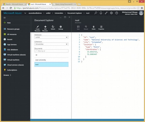
{
   "id": "nust",
   "name": "National University of Sciences and Technology",
   "city": "Islamabad",

   "location": {
      "type": "Point",
      "coordinates": [
         33.6455715,
         72.9903447
      ]
   }
}
Lets take a look at another example of ST_DISTANCE.
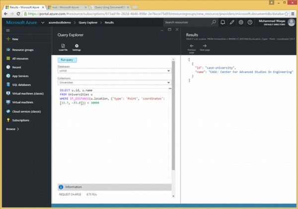
Following is the query that returns id and name of the universities documents that are within 30 km of the specified location.
SELECT u.id, u.name
FROM Universities u
WHERE ST_DISTANCE(u.location, {'type': 'Point', 'coordinates':[33.7, -73.0]}) < 30000
When the above query is executed, it produces the following output.
[
   {
      "id": "case-university",
      "name": "CASE: Center For Advanced Studies In Engineering"
   }
]
Lets take a look at another example.
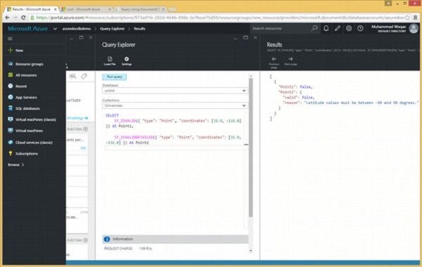
Following is the query which contains ST_ISVALID and ST_ISVALIDDETAILED.
SELECT
   ST_ISVALID({ "type": "Point", "coordinates": [32.9, -132.8] }) AS Point1,

   ST_ISVALIDDETAILED({ "type": "Point", "coordinates": [31.9, -132.8] }) AS Point2
When the above query is executed, it produces the following output.
[
   {
      "Point1": false,
      "Point2": {
         "valid": false,
         "reason": "Latitude values must be between -90 and 90 degrees."
      }
   }
]
The above output shows that ST_ISVALIDDETAILED also returns the reason why this point is invalid, but ST_ISVALID only returns the Boolean value.
